The Copernicus Sentinel-1D satellite has delivered its first stunning radar images just days after launch, showcasing remarkable clarity and detail. These images, featuring critical locations in Antarctica, South America, and Germany, signal a new era for Earth observation. According to ESA, this achievement sets a new standard for rapid data transmission from space, highlighting the satellite’s effectiveness. This milestone marks a significant step in monitoring climate change and providing valuable insights into our planet’s health.
A Swift Start: Sentinel-1D’s Quick Turnaround
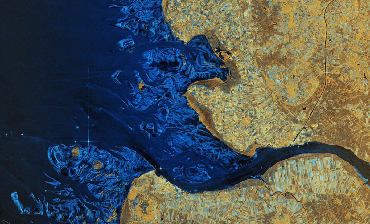
Launched on November 4, 2025, from French Guiana, the Sentinel-1D satellite was designed for fast and efficient Earth observation. Despite its recent arrival in orbit, the satellite delivered its first high-resolution images within just over two days, setting a new record for radar-based Earth observation satellites. The images were captured over significant areas such as the Antarctic Peninsula, Tierra del Fuego, and Bremen, Germany, and were processed incredibly quickly—within 50 hours of launch.
ESA highlighted this achievement as a remarkable display of teamwork and preparation. As ESA’s Sentinel-1 Mission Manager Nuno Miranda put it,
“These images have been downlinked and processed within an exceptionally short timeframe. Some of us remember that when Sentinel-1B was launched, it delivered its first radar images within two hours of activation. Sentinel-1D achieved this in an even faster time, setting what we believe is a new record for space radar.”
This rapid deployment not only showcases the satellite’s potential but also exemplifies the level of excellence achieved by the teams behind it.
Sentinel-1D’s Impressive Technology: Cutting-Edge Radar for Climate Monitoring
One of the standout features of the Sentinel-1D is its synthetic aperture radar (SAR) system, which can capture detailed images of the Earth’s surface regardless of weather conditions or time of day. This ability is especially important in monitoring polar regions, where traditional optical satellites often fail due to constant cloud cover and prolonged darkness in winter months.
The radar system on Sentinel-1D allows it to see through clouds and capture critical information about Earth’s changing landscapes, even in the most extreme conditions. Its high-resolution capabilities are pivotal in tracking glaciers, such as those in Antarctica, which are essential indicators of climate change. These detailed radar images enable scientists to monitor the rate at which glaciers are retreating and help forecast their future impact on sea levels.
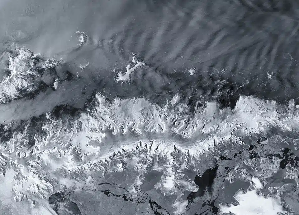 Antarctic Peninsula by Sentinel-1D. Credit: ESA
Antarctica Under the Radar: Glaciers, Ice Shelves, and Climate Change
Among the first regions imaged by Sentinel-1D was the Antarctic Peninsula, a hotspot for climate change effects. The peninsula’s glaciers, particularly those near the Thwaites Glacier, are highly vulnerable to warming temperatures. These glaciers play a critical role in the global climate system as they contribute to rising sea levels when they melt. Sentinel-1D’s images clearly highlight the contrast between the icy landmass and the surrounding ocean, providing new insights into how these glaciers are changing over time.
The images of the Antarctic Peninsula serve as a stark reminder of the fragility of these ice sheets. As ESA Director Simonetta Cheli noted,
“This is a great achievement and I am so pleased to see these results from Sentinel-1D. It really places the data we receive from our innovative missions in the spotlight – it is data that we as a society rely upon as we continue to discuss and take action on climate change.”
These images are more than just data; they are a critical tool in understanding and combating climate change.
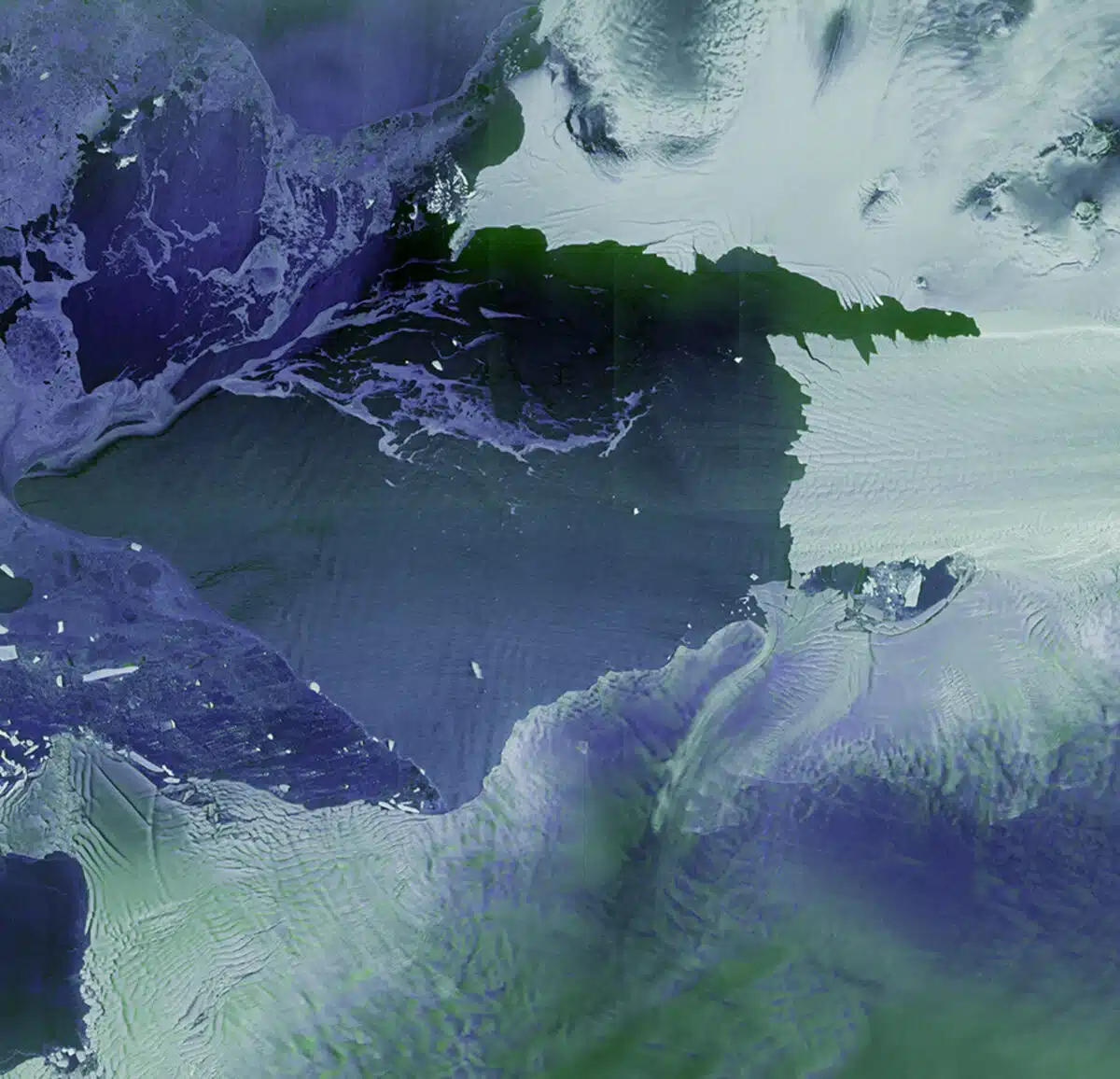 Thwaites and Pine Island glaciers by Sentinel-1D. Credit: ESA
Sentinel-1D and the Fight Against Climate Change: A Game-Changer for Global Monitoring
The first radar images from Sentinel-1D offer not only a visual record of Earth’s current state but also an essential resource for ongoing climate monitoring. These images are invaluable to scientists, policymakers, and organizations working to address climate change. The data provided by Sentinel-1D helps track environmental shifts in real time, allowing for a better understanding of the rapidly changing state of the planet.
The mission also emphasizes the importance of international collaboration. As ESA’s Sentinel-1 Project Manager Ramón Torres reflected,
“Unveiling the first images from Sentinel-1D is an incredibly emotional milestone for all of us. The sense of awe and fulfilment goes beyond the thrill of liftoff itself, because seeing those breathtaking images from the SAR instrument brings our hard work to life.”
This collaboration between space agencies and countries underscores the crucial role that satellite technology plays in tackling global environmental challenges.