Torrential rain is on the way across the country on Monday, with a rare amber weather warning coming into force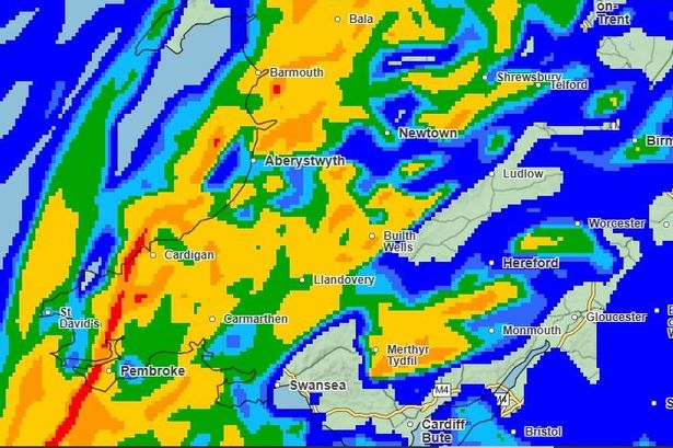 A Met Office weather map for Wales for Monday(Image: Met Office)
Wales is gearing up for a miserable Monday with hours of torrential rain and probable flooding on the way as a rare amber Met Office warning comes into force.
The forecaster cancelled a yellow warning for rain which had been in place for Saturday, November 29, but the good news didn’t last long as it then upgraded a warning for Monday, December 1, from yellow to amber, meaning “heavy rain is likely to bring some disruption and probable flooding” to parts of Wales.
The amber warning will come into force at midnight (12am) on Monday, and be in place for almost the entire day, until 11pm.
It will cover the counties of Blaenau Gwent, Bridgend, Caerphilly, Cardiff, Carmarthenshire, Merthyr Tydfil, Monmouthshire, Neath Port Talbot, Newport, Pembrokeshire, Powys, Rhondda Cynon Taf, Swansea, Torfaen, and Vale of Glamorgan.
The Met Office has said that “fast flowing or deep floodwater is possible, which could cause a danger to life.” Read the biggest stories in Wales first by signing up to our daily newsletter here.
In addition to the amber warning, there are two other warnings that affect Wales. A yellow warning for rain will be in place for the vast majority of Wales between midnight and 3am (the amber warning for south Wales will also be in place during this time).
Meanwhile, on Tuesday, another yellow warning for rain will be in place between midnight and 3am, covering north Carmarthenshire and large parts of mid and north Wales.
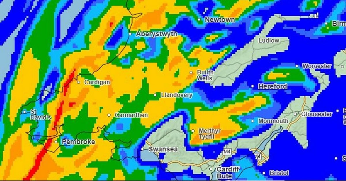
The below maps show just how bad things are likely to get and where
The first map is the Met Office forecast for 11am on Monday. Dark blue on the map means rain but less than 0.5mm per hour is expected to fall.
The lighter blue areas mean between 0.5mm and 1mm per hour, and lighter again means between 1mm and 2mm per hour.
The green areas on the map are expected to see between 2mm and 4mm of rainfall per hour, while yellow signifies areas where between 4mm and 8mm could fall.
The orange on the map signifies areas where between 8mm and 16mm of rain could fall per hour.
 (Image: Met Office)
By 12pm on Monday the outlook is just as bad, with more heavy rain spreading to the Pembrokeshire area. The whole of Wales will continue to be affected by rain at this point in the day, according to the map.
 (Image: Met Office)
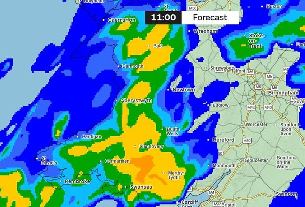
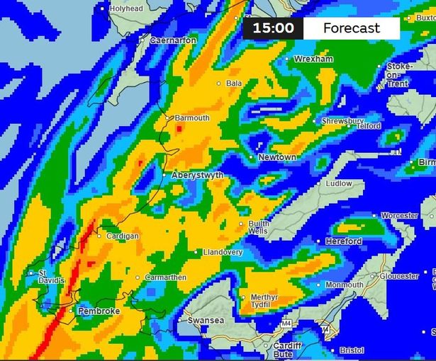
By 3pm things could get even worse, with many ‘yellow’ patches dotted around the country, including in north Wales and in the south-east and south-west of the country.
There are even a few ‘red’ dots on the map, including in the Cardigan and St David’s areas of Pembrokeshire, indicating a potential rainfall of up to 32mm per hour.
 (Image: Met Office)
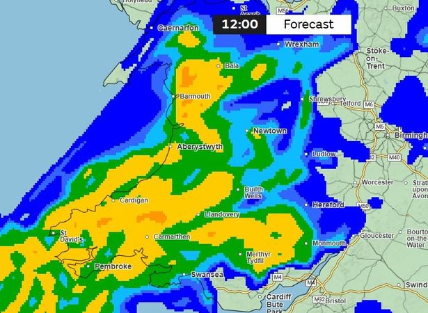
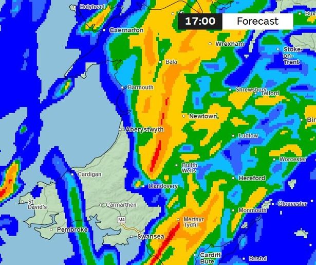
At 5pm there might be some respite for some in parts of south-west Wales, but elsewhere heavy rain will continue to batter areas from Merthyr Tydfil in the south to Aberystwyth in mid Wales, with Bala and Wrexham also expected to get a battering.
 (Image: Met Office)
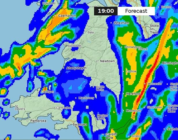
By 7pm things will have eased off somewhat, but we’re still looking at pretty persistent rainfall in the middle of the country, from north Carmarthenshire up to Ceredigion, across to Powys and south to Cardiff.
 (Image: Met Office)
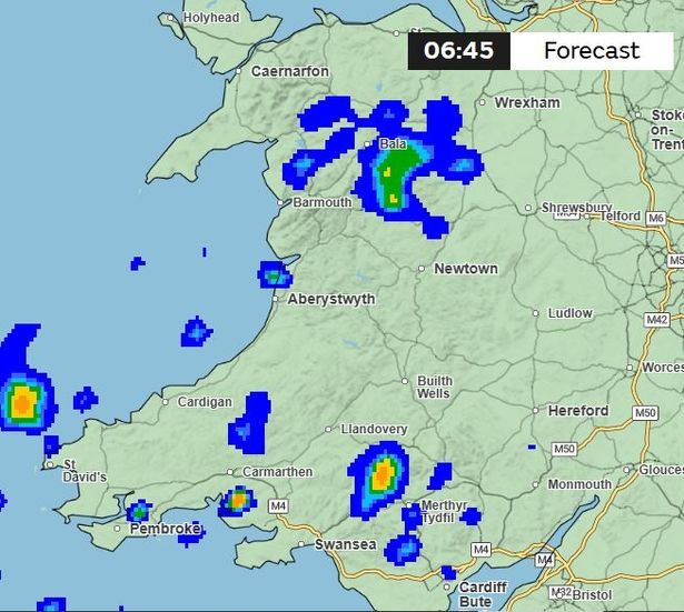
Finally, some respite. The below map shows the current forecast for 6.45am on Tuesday. While there will still be patches of rain, the heavy and persistent rainfall is expected to have subsided by then.
 (Image: Met Office)
A spokesperson for the Met Office said: “An area of heavy rain is expected to move over south Wales between late Sunday and late Monday.
“Whilst rainfall amounts will vary, some heavy and persistent rainfall is likely to fall, especially over high ground, for example Bannau Brycheiniog. Rain should clear to the east Monday night.
“Keep yourself and others safe; prepare to avoid travelling by road during potentially dangerous road conditions. If you must travel, ensure you watch for possible danger and drive cautiously.”
As of Sunday morning, Natural Resources Wales has already issued two flood alerts, a number which is expected to increase as we head into Monday.
The two already in place affect the Lower Towy area (rivers in the lower Towy catchment downstream of Llandeilo excluding Llandeilo), and rivers in south Pembrokeshire.
Get daily breaking news updates on your phone by joining our WhatsApp community here. We occasionally treat members to special offers, promotions and ads from us and our partners. See our Privacy Notice.