A powerful bomb cyclone explodes over the Great Lakes Sunday night, crashing the central pressure to near 975 mbar while fueling Winter Storm Ezra with blizzard conditions and widespread travel disruptions. Behind the storm, the Polar Vortex unleashes another frigid cold Arctic blast across Canada and the United States, plunging temperatures 30–40°F in hours and pushing cold air deep into the Southeast by Monday, reaching Florida on Tuesday.
Another frigid cold air mass is forecast to arrive in the New Year, with another Arctic blast spreading from Canada into the Great Lakes, Northeast U.S., and the East Coast, persisting into the first days of January 2026.
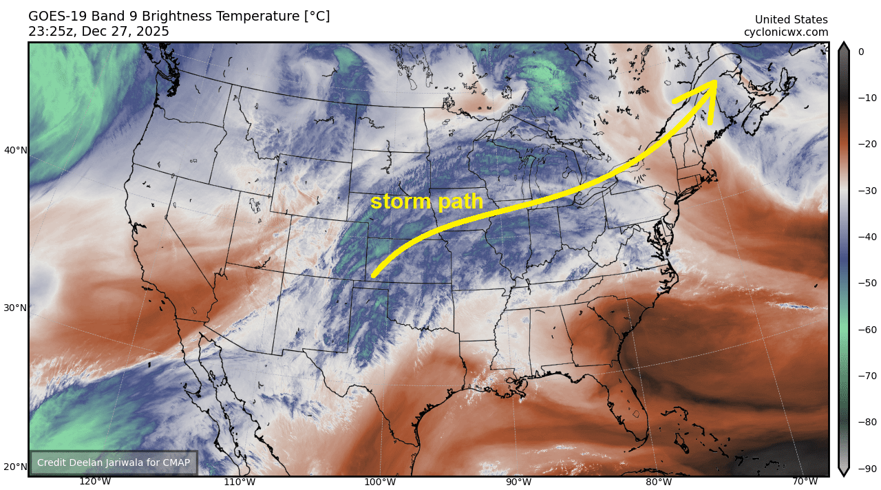
Attached below is the water vapour satellite image of the developing high-impact Winter Storm that is coming up on Sunday night. An intensifying surface cyclone over the Great Plains is pulling the warm, moist air mass from the Gulf into the eastern United States, while Arctic air is gradually spreading southward from Canada.
The yellow arrow indicates the storm’s track, curving from the southern Plains across the Midwest to the Great Lakes on Sunday, then emerging across Ontario towards Atlantic Canada through Monday.
Storm Ezra will produce widespread snow, severe winds, blizzard, and travel disruption along and north of its track, with high temperatures falling behind the Arctic front.
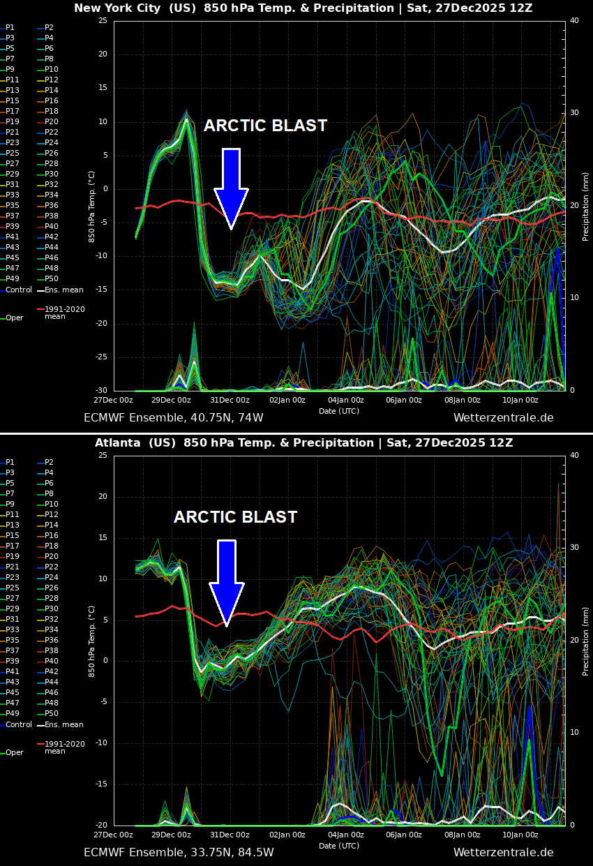
We usually use the ensemble forecast to represent the intensity of the Arctic cold pool. The following charts for New York and Atlanta reveal a textbook Arctic air mass, with plunging temperatures into a deep freeze as unseasonable cold follows in the wake of the Winter Storm Ezra.
A sharp temperature decline hints that the Arctic front will rapidly move across the eastern two-thirds of the United States, followed by a sharp temperature change and a hard freeze behind it.
Over the next 10 to 14 days, the weather dynamics over North America will remain elevated, with strong temperature contrasts across Canada and the U.S. Multiple cold outbreaks will follow, including more winter storms.
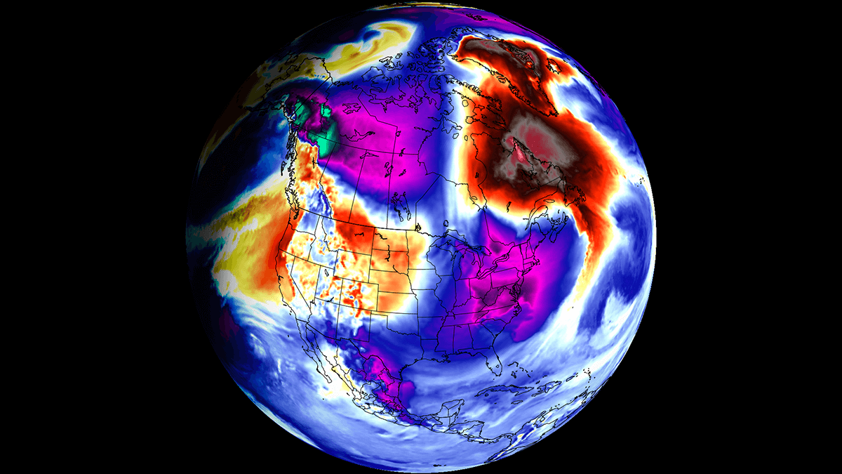
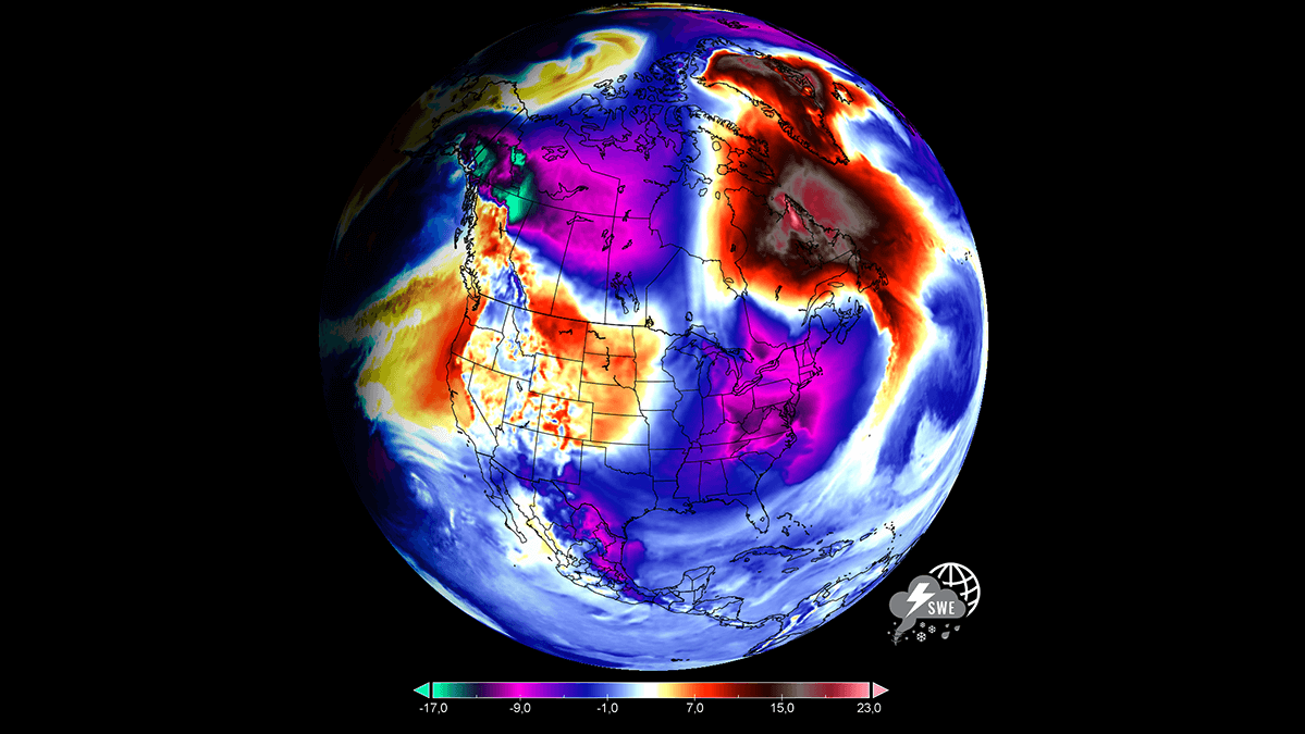
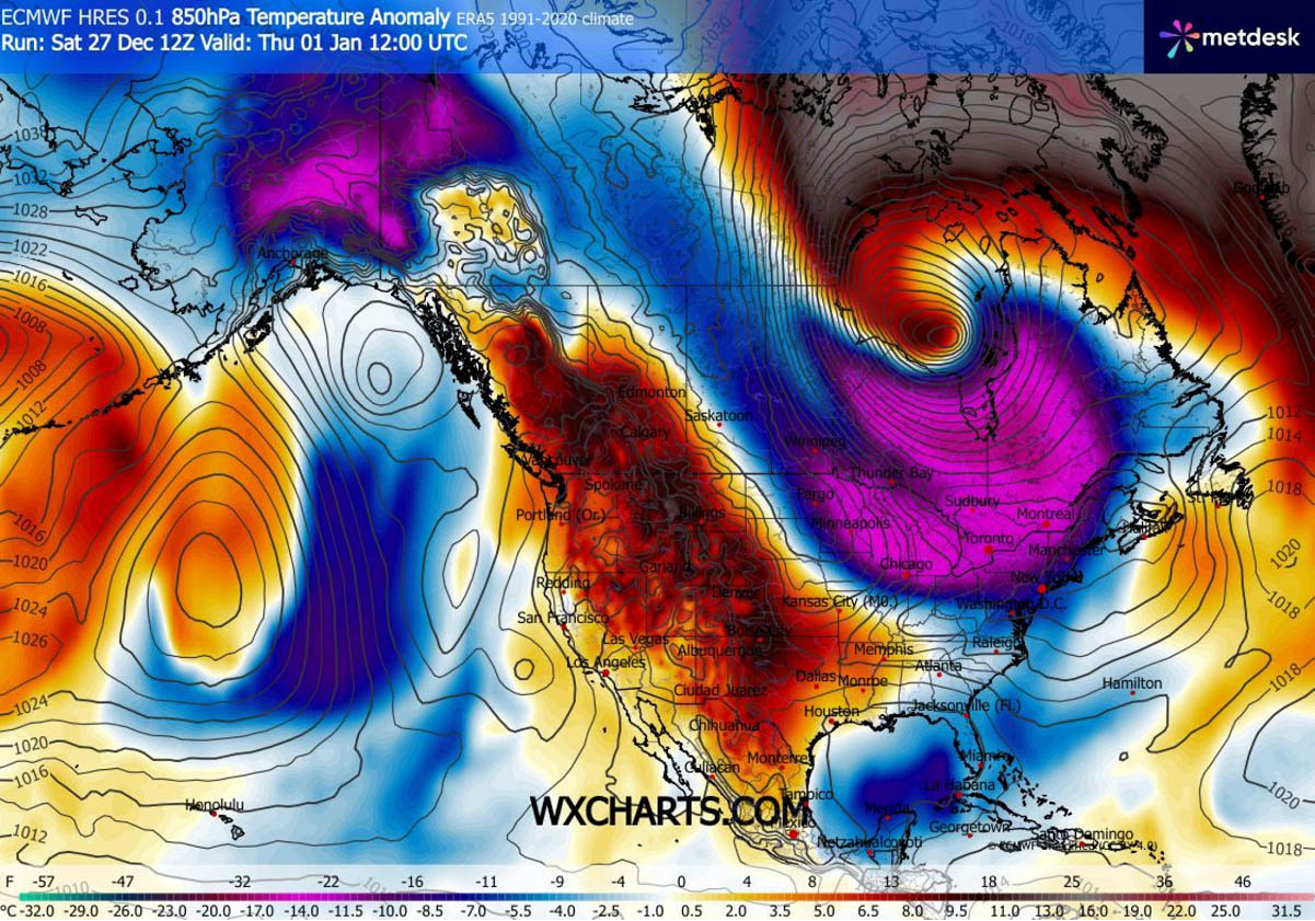
The video animation below takes us through early January across the continent, revealing extreme temperature anomalies flipping from strong warmth to extreme cold, associated with the Polar Vortex lobe sending cold waves southward.
Following the unusually early Polar Vortex split this month, the Polar Vortex is now regaining strength. But its southern lobe again slammed into North America, allowing more Arctic cold-air outbreaks to push far south from Canada into the United States as we head into January.
First, let’s examine what this feature is and why it is essential to understand its mechanism. Then, we will go through the weather picture for the final outlook and walk you through the details below.
What is the Polar Vortex?
The Earth’s atmosphere has six layers. Most of the dynamics for our daily weather occur in the lowest two layers, known as the troposphere and the stratosphere.
The troposphere is the layer closest to the Earth’s surface. It is about 12 km deep and extends from the ground up high into the sky. Depending on where you live, its depth varies from around 8 km to almost 20 km. The troposphere is deepest over the equatorial region and becomes much thinner over the North and South poles.
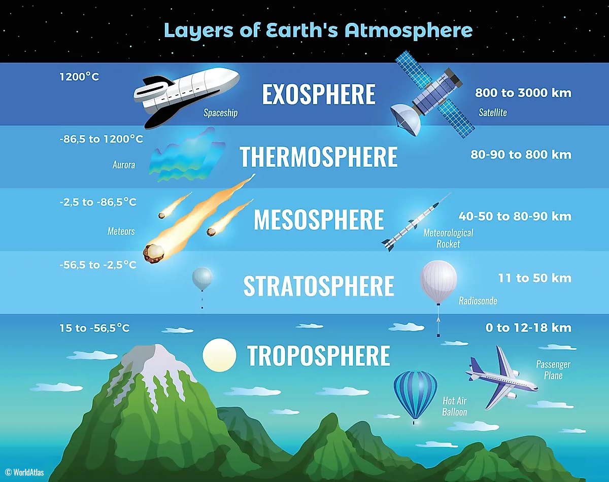
Above this layer is a much deeper one known as the Stratosphere, an 11-50 km thick layer of arid air. Another essential feature in the stratosphere, which makes our weather even more variable, often triggers significant, large-scale, long-lasting winter weather events.
This is the Polar Vortex—an enormous, tri-dimensional ring of powerful winds moving through the sky above us. The Polar Vortex is spinning around the North Pole, grazing through the air at about 20-50 km above the Earth’s surface with violent wind speeds.
How and when does the Polar Vortex form?
Due to the Earth’s inclination, the polar regions receive much less energy from the Sun during the fall months. This makes the cooling over the northern areas more robust. As a result, polar nights can last several consecutive months, followed by days without sunlight.
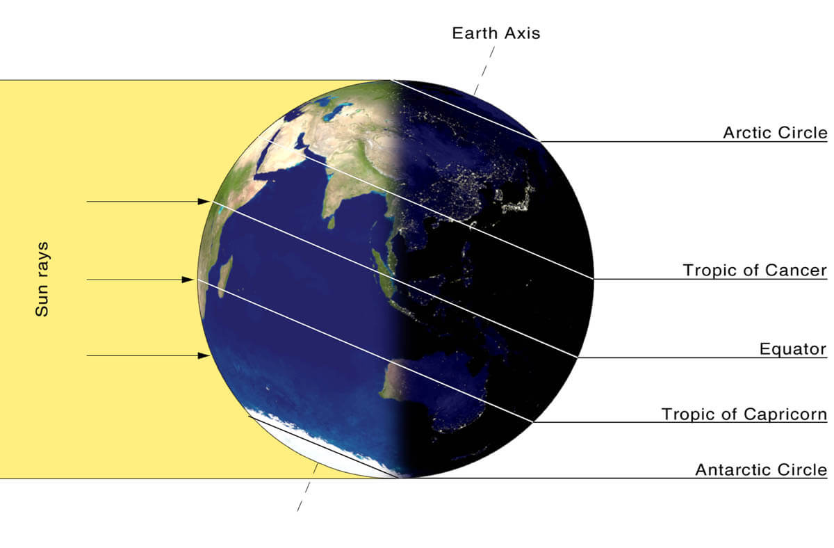
While temperatures in the polar regions are dropping into a deep freeze, the atmospheric layers farther to the south are still relatively warm because they receive more of the Sun’s energy at the same time. Therefore, the south’s equatorial layers remain much warmer than the areas farther north, leading to a high-temperature contrast.
Cooling the polar regions also lowers the ambient surface pressure, and a similar weather process occurs in the stratosphere. The temperature difference between the North Pole and the equatorial areas increases across both layers.
This creates a large, low-pressure cyclonic circulation across the polar stratosphere, where it takes its famous name—the Polar Vortex.
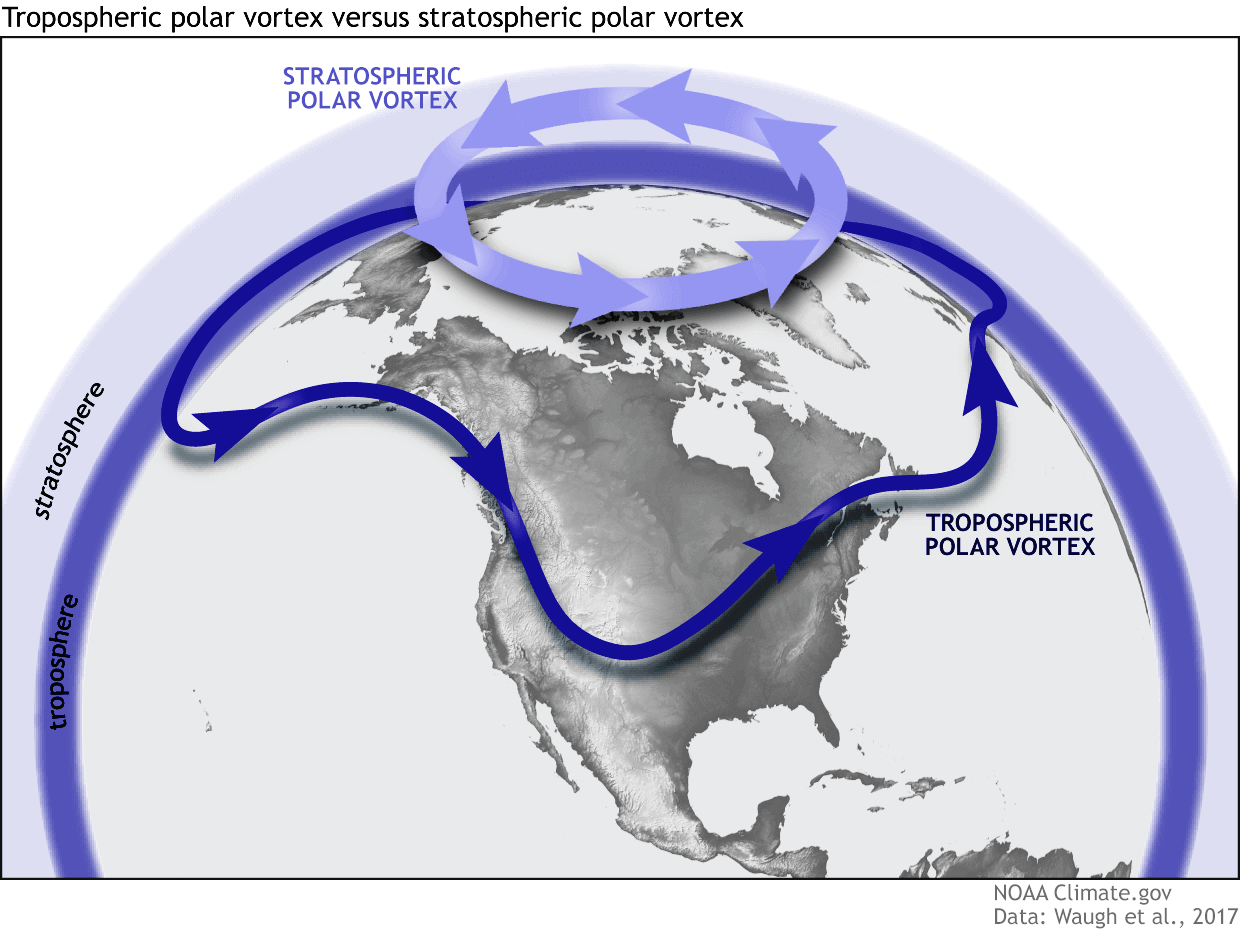
As shown in the image above, we monitor two atmospheric layers during wintertime: the troposphere and the stratosphere. The first is the lowest layer, and the second is at a higher altitude. The Polar Vortex rises through both layers, but with different strengths, shapes, and impacts.
For this reason, we separate the entire Polar Vortex into an upper (stratospheric) and a lower (tropospheric) part. When the Polar Vortex is strong, it traps colder air in the polar regions, preventing its escape and creating milder conditions for most of the United States, Europe, and other mid-latitudes.
But when the Polar Vortex gets disrupted or even entirely collapses, it can’t fully contain the cold air, which can now easily escape from the polar regions into the United States or other mid-latitude regions. Below is an example of how a disrupted Polar Vortex brings cold polar air into the United States and Europe.
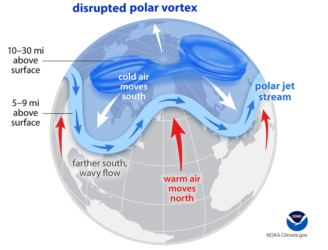
We have experienced this in Asia, Canada, the U.S., and sometimes Europe in recent years. The vortex aloft has been significantly disrupted, and when its lobe shifts on the other side of the northern hemisphere, the extreme cold grips the North American continent.
The disruption of the Polar Vortex and its split at the start of the meteorological Winter season of 2025/26 were the primary triggers of the frigid cold outbreaks in Siberia, Alaska, and Yukon, with temperatures reaching nearly -75 °F (-60 °C) this month.
Bomb Cyclone takes place on Sunday, develops A Winter Storm Ezra over the Great Lakes
The current weather pattern across Canada and the U.S. reveals an intense blocking high with a ridge that dominates western North America. At the same time, downstream, a deep trough digs sharply into the Eastern U.S. This trough is compact, deep, and intense, perfectly vertically stacked, which means that it will support a rapid surface cyclogenesis.
This is a textbook large-scale pattern that will result in a high-impactful Winter Storm Ezra.
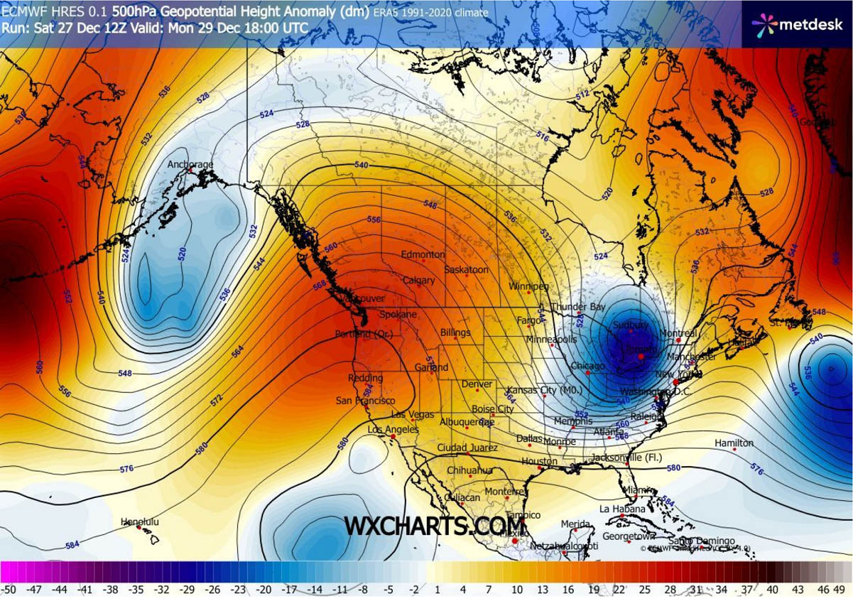
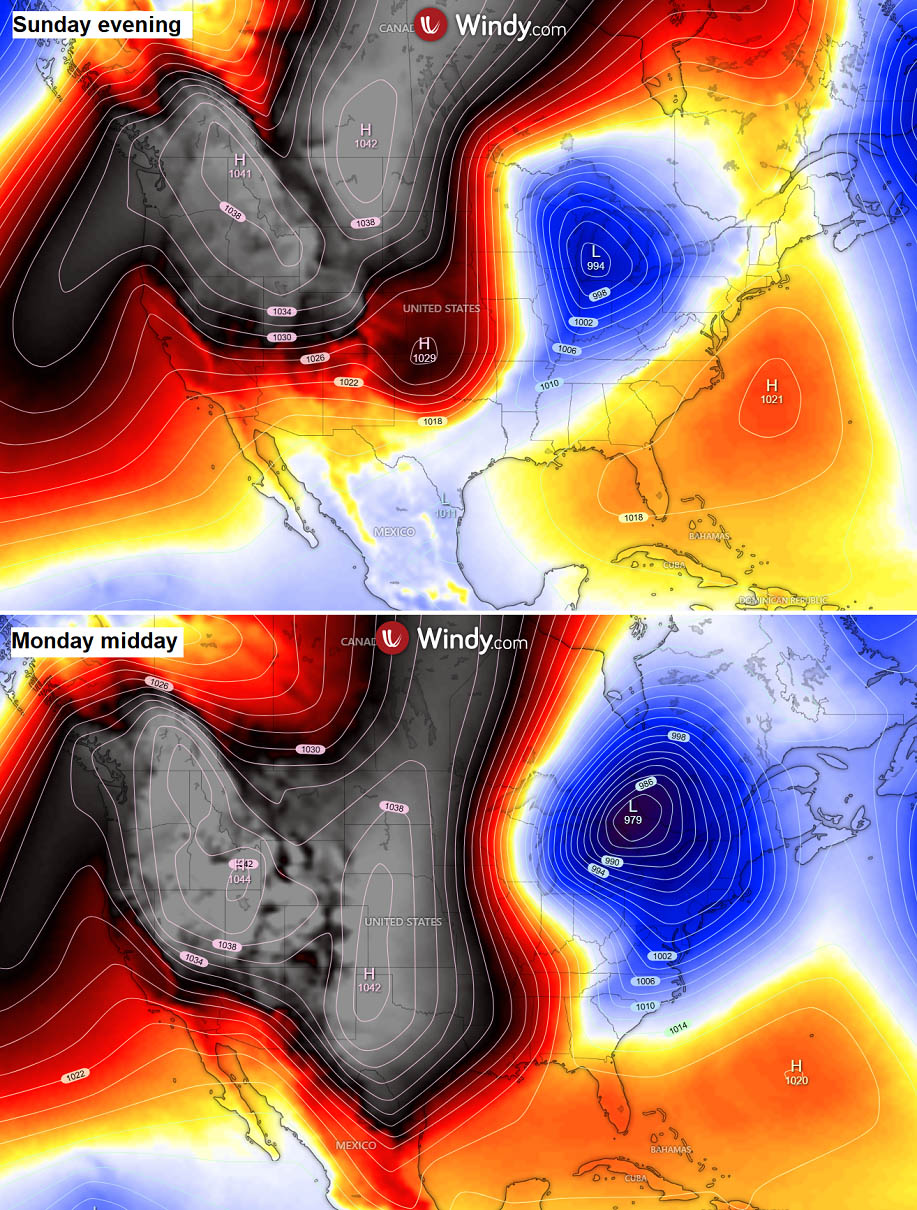
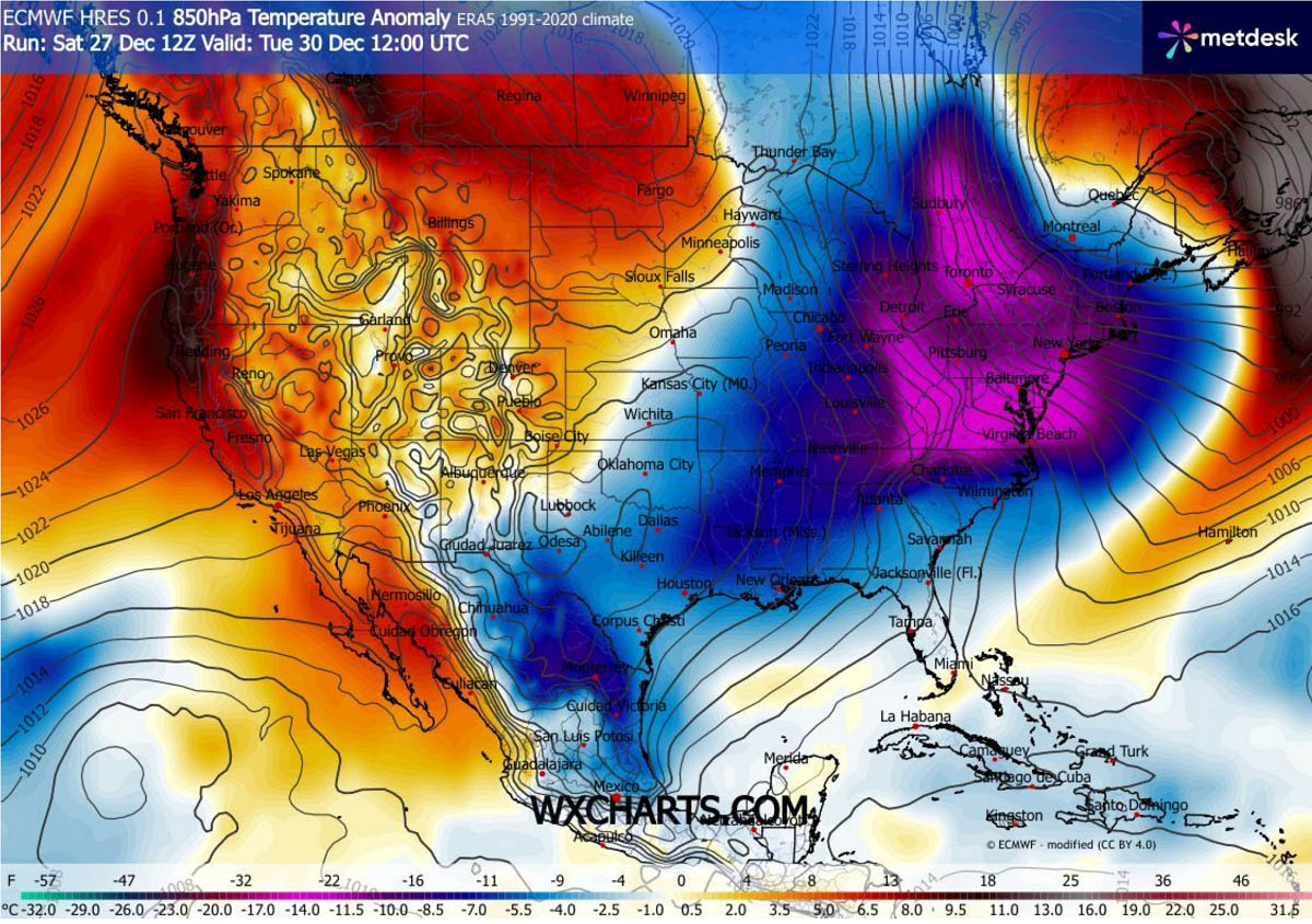
On the surface pressure chart, we can see a deepening surface low (~994 mbar) over the Midwest and Great Lakes on Sunday evening. While to the west, a broad, strong continental high-pressure system (above 1040 mbar) dominates the western U.S. and Canada. This will reinforce the Arctic cold push in the system’s wake on Monday.
By Monday midday, the bomb cyclone rapidly intensifies and shifts east, dropping to around 979 mbar over the Northeast U.S. and eastern Canada, with a powerful Winter Storm fully developed. The isobars (lines that connect points of equal pressure) are very close together, indicating a strong pressure gradient and very strong to severe winds that support blizzard conditions.
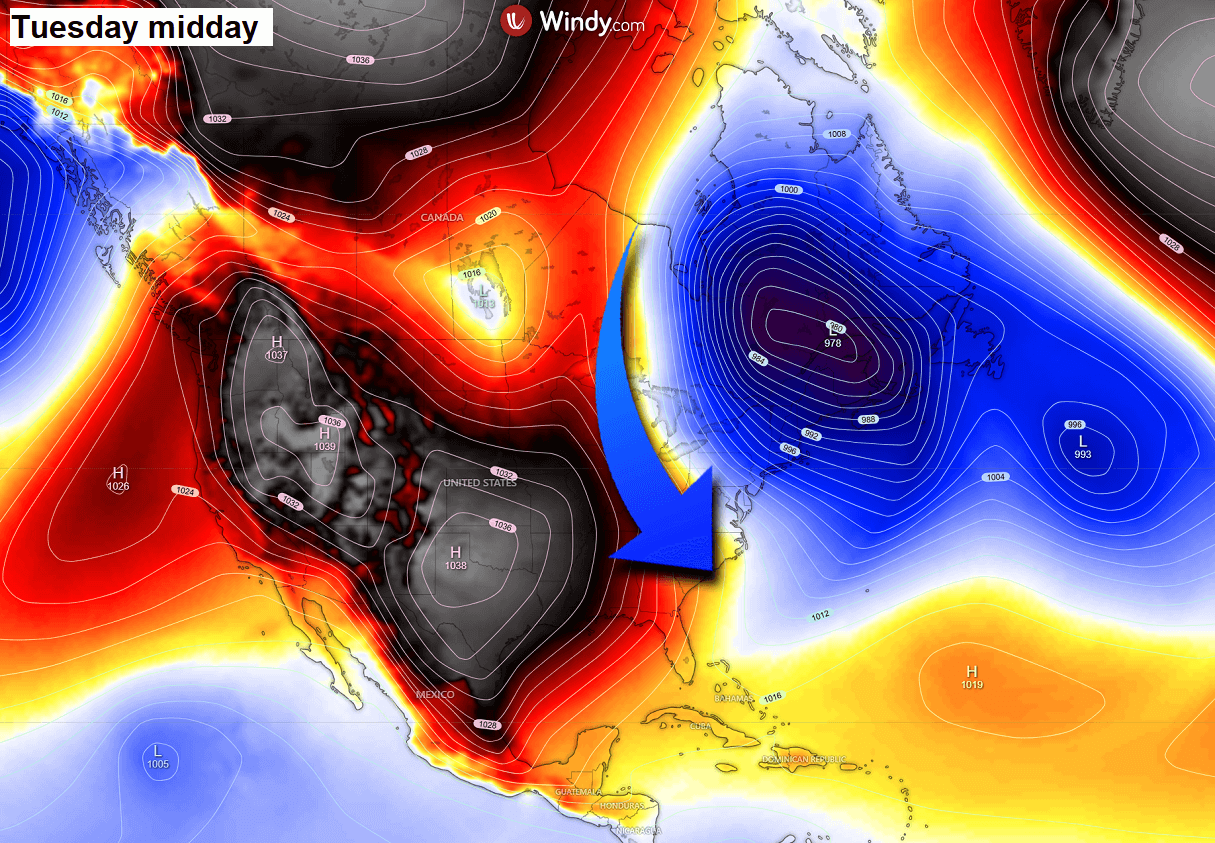
At midday on Tuesday, the bomb cyclone will be fully mature and positioned over eastern Canada, with its central pressure near 978 mbar. A broad surface high-pressure system dominates the west & central U.S., extending into Mexico.
This is creating an open corridor for the Arctic air mass to spread from Canada deep south into the Southeast U.S.
We will get into further details on the cold blast further down below.
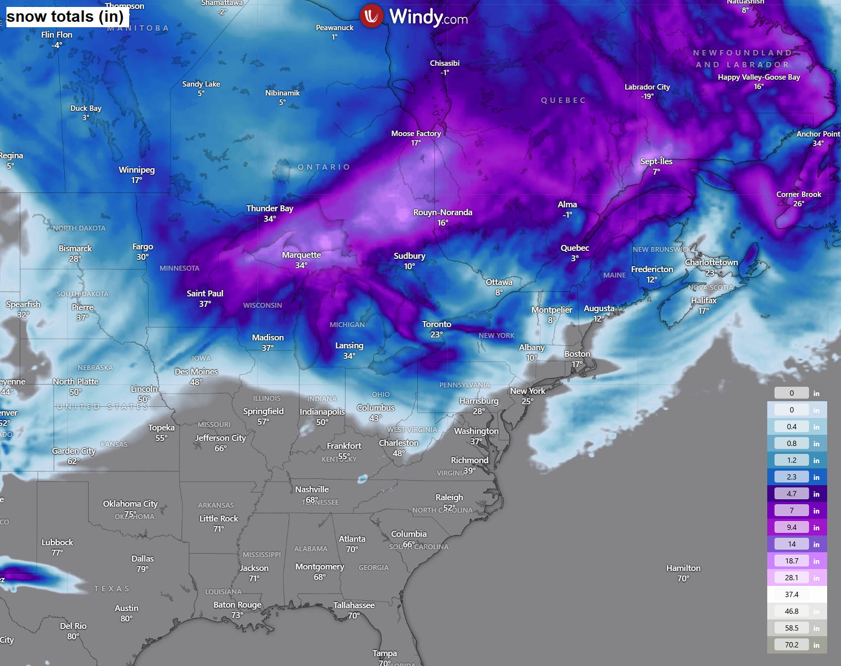
Major Winter Storm Ezra blankets the Great Lakes and Ontario with two feet of snow
As the intensifying bomb cyclone continues through Sunday night, Winter Storm Ezra will form over the Midwest and the Great Lakes. Weather conditions will deteriorate rapidly through Monday as the storm matures over the Lakes.
While the warm advection ahead of the low will temporarily warm the air mass, a sharp, fast-moving cold front will flip the weather back into wintry mode as Arctic air arrives. Intense snow blizzard conditions will develop across the Upper Midwest, the Great Lakes, and Ontario through the afternoon and Monday night.
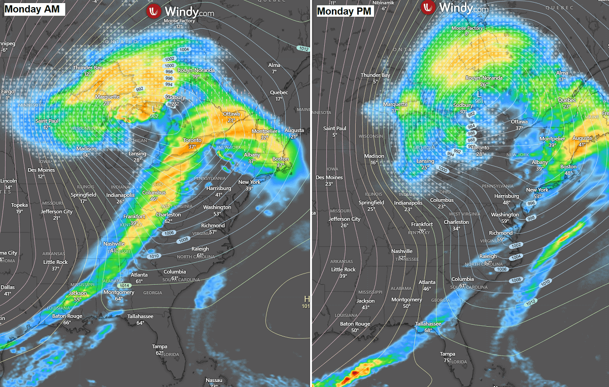
The worst impact of the storm will likely be from southern Minnesota across Wisconsin to Ontario, near and to the north of the cyclone’s core. 20-30 inches of snow is forecast, combined with severe winds, extreme blizzards, and whiteout conditions.
Roads will quickly become impassable, significantly disrupting travel. Heavy snow will also continue east with the storm across Atlantic Canada into Tuesday.
The wind field around the Winter Storm will be intense, thanks to strong pressure and temperature gradients as the bomb cyclone matures over the Great Lakes. Strong to locally severe winds are expected, peaking above 70 mph.
This, combined with heavy snow, will create extreme blizzard conditions and whiteouts, disrupting transportation.
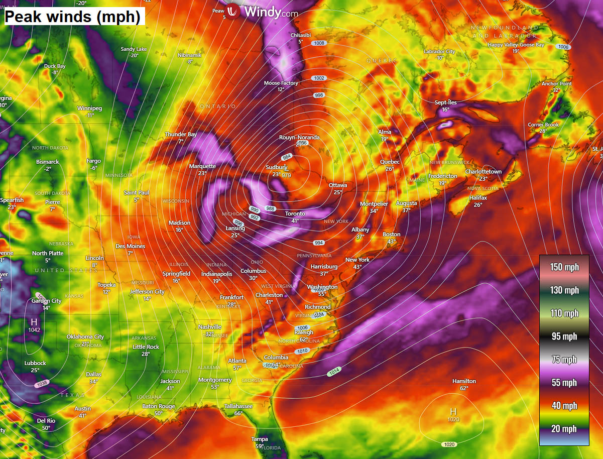
Winds turning to northwesterly will also begin a long-lasting lake-effect snowfall downwind of Lakes Michigan, Ontario, and Erie, starting Monday night.
15-30+ inches of snow could accumulate through the New Year, as northwest winds are forecast to persist, with a new Arctic air mass arriving as January starts on Thursday.
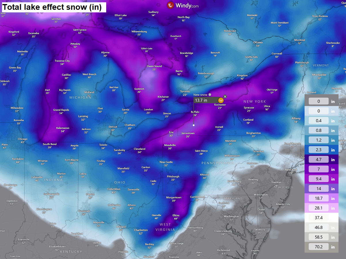
Some snow is also forecast across the western Appalachians and the Ohio Valley due to orographic snowfall from northwesterly winds on the edge of the deep low over the Great Lakes.
A Powerful Arctic cold blast follows into the Southeast U.S. behind the Winter Storm Ezra
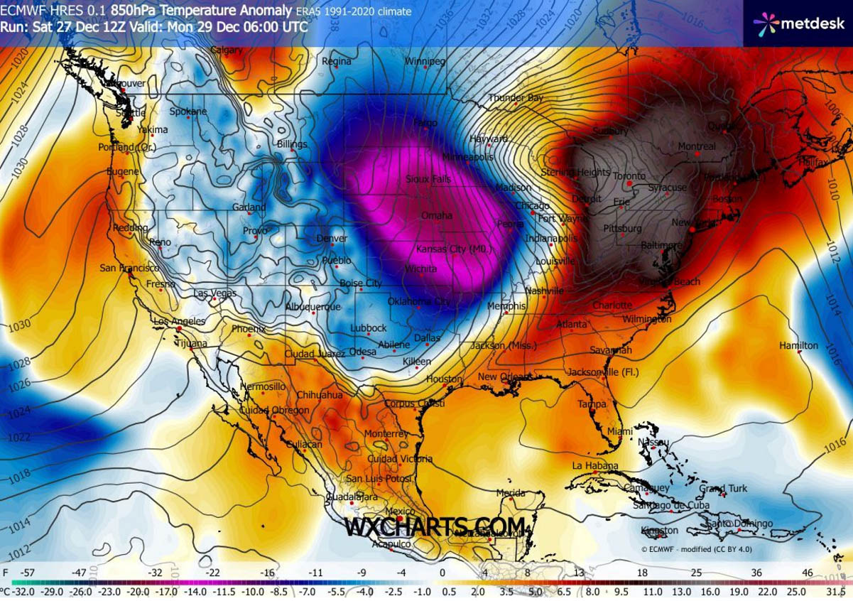
There will be a sharp temperature contrast between the Northeast U.S. and the Central U.S. as the Arctic front blasts in Sunday night. While the Northeast will have temperatures 30+ °F above normal, those will be more than 30 degrees F below normal to the west.
Creating an impressive temperature gradient across the nation, as well as powerful winds in between across the Midwest and the Great Lakes. The Polar air will be rapidly plunging south with the Arctic front.
Much colder temperatures will reach the Southeast U.S. by Monday evening, continue towards the Gulf Coast and Florida Monday night. Reaching South Florida by Tuesday morning.
The Arctic front will be racing across the nation; therefore, expect temperatures to plummet by 30-40 degrees F within a few hours along and behind the front. Tuesday will bring them 20-25 °F below normal.
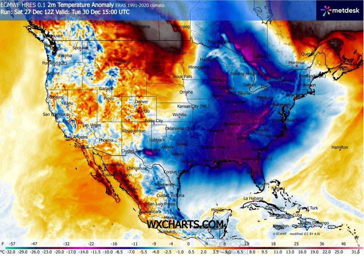
The core of the most significant cold anomaly will be over the Northeast U.S. and the Mid-Atlantic on Tuesday, with temperatures around 25°F below normal for 100+ million people in the region. Including Washington D.C., New York City, Boston, Pittsburgh, and Baltimore. As well as Detroit and Toronto, Canada.
As the Arctic front reaches the Deep South, a significantly colder air mass will also spread towards the western and central Gulf Coast Monday night into Tuesday.
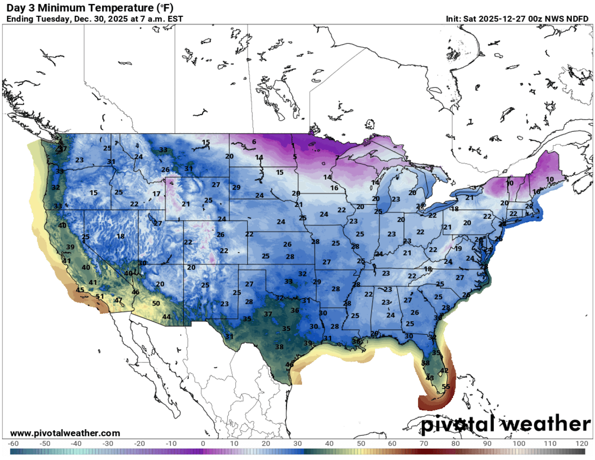
So, Tuesday morning temperatures will be the lowest this week for much of the U.S., while Monday will bring extreme, frigid cold to the northern States, with morning lows below -5 °F.
Elsewhere on Tuesday, most of the lower 48 will experience below-freezing temperatures, with generally upper 10s to low 20s across most states, except for part of Texas, south-central Florida, and the West. Central Florida will push Tuesday’s lows into the upper 30s.
Wednesday will bring some relief from the west as the deep low on the Northeast vanishes, but it will remain extremely cold across the Upper Midwest, the Great Lakes, and the Northeast as a new Arctic blast arrives for the New Year.
Polar Vortex drags another brutal cold blast into the Northeast U.S. for the New Year
The weather pattern over North America locks in as the New Year arrives, meaning more Arctic cold will follow through early January. A strong dipole develops, with persistent blocking High on the West and a large deep trough across the Northeast U.S. and Atlantic Canada on New Year’s Day.
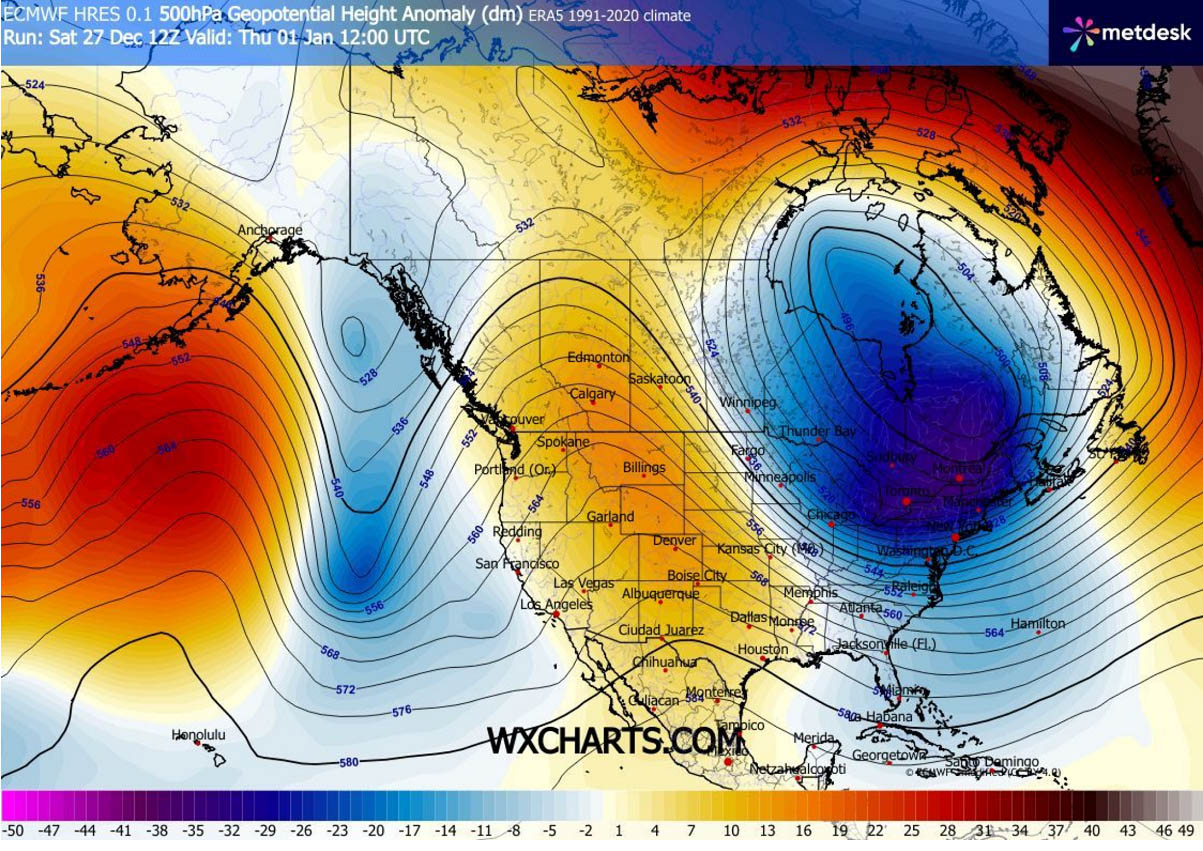
Establishing an undisturbed corridor for meridional flow to deliver more frigid cold, Arctic air mass towards the south.
Weather models are in good agreement that it will remain extremely cold for New Year’s Eve into the following weekend, with temperatures 20-30 °F below across Ontario, the Great Lakes, and the Northeast U.S.
Maintaining the surface temperatures in the deep freeze for days, from Minnesota and Wisconsin to Illinois and Indiana across the Ohio Valley and the Great Lakes to the Northeast U.S.
Temperatures will remain around 20-30 °F below normal through early January, with strong winds, and wind chill temperatures will be close to -50 °F over the broad region.
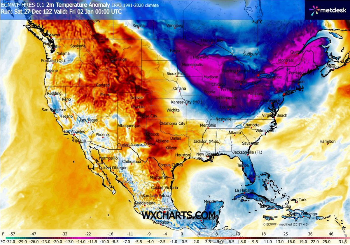
Some temperature relief will follow further west, as the western ridge expands over the Rockies into the Plains. But the deep troughs will remain, plunging new cold outbreaks into the Great Lakes region.
We continue monitoring the pattern, so stay tuned for further updates.
We appreciate the feedback from each of our readers, so please take 2 minutes to complete our new user survey. This will help us learn what you love about our site and what we need to improve, to create even better content for everyone.
Severe Weather Europe Quick User SurveyAs a thank you for sharing your thoughts, you can enter our giveaway in the survey and win one of five SWE rewards, including the brand-new ‘Pursuit of Power’ Severe Weather Calendar 2026.
Windy and Wxcharts provided images used in this article.
See also:
Brace for a chilly start to 2026: PV spčlit prolonged cold to North America and Europe