Weekend temperatures are set to tumble again with rain turning to snow
17:00, 06 Jan 2026Updated 17:55, 06 Jan 2026
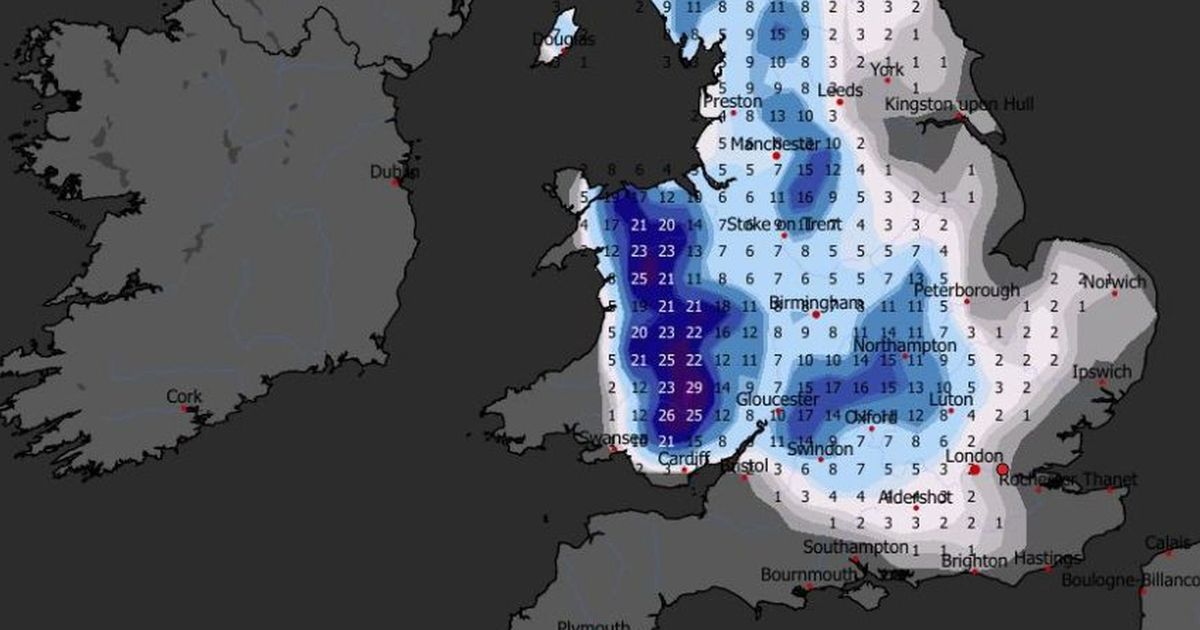
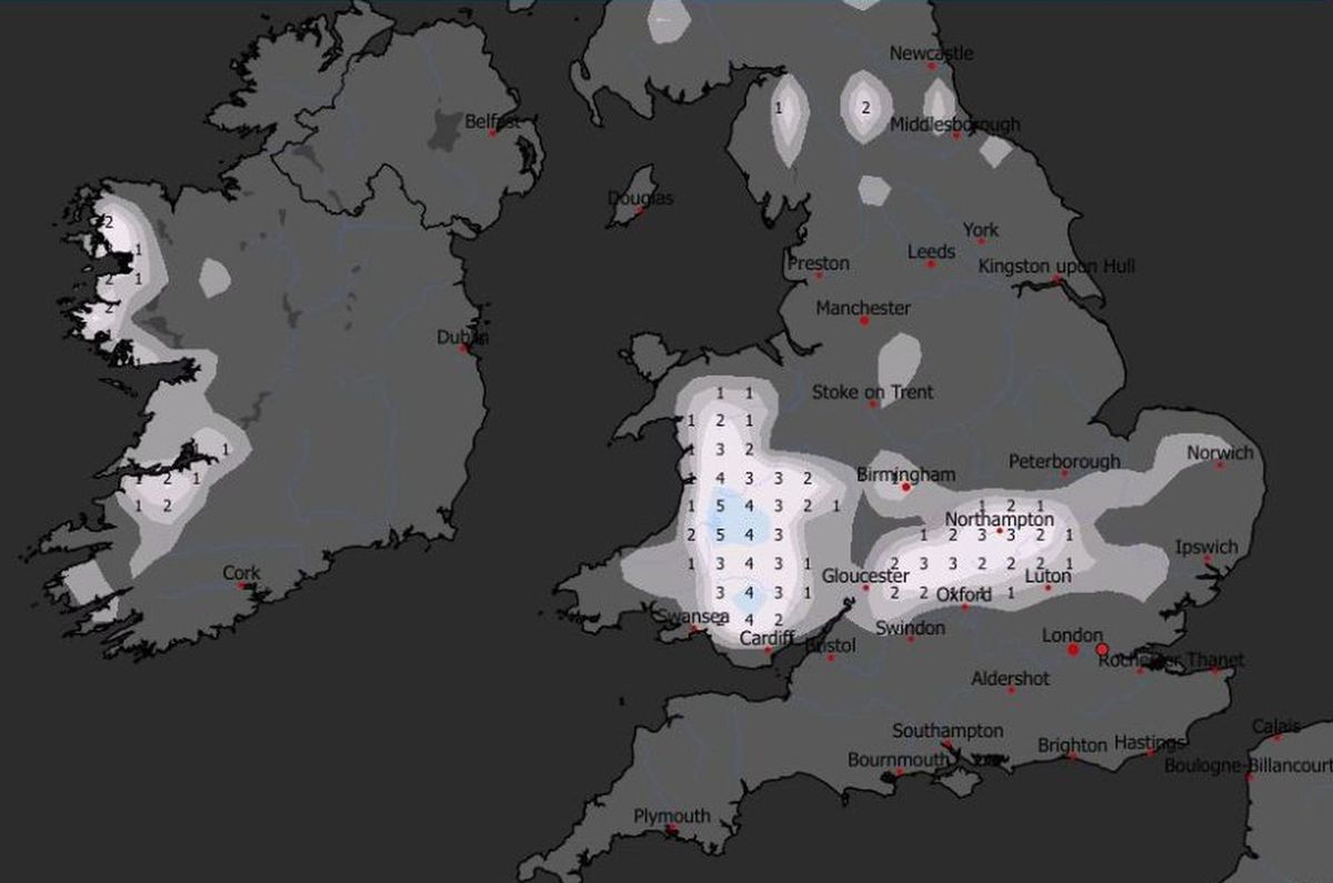
 ECM forecast of total snowfall accumulations between Thursday and Sunday, January 8-11(Image: WXCharts)
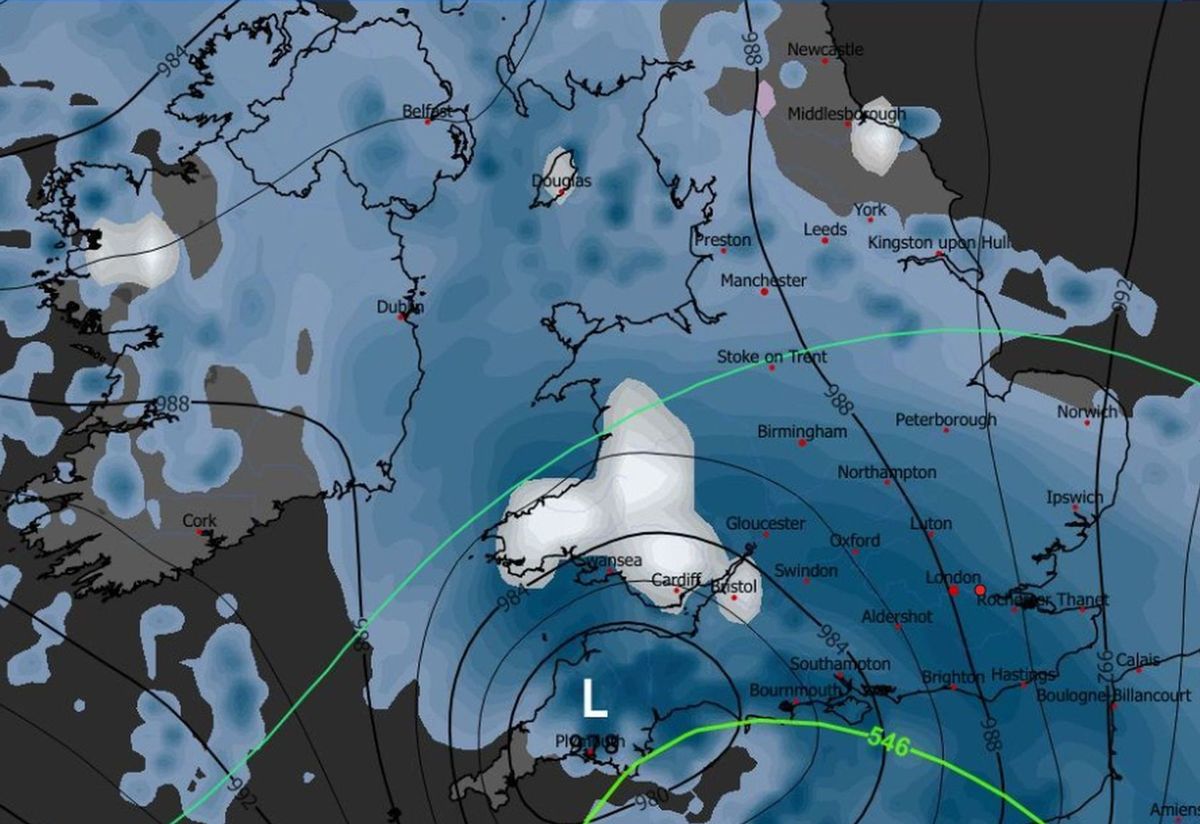
Another snowfront could be set to move across Wales in the wake of Storm Goretti. Weather models show a second Atlantic low moving across the country on Sunday, January 11, dropping more snow as it bumps into cold air.
Where it falls on existing accumulations, significant snow depths are possible – the European ECM model is predicting up to 29cm in parts of Mid Wales between Thursday and Sunday, January 8-11. With next week forecast to be milder, rapid snow melt is expected, possibly leading to local flooding as more bands of rain arrive.
The Met Office has issued a yellow alert for snow from Thursday evening, when Storm Goretti is forecast to make landfall – there’s more on this here. Highest overnight snowfalls totals are expected in South Wales and eastern parts of the country.
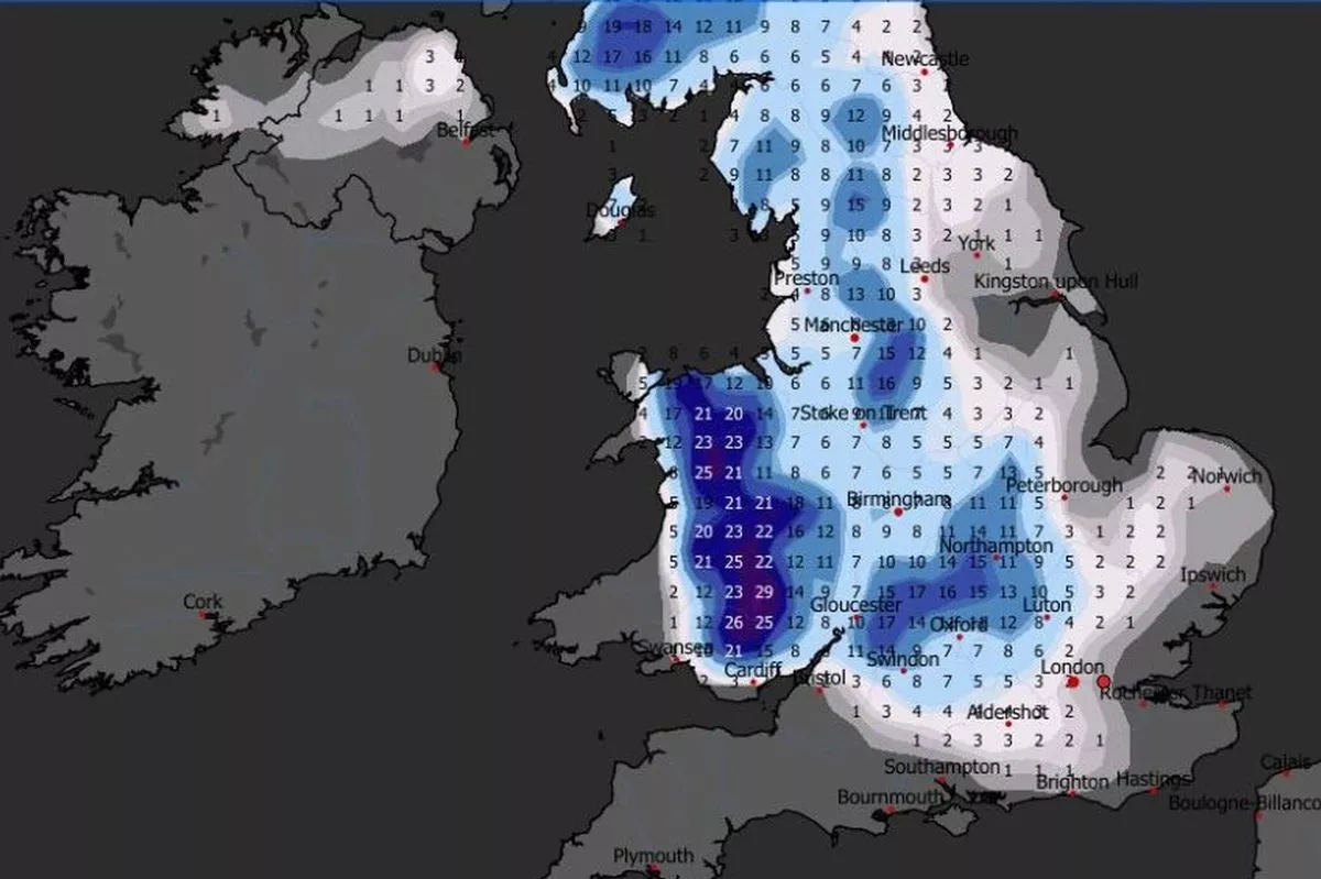
Sunday’s low is less intense but the focus this time may be on North Wales – though the low’s track might change in the interim. By Monday morning, total snow accumulations in Eryri (Snowdonia) could reach 25cm, with lesser snowfalls on lower ground.
The Met Office said the weekend’s weather could be “disruptive”. Temperatures are likely to be well-below average into the weekend, with wintry showers and ice a hazard in places on Sunday.
Rain arriving from the west could potentially turn to snow, with strong winds also a possibility. This will usher in milder air, bringing an end to the current cold spell. Join the North Wales Live Whatsapp community now
In its medium-range UK outlook for Saturday to Monday, January 10-19, the Met Office said: “A changeable period is expected, with Atlantic frontal systems occasionally affecting the UK, bringing spells of rain, probably preceded by snow in some areas.”
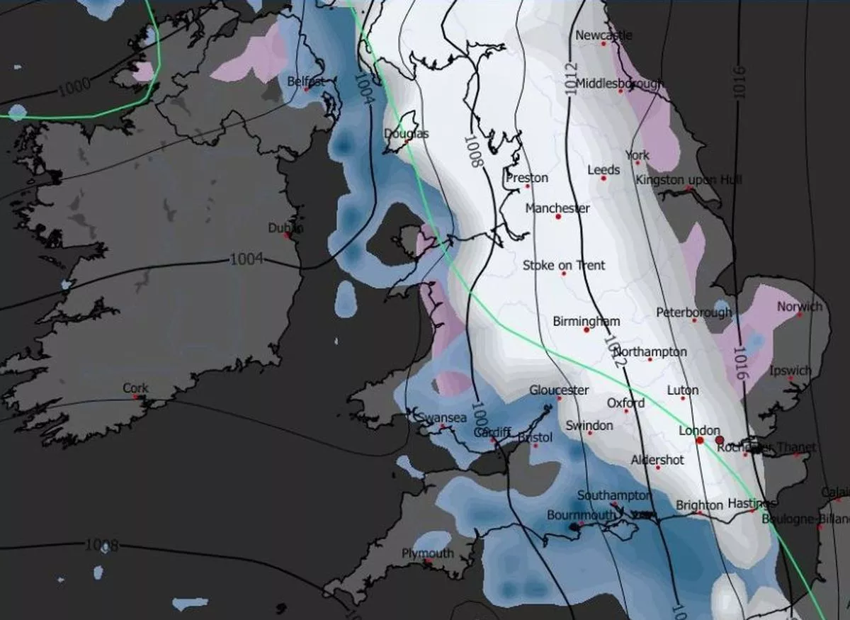 Sunday’s rain is expected to fall as snow on its leading edge(Image: WXCharts)
The Met Office added: “Some significant snowfall is possible in places, particularly on northern hills. These low pressure systems could also bring some strong winds.
“These will be interspersed with quieter, drier interludes under transient ridges of high pressure, with the potential for frost, and wintry showers along coasts exposed to northerly winds.”
“After a cold start (to the period), temperatures will tend to trend closer to average, especially in the south, such that the frequency of wintry hazards may reduce slightly.
“However, there is a hint late in this period that it may briefly turn more widely drier and colder again.”
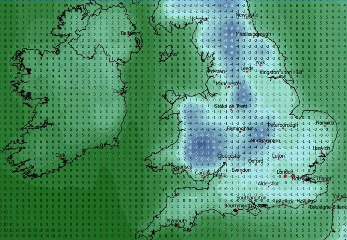 GFS forecast of freezing temperatures on Sunday morning, January 11(Image: WXCharts)
Forecasters are watching out for signs of this mid-January cold spell. Weather models diverge on this issue – but there are signals of high pressure building north of the UK over Scandinavia and eastern Europe, potentially introducing colder conditions again.
As things stand, the Atlantic will still having an influence, bringing success bands of rain across the UK. If temperatures fall, this could yield more snow in the week starting January 19.
In weather terms, this is a long way off, and there’s a good chance the outlook will change in the interim. However some online forecasters detect signals of a blocking high from mid January, potentially causing extreme cold to feed across the UK from the east.
 A mixture of rain and snow is currently forecast for Monday, January 19, as another Atlantic low tracks across Britain(Image: WXCharts)
Weather Trends cautioned against reading too much into the forecast at this stage. But if it materialises, the online forecaster said: “This would not be your “run-of-the-mill” cold snap. This would be high-end winter cold.
“If this evolution came off, it would be on a completely different level to what we’ve seen so far this winter.”
In its long-range UK outlook for January 20 to February 3, the Met Office agreed there was a chance the period may start off dry and cold, with snow and ice possible in central and northern parts of the UK.
However the national forecaster said the likelihood of this happening is lower that what we’ve already seen in January.
 Modest snow depths are forecasted by the ECM model for Monday, January 19(Image: WXCharts)
Nevertheless, the weather outlook for late January remains “very uncertain”, said the Met Office.
“A broadly westerly regime seems more likely than not,” it suggested. “As such, conditions are most likely to be changeable.
“Spells of wet, windy and mild weather are likely at times, along with some colder, drier interludes with overnight frost and fog.” Sign up for the North Wales Live newsletter sent twice daily to your inbox
Find the weather forecast where you live