Meteorologists call Storm Goretti a ‘weather bomb’ – here is what this means
Meteorologists from the Met Office and BBC Weather have now described Storm Goretti as a “weather bomb” as it brews above the Atlantic, primed to target the UK and France.
“Weather bomb” is the unofficial term for ‘explosive cyclogenesis’ where the central pressure of a storm drops by more than 24 millibars in 24 hours.
BBC Weather meteorologist Simon King said: “For Goretti, we’ll see a pressure drop of 36 millibars in the 24 hours from 6pm Wednesday to 6pm Thursday. Therefore, meeting the ‘weather bomb’ definition.”
A weather bomb can bring winds strong enough to bring down trees and cause structural damage, which peak over a period of a few hours.
It’s caused by rapid acceleration of air caused by the jet stream, high up in the atmosphere, can remove air from the column which causes the pressure to drop at sea level, according to the Met Office.
This in turn sucks in air which converges from surrounding regions resulting in faster and faster rotation of the circulation.
Bryony Gooch8 January 2026 09:53
Ferries cancelled and rescheduled as Storm Goretti approaches
Travel correspondent Simon Calder reports:
The Thursday evening round-trip on Stena Vinga between Portsmouth and Jersey has been cancelled. Brittany Ferries’ afternoon sailing from Portsmouth to Caen is leaving 90 minutes early today to avoid the worst of the storm, with cancellations between Poole and Cherbourg on Friday.
Irish Ferries has brought forward several sailings between Holyhead and Dublin, and some of its Dover-Calais ferries on Friday are delayed or cancelled.
Northlink, connecting mainland Scotland with Orkney and Shetland, warns of “the possibility of disruption to our services from Friday 9 January 2026 through to Monday 12 January 2026”.
On Caledonian MacBrayne to and from the Western Isles, the main problems appear to be technical issues on the fleet, affecting links from Oban to South Uist and Mallaig to Armadale.
Bryony Gooch8 January 2026 09:39
Full list of all UK schools closed today as UK braces for Storm Goretti
Bryony Gooch8 January 2026 09:22
In pictures: Alford, Aberdeenshire, snowed under (Dr Graeme Stewart/PA Wire)
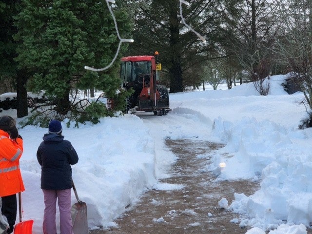 (Dr Graeme Stewart/PA Wire)
Bryony Gooch8 January 2026 09:12
What weather warnings are in place across England and Wales?
Yellow snow warning in the Midlands, the East of England, South East England, the North of England, the South West of England and Wales: Storm Goretti is expected to bring heavy snow. Whilst not all areas may see accumulating snow, accumulations of 5-10 cm are likely quite widely, with scope for 15-25 cm in places, especially on some hills above 200 metres elevation. There is a chance of 30 cm accumulating over high ground in Wales and/or the Peak District.
Yellow rain warning in Yorkshire and the East of England: From 6pm today until 9pm tomorrow, heavy and persistent rain may lead to some flooding and disruption. 20-30 mm rainfall is likely quite widely, with a small chance of 40-60 mm in a few places, and strong winds, especially near coasts, will be an additional hazard with winds gusting 40-50 mph at times and leading to large waves through Friday.
Yellow rain warning in Wales: From midday today until 10am tomorrow, Storm Goretti will bring a spell of heavy rain and hill snow. Rain accumulations of 20-40 mm are possible, with perhaps as much as 60 mm in a few places. This, combined with snow melt, may lead to some surface water flooding.
Amber snow warning across the Midlands, Wales, Yorkshire and Gloucestershire: From 8pm today until 9am tomorrow, rain associated with Storm Goretti will turn readily to heavy snow. Accumulations of 10-15 cm are likely fairly widely, with the potential for 20-30 cm in some locations, mainly on hills above 200 m elevation, more especially in Wales and/or the Peak District.
Amber wind warning across Cornwall and the Isles of Scilly: From 5pm today until 11pm, Storm Goretti may bring a spell of very strong winds for a time with a risk of damage and disruption. Flying debris is likely and could lead to Injuries or danger to life with peak gusts potentially of 80-90 mph in exposed areas.
Yellow snow warning in Devon and Somerset: From 8pm tonight to 9am on Friday, rain associated with Storm Goretti will likely turn to snow in places through Thursday night, persisting for several hours before turning back to rain. Accumulations of 2-5 cm are expected above 200m elevation, with perhaps as much as 10 cm on the highest ground of Dartmoor and Exmoor. The rain, sleet and snow will gradually ease into Friday morning.
Yellow wind warning in the south east and south west of England and Pembrokeshire: From 3pm today until 6am tomorrow, Storm Goretti will bring a spell of strong winds with peak gusts of 50-60 mph likely fairly widely, and 60-70 mph along exposed coasts and hills. Winds will gradually ease through the early hours of Friday.
Bryony Gooch8 January 2026 09:03
‘Consider if your journey is essential’ warns Traffic Wales
Travel correspondent Simon Calder reports:
The AA warns of “hazardous travel likely throughout Thursday night into Friday”. Snowfall combined with gusty winds can reduce visibility in seconds.
The motoring organisation says: “In some areas, 5-10 cm of snow may settle with the potential for up to 20 cm in some locations, especially over higher ground. Strong winds may lead to some drifting of snow.
“Typically in conditions such as these, the AA sees a surge in callouts of around 40-50 per cent.”
Roads across the hills in Wales will be treacherous, and some may be closed. Traffic Wales warns: “Consider if your journey is essential or can it wait until the weather improves. If it is, follow your local police advice, check the weather forecast, and consider if you can take alternative travel such as public transport.
“The stopping distance in icy conditions is ten times more than in dry conditions. Main roads are more likely to have been gritted so will likely be safer to drive.”
Morning rush-hour motorists are facing serious problems on two key routes. The M1 is blocked northbound in Leicestershire after an accident. In Cheshire, the M56 has lanes closed westbound due to emergency repairs.
Bryony Gooch8 January 2026 08:56
Watch: Polar bears enjoy playing in the snow as parts of Scotland are blanketedWatch as Polar bears enjoy playing in the snow as parts of Scotland are blanketed
Bryony Gooch8 January 2026 08:39
‘Travel early in the day to avoid closures later on’ say rail firms
Travel correspondent Simon Calder reports:
Rail passengers are waking up on Thursday morning to a barrage of warnings – including line closures taking place during the afternoon.
Northern says the line between Sheffield and Manchester, as well as routes to Glossop and Buxton, will be closed from 6pm today until Saturday morning.
Tricia Williams, managing director at Northern, said: “We have issued ‘Do Not Travel’ warnings on these three routes and are advising customers to check before they travel on other routes across our network and allow extra time for their journeys.
”The final train from Manchester Piccadilly to Sheffield leaves at 4.48pm, and in the opposite direction at 5.14pm.
Transport for Wales says six lines will be closed completely from 3pm today, with a reduced service on the remainder. The standard advice from TfW is: “You cannot travel – there are no trains running and we are unable to run rail replacement bus services.”
In Scotland, the northern parts of the Far North line from Inverness to Wick and Thurso remain closed, with some rail replacement buses.
Intercity operators are encouraging passengers to travel earlier in the day.Avanti West Coast is to reduce its timetable from 3pm. Instead of three trains an hour between both Birmingham and Manchester to London Euston, there will be two services – and only one an hour between Liverpool and London.
CrossCountry is cutting back trains from 3pm, and is offering passengers with tickets for Thursday or Friday to travel on any train they like today, or switch to Saturday.
LNER is also urging people with trains scheduled after 3pm on Thursday to travel earlier in the day if they can.
Chiltern urges passengers to complete their journeys by 8pm on Thursday and warns of reduced services on Friday.
South Western Railway has cancelled seven long-distance trains on Thursday evening and warns further disruption is likely.
Bryony Gooch8 January 2026 08:24
What weather warnings are in place in Scotland and Northern Ireland?
Yellow snow and ice warning in Scotland: Started on 10pm Wednesday and will continue til midday today as ice is expected to develop overnight. Snow showers will fall to low levels at first away from coasts before becoming confined to ground above around 300 metres. Around 2-5cm of fresh snow accumulations are expected in western Scotland and hills northern England.
Yellow ice warning in Northern Ireland: Started at midnight and will continue til 10am today as an ice risk develops overnight, especially on untreated surfaces. A few showers will also persist across counties Antrim, Derry, Tyrone and Fermanagh, adding to the ice risk in these areas with rain falling on frozen ground.
Bryony Gooch8 January 2026 08:01
Mapped: Where in the UK is under a weather warning today?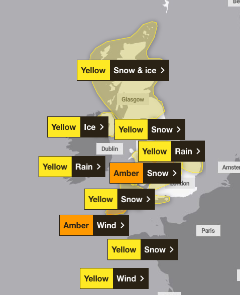 (Met Office)
Bryony Gooch8 January 2026 07:39