
Wales is set to enjoy warm and sunny conditions later this week after a spell of rain and thunderstorms today. On Monday, May 12, the Met Office issued a yellow thunderstorm warning for parts of Wales, central and southwest England, in place until 10pm.
Conditions have been dry with sunny spells elsewhere, feeling warm for many and muggy in the south. Tonight, any showers or thunderstorms will ease and it will leave a largely dry night, with some clear spells according to forecasters.
From Tuesday, May 13 onwards, the outlook improves significantly as high pressure is set to build, bringing more settled weather to much of Wales, with a general trend towards drier, brighter conditions and temperatures in the early twenties. For our free daily briefing on the biggest issues facing the nation, sign up to the Wales Matters newsletter here
READ MORE: US warplane seen tearing through sky over Wales
READ MORE: ‘Breathtaking’ giant sun to come to Wales in special event
Tuesday will see a mix of sunny and cloudy conditions, but by Wednesday there will be more steady sunshine in most parts of Wales every day until next week on Monday, May 19.
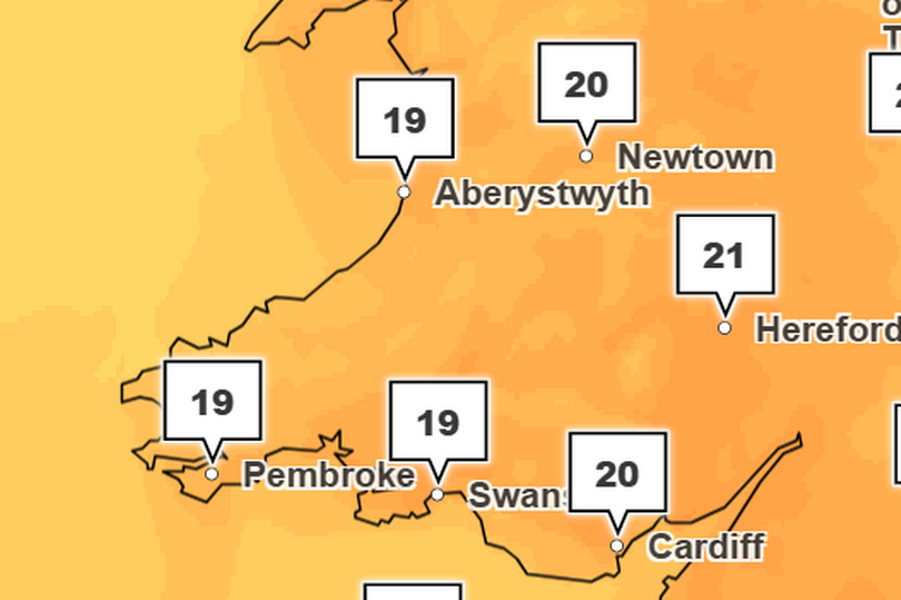
By Thursday, May 15, temperatures are forecast to range from around 19 to 21°C in Wales -Credit:Met Office
By Friday, May 16, temperatures are forecast to peak again around 20 to 21°C especially in central and southern parts of the country by the afternoon.
The improvement in weather is expected to last into the weekend, making it a good opportunity for outdoor plans.
It will become a little cooler despite the sun still being out at the weekend, with most parts of Wales reaching around 17 to 20°C on Saturday and Sunday.
Met Office deputy chief meteorologist Dan Harris said: “Although a few showers are possible over southwest England and South Wales on Wednesday, high pressure will be firmly back in charge bringing settled, dry, and for the vast majority warm and sunny conditions for the remainder of the week.
“Daytime temperatures will be well above average away from the coast, with low to mid 20°s Celsius across many central, southern and western areas.
“Temperatures will be cooler near North Sea coasts, and the extreme north of Scotland with some cloud at times.
“Overnight, clear skies will mean we can expect some chilly nights too.
“The settled weather is expected to continue into the weekend too as high pressure remains centred over the UK, although cloud and early mist will probably become a bit more widespread, this gradually retreating back to coasts through the course of the daytime.
“We will of course keep you updated as the week progresses via our latest forecasts on our website, app and socials.”