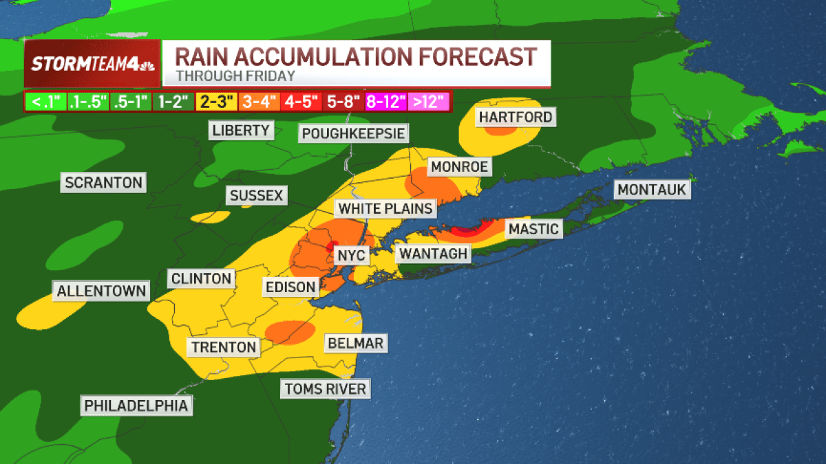
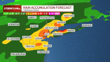
New York City’s second heat wave of summer 2025 is in the books, as attention turns to a Thursday afternoon storm threat that could wreak flood havoc, with rainfall rates exceeding 2 inches an hour possible at times.
Humidity will be lower than earlier in the week, mitigating the threat of severe weather, but these showers will tap into deep atmospheric moisture, producing very heavy rain and heightened flash flooding concerns.
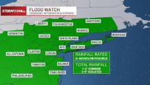
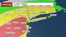
A flood watch has been issued for the entire tri-state area, with forecasts showing a high likelihood of flooding in parts of New Jersey and New York, including the city. Check the latest weather alerts for your neighborhood here.
Two weeks ago, vehicles were stranded, and two people died, when flash floods tore through parts of northern New Jersey. In Manhattan, water gushed in subway stations like waterfalls. Central Park broke a daily rainfall record that had stood for over a century in the span of 60 minutes, as the city recorded more rainfall in a few hours than typically falls in all of July.
New York City saw the rainiest hour in its recorded history from Monday’s storms, leaving roads and some subway stations submerged. But the MTA said they were not to blame for flooding inside the system. In New Jersey, two women were killed as a result of the flooding, and now communities are left to clean up from the damage and debris left behind. NBC New York’s Adam Harding, Andrew Siff, Chris Glorioso and Sarah Wallace have team coverage.
Storms move in after lunch, stay strong through evening
Storms start pushing into the Hudson Valley during the afternoon and by peak commute time, they will be right over the city, delivering robust rainfall. Expect flooding on roadways and low-lying areas, a mess for rush hour.
The worst of the rain will push offshore overnight into Friday morning, with some showers lingering into the first half of the day.
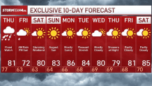
Once these storms move out, there will be a palpable shift in our weather. We’ll see temperatures and humidity drop throughout the day on Friday, as we spend most of the afternoon in the low 70s, even upper 60s, facing a brisk NE wind. You may even want to break out a sweater or light jacket; it is going to feel downright cool.
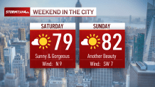
Thankfully, by the weekend, sunnier skies prevail and temperatures rebound just enough to bring back T-shirt weather. And we hold onto the low humidity.
10-day NYC forecast