
 Heavy rain floods NYC area: A look at rescues, damage
Heavy rains flooded many parts of the New York City Tri-State, leading to major transit closures and some damage. FOX 5 NY’s Briella Tomassetti reports on LIRR closures that involved straphangers needing to be rescued, and FOX 5 NY’s Hayley Fixler reports from New Jersey, where several lost power.
NEW YORK – New York and New Jersey saw a deluge of rain when slow-moving storms slammed the area Thursday afternoon, with some localized areas seeing as much as 5 inches of rain in just a few hours.
JUMP TO: NY RAIN TOTALS | NJ RAIN TOTALS | FLASH FLOOD LOCATIONS
According to the National Weather Service, Atlantic City Airport broke records for most rain falling in a single day, at 3.07 inches. In the New York City area, the region as a whole saw 1 to 3 inches, with 3+ inches in parts of Queens and Nassau County and 5+ inches in Suffolk County.
By the numbers:
Here’s a full list of reported rain totals for the region and where flash flooding occurred during Thursday’s storm:
The Bronx Brooklyn
- Prospect Park: 2.37 in
- Brooklyn College: 1.44 in
- Dyker Heights: 1.37 in
- South Slope: 1.24 in
- Brooklyn: 1.12 in
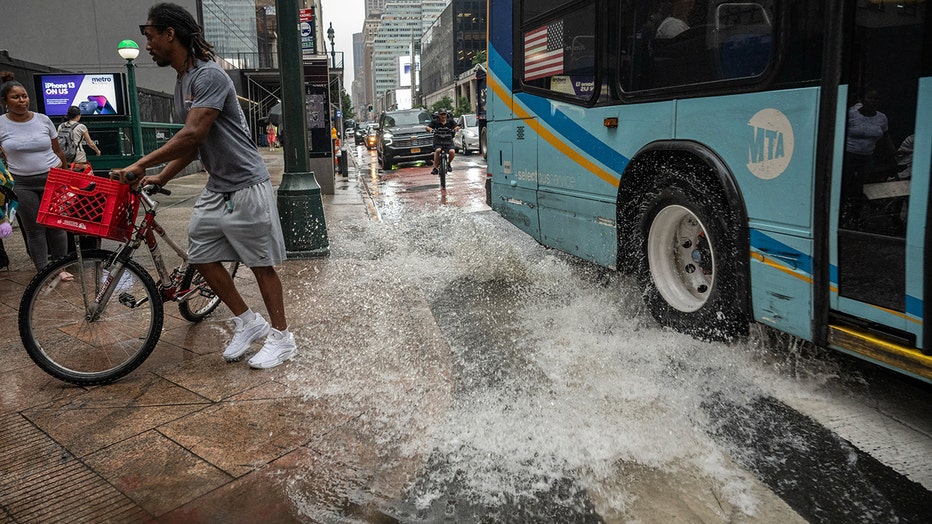
Pedestrians during a rainstorm in New York, US, on Thursday, July 31, 2025. New York City commuters are bracing for potential flooding from heavy rain Thursday, just hours after an unrelated power outage that continued to snarl subways late into the
Nassau County
- Great Neck: 3.08 in
- Merrick: 2.33 in
- Levittown: 2.17 in
- Old Westbury: 1.77 in
- North Massapequa: 1.67 in
- Massapequa Park: 1.61 in
- North Massapequa: 1.59 in
- Bethpage: 1.34 in
- Freeport: 1.33 in
- Massapequa: 1.33 in
- Wantagh: 1.31 in
- Port Washington: 1.30 in
- Hicksville: 1.21 in
- Port Washington: 1.19 in
- East Hills: 1.12 in
- Syosset: 1.04 in
- Branchville: 1.02 in
Manhattan
- Midtown Manhattan: 1.47 in
- Battery Park: 1.17 in
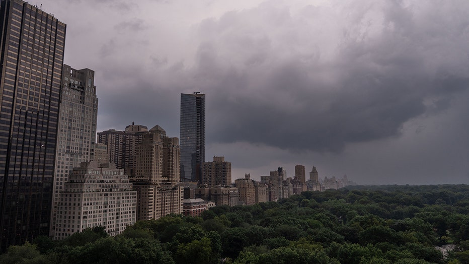
Storm clouds hover near Central Park on July 31, 2025 in New York City. Widespread storms swept across the Mid-Atlantic and Northeast on Thursday, bringing bursts of heavy rain. (Photo by Adam Gray/Getty Images)
Orange County
- Middletown: 2.96 in
- Middletown: 2.53 in
- Walden: 2.48 in
- Montgomery: 2.36 in
- Otisville: 2.28 in
- Port Jervis: 1.94 in
- New Windsor: 1.78 in
- Vails Gate: 1.56 in
- Chester: 1.30 in
- Cornwall on Hudson: 1.27 in
- Newburgh: 1.24 in
- Tuxedo Park: 1.16 in
- Warwick: 1.15 in
- Montgomery Airport: 1.11 in
- Washingtonville: 1.07 in
Queens
- Long Island City: 1.26 in
Staten Island
- Staten Island: 2.66 in
- Westerleigh: 2.66 in
- College of Staten Island: 1.92 in
Suffolk County
- Sayville: 4.54 in
- Islip Airport: 2.85 in
- Shirley Airport: 2.57 in
- Blue Point: 2.47 in
- Patchogue: 2.32 in
- North Patchogue: 2.01 in
- Fair Harbor: 1.91 in
- Shirley: 1.78 in
- Farmingdale Airport: 1.56 in
- Islip: 1.46 in
- Selden: 1.41 in
- Dix Hills: 1.27 in
- Smithtown: 1.21 in
- Amityville: 1.15 in
- Ridge: 1.14 in
- Saint James: 1.12 in
- Stony Brook: 1.08 in
- Miller Place: 1.03 in
Westchester County Atlantic County
- Atlantic City: 3.07 in
- Forsythe: 2.19 in
- Egg Harbor Twp: 2.18 in
- Egg Harbor Township: 2.13 in
- Smithville: 2.12 in
- Mays Landing: 2.11 in
- Mays Landing: 1.87 in
- Atlantic City: 1.81 in
- Mays Landing: 1.65 in
- Brigantine: 1.51 in
- Atlantic City Marina: 1.34 in
- Hamilton Twp: 1.32 in
- Folsom: 1.27 in
Bergen County Burlington County
- Browns Mills: 6.00 in
- Coyle Field: 1.74 in
- Mount Holly: 1.67 in
- Lumberton: 1.48 in
- Mount Holly WFO: 1.48 in
- Tabernacle: 1.32 in
- McGuire AFB: 1.23 in
- Shamong: 1.15 in
- Willingboro: 1.06 in
Camden County Cape May County
- Cape May Point: 2.43 in
- Sea Isle City: 1.48 in
- Ocean City: 1.08 in
Cumberland County
- Bridgeton: 3.41 in
- Millville: 2.14 in
- Greenwich: 1.07 in
Essex County
- Caldwell: 3.20 in
- West Caldwell: 2.30 in
- Montclair: 1.90 in
- West Caldwell: 1.58 in
- Millburn: 1.46 in
- West Orange: 1.46 in
- Montclair: 1.40 in
- Millburn: 1.36 in
- Orange: 1.35 in
Gloucester County
- Logan Township: 2.79 in
- Mullica Hill: 1.71 in
Mercer County Middlesex County
- Sayreville: 2.98 in
- Woodbridge: 1.42 in
- Monroe Twp: 1.25 in
- Carteret: 1.09 in
Monmouth County
- Matawan: 2.40 in
- Keyport: 2.10 in
- Union Beach: 2.01 in
- N. Middletown: 1.94 in
- Clarksburg: 1.13 in
- Manalapan Township: 1.09 in
Morris County
- Randolph: 2.12 in
- Stirling: 1.88 in
- Ironia: 1.76 in
- Mine Hill: 1.76 in
- Long Hill Twsp: 1.42 in
- Pleasant Plains: 1.32 in
- Randolph: 1.13 in
- East Hanover: 1.13 in
- Madison: 1.09 in
- Boonton: 1.06 in
- Whippany: 1.04 in
- Succasunna: 1.01 in
Ocean County
- West Creek: 1.71 in
- Beach Haven: 1.58 in
- Ship Bottom: 1.47 in
- Ship Bottom: 1.47 in
- South Seaside Park: 1.34 in
- Seaside Park: 1.26 in
- Surf City: 1.18 in
- Jackson: 1.12 in
- Lakewood: 1.10 in
- Manchester Twp: 1.01 in
Salem County
- Woodstown: 2.60 in
- Pennsville: 1.29 in
- Pennsville: 1.27 in
Somerset County
- Martinsville: 2.40 in
- Bernardsville: 2.18 in
- Bridgewater: 2.17 in
- Bound Brook: 2.00 in
- Somerville: 1.83 in
- Far Hills: 1.66 in
- Bridgewater: 1.44 in
- Watchung: 1.13 in
- Bound Brook: 1.00 in
Sussex County
- Montague: 4.11 in
- Wallkill River Nwr: 2.77 in
- Walpack Reservoir: 2.61 in
- Stockholm: 1.09 in
- Barry Lakes: 1.08 in
- High Point: 1.00 in
Union County
- Mountainside: 1.92 in
- Bayside: 1.16 in
Warren County
Here’s where flash flooding was reported, according to the NWS:
Suffolk County, Long Island
- 2 NW Shirley Airport: Moriches Middle Island Road flooded in several spots, stretching across the whole road.
- 1 NW North Bellport: Numerous road closures reported from Medford to North Bellport.
- Holbrook: Multiple roads closed throughout Holbrook due to flooding.
- 1 S Bohemia: Video showing an SUV with floodwaters up to the windows in a parking lot.
- 1 NNE Oakdale: Oakdale-Bohemia Rd flooded, with cars unable to pass and some stuck.
- 1 W Sayville: Several feet of water reported at the intersection of Locust Ave and Bourne Blvd.
- West Sayville: Car stuck in floodwaters on Bartley Lane.
Nassau County, Long Island
- 1 WSW Levittown: Video showing feet of water at the intersection of Chimney Lane and Loring Road.
- Russell Gardens: Street covered in feet of water, spilling over onto the LIRR Great Neck train station platform and tracks.
Brooklyn
- 2 N Bay Ridge: Street flooded with up to a foot of water, with sewers pushing water onto the street.
Queens
- Little Neck: Road closure reported; cars stranded in floodwaters on the Little Neck Parkway under the LIE overpass.
- 1 W Bayside: Flooding on I-295 southbound at Belt System – Cross Island Parkway; Throgs Neck Approach, with all lanes blocked.
- 2 SSW Bayside: Large truck partially submerged; all lanes of the Clearview Expressway closed.
- 2 N Fresh Meadows: Flooding on I-295 both directions at Northern Boulevard; NY 25A, with all lanes blocked.
Staten Island
- 1 W Westerleigh: Flooding on I-278 eastbound approaching Lambert Street, with 2 left lanes of 4 lanes closed.
Orange County, NY
- 1 E Montgomery Airport: NY 211 at Dunn Road flooded and not passable.
Essex County, NJ
- 1 NNW Orange: I-280 eastbound with 3 lanes closed due to flooding.
Union County, NJ
- 1 SE Elizabeth: Vehicle stuck in floodwaters under a bridge.
- 1 SSW Roselle Park: W 2nd Ave at Pine St closed due to flooding.
- Summit: Street/road flooding reported; street/road closed and vehicles stranded.
- Westfield: Street/road flooding reported; street/road closed and vehicles stranded.
The Source: This article uses information from the National Weather Service.
Severe WeatherNew JerseyNew York