Today’s weather: Heat builds up before afternoon showers
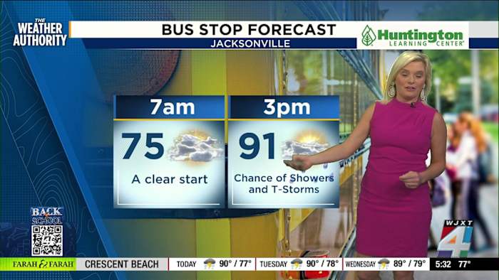
JACKSONVILLE, Fla. – Morning plans in Jacksonville are looking good with dry skies and comfortable temperatures to get the day started. The Weather Authority’s Katie Garner says the morning starts off clear, with temperatures right around 75 degrees at 7 a.m. This comfort won’t last long, though—heat is forecast to ramp up quickly, reaching a high near 91 degrees by 3 p.m. Because of the humidity, it’s expected to feel hotter, with feels-like temperatures approaching 95 to 99 degrees through mid-afternoon.
The Exact Track 4D radar shows only a few light showers near Brunswick during the early morning hours. By the time kids are heading home from school, more widespread moisture is predicted to move in from the Atlantic. The highest risk for showers and some pop-up storms is likely between 3 and 6 p.m., especially in the central part of the Jacksonville area. Although it may be tempting to skip the rain gear, Katie Garner suggests at least packing a poncho, even if it doesn’t end up getting used.
Safety and daily routines: Keeping cool as ‘feels like’ temperatures climb
This afternoon’s heat is not just about the numbers on the thermometer. With humidity factored in, the “feels like” temperature will make it seem as though it’s in the upper 90s to 100-plus across the region, especially by late afternoon and into the evening. Katie Garner recommends staying hydrated and keeping an eye on changing conditions, since showers and thunder could impact the after-school commute and outdoor activities.
For the early risers and morning commuters, calm winds and dry roads are expected to start the day, as confirmed by JAX Airport live cams and wind speed observations. Be prepared for conditions to shift quickly once storms roll in this afternoon.
Rainy season pattern: More storms possible for Jacksonville throughout the week
It’s not just today that’s going to bring wet weather. According to Katie Garner and The Weather Authority’s forecast, afternoon showers and isolated storms are in the mix each day this week. This pattern is typical for a Jacksonville summer, with increased rain chances building through the late afternoon and evening hours. While there’s no flash flood risk expected for most of the Jacksonville area today, heavier rainfall and isolated flood concerns could be something folks in neighboring Georgia see.
Rainfall predictions through the next seven days show a good amount of accumulation on the way—something to keep in mind for anyone with outdoor plans. Stay tuned to News4JAX and Exact Track 4D for the latest updates all week long.
Have weather photos or video of today’s storms or sunshine? Share your day by submitting it to SnapJAX!
Copyright 2025 by WJXT News4JAX – All rights reserved.