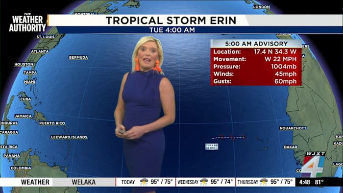
Tropical Storm Erin: All eyes on the Atlantic
JACKSONVILLE, Fla. – The Weather Authority is closely monitoring Tropical Storm Erin as it makes its way across the Atlantic this week. According to Exact Track 4D and meteorologist Katie Garner, Erin is encountering a combination of low wind shear, warm sea surface temperatures, and high mid-level moisture. These factors create an environment that is expected to support rapid intensification, with Erin forecast to possibly become the first major hurricane of the Atlantic season as it nears Puerto Rico by the weekend.
For Jacksonville and the rest of Florida, there is no immediate threat from Erin at this time. Most long-range models suggest the storm will curve northwest and remain well east of the Florida coastline. However, The Weather Authority emphasizes that it’s too early to predict Erin’s ultimate path with certainty and will continue to provide updates as more data becomes available.
Jacksonville’s heatwave continues: Here’s what to expect
If you’ve stepped outside lately, you already know—it’s hot. Temperatures across Jacksonville are starting the day in the upper 70s to low 80s, and they’re only going up from there. The Weather Authority’s latest numbers show daytime highs stuck in the mid-90s from now through Sunday.
The real story, though, is how hot it will feel. The “feels like” temperature during the afternoon could easily reach 105 to 106 degrees, so it’s essential to stay cool and hydrated, especially if you’re spending time outdoors. This challenging heat is sticking around, with only minimal chances for a stray, brief shower—nothing widespread is forecast. The meteorologist notes that any rain showers likely won’t have a major impact on your plans unless you’re caught outside at just the wrong moment.
Back to school: Staying safe in the heat
Bradford County becomes the first in the area to head back to school this week. Other counties are either just starting or have already begun, and it’s important for everyone—especially kids heading out on foot or by bike—to prepare for the lingering heat. Staying hydrated, wearing light clothing, and taking breaks in the shade will be key for a safe and successful return to class.
Stay weather aware with The Weather Authority
While tropical activity in the Atlantic always grabs attention at this time of year, News4JAX’s meteorologist stresses there’s no cause for alarm right now. The Weather Authority will provide regular updates as the situation develops. For now, keep an eye on the forecast, look out for each other in the heat, and remember: The best way to stay informed is to check the latest from News4JAX.
Caught a great weather moment? Share your photos and videos with SnapJAX at https://www.news4jax.com/snapjax/.
Copyright 2025 by WJXT News4JAX – All rights reserved.