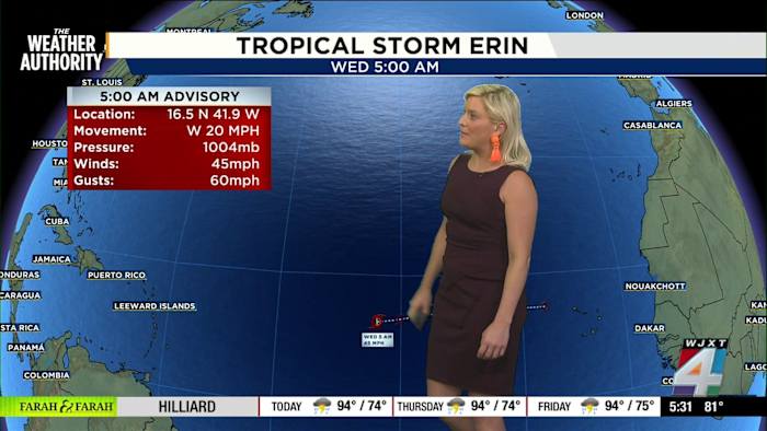
JACKSONVILLE, Fla. – News4JAX is tracking Tropical Storm Erin closely as it’s forecast to become the first hurricane of the Atlantic hurricane season, according to the 5 a.m. advisory from the National Hurricane Center.
By Thursday into Friday, Erin is expected to reach hurricane strength, and by Sunday, it is forecast to intensify further into a Category 3 hurricane.
Erin looks likely to pass by Puerto Rico and the Dominican Republic as it strengthens, but its path beyond that point remains uncertain. Steering patterns and developing weather systems could determine whether Erin turns out to sea or moves closer to the coastline, including the Jacksonville area.
Updates are anticipated in the coming days as The Weather Authority analyzes the latest data and advisories.
We will continue to monitor and update the forecast as it evolves. If the storm’s direction or strength changes, expect more details as soon as they’re available from Exact Track 4D.
Extreme heat continues
Jacksonville is also in for another day of intense heat. The bus stop forecast predicts a clear and warm morning near 80 degrees at 7 a.m., with afternoon temperatures climbing to 94 degrees and a chance of showers or storms by 3 p.m.
But it’s the “feels like” values that will have everyone looking for shade and water — the heat index is forecast to reach 103 to 105 degrees by mid-afternoon.
Remember how important it is to stay hydrated, especially for anyone heading out to school, outdoor events, or sports in this kind of heat.
Also, a quick safety reminder: hot cars can reach around 140 degrees, even if you’re parked for just a short time.
Secondary Gulf system may bring rain
In addition to watching the tropics, The Weather Authority is keeping an eye on a secondary system in the Gulf.
While this area has a 10% to 20% chance of developing, it could act as a rainmaker for parts of the region.
No major impacts are expected in Florida or the U.S. Gulf Coast from this system, but it could develop into a tropical storm or a tropical depression before making landfall in Mexico this weekend.
Share your weather photos
Experiencing this summer heat or watching the skies for tropical changes?
Share your photos and stories with SnapJAX at news4jax.com/snapjax/ for a chance to be featured by The Weather Authority!
Copyright 2025 by WJXT News4JAX – All rights reserved.