Severe thunderstorm and flash flood warnings were issued by the National Weather Service in Phoenix on Thursday, Aug. 14. The warnings apply to Maricopa County.
Meteorologists warn of winds as strong as 60 mph.
Use caution: Officials warn of hail as large as 0.75 inches.
The National Weather Service warns: “For your protection move to an interior room on the lowest floor of a building.”
A severe thunderstorm was located over the Glendale Sports Complex, or near Tolleson, and was nearly stationary with 60 mph wind gusts.
Expect damage to roofs, siding, and trees. Locations impacted include: Phoenix, Glendale, Deer Valley Airport, Arrowhead Mall, and Metro Center. This included the following highways: Interstate 17 between mile markers 209 and 224; Loop 101 between mile markers 15 and 28; State Route 74 between mile markers 28 and 30.
A severe thunderstorm also was located near New River with 60 mph wind gusts. Locations impacted included: New River and Interstate 17 between mile markers 232 and 239.
A severe thunderstorm also was located over Deer Valley Airport, or near Peoria with 60 mph wind gusts. Locations impacted included: Phoenix, Glendale, Deer Valley Airport, Arrowhead Mall, and Metro Center. This included the following highways: Interstate 17 between mile markers 209 and 224; Loop 101 between mile markers 15 and 28; State Route 74 between mile markers 28 and 30.
A storm warning was issued earlier in the night for these affected areas: Surprise, New River, Lake Pleasant, Pipeline Canyon Trailhead, Cottonwood Day Use Area, Castle Creek Boat Ramp, Vistancia, and Anthem.
A flash flood warning also was issued for Maricopa County until 1 a.m. At 10:18 p.m., trained weather spotters reported flooding along Interstate 17 and Happy Valley Road. Thunderstorms were producing heavy rain across the warned area. Between 1 and 2 inches of rain have fallen. Additional rainfall amounts of 0.5 to 1 inch are possible in the warned area.
Life-threatening flash flooding of creeks and streams, urban areas, highways, streets and underpasses is ongoing or expected to begin shortly.
Some locations that will experience flash flooding include: Phoenix, Glendale, Scottsdale, Paradise Valley, New River, Cave Creek, Carefree, Desert Ridge Marketplace, Deer Valley Airport, Scottsdale Airport, Anthem, Vistancia and Lake Pleasant.
See weather radar for metro Phoenix area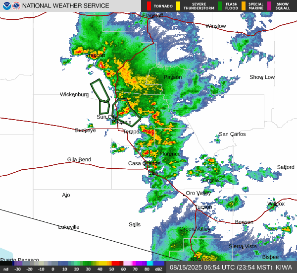 What are weather service meteorologists saying?
At 9:22 p.m., the weather service issued a statement:
“The National Weather Service in Phoenix has issued a Severe Thunderstorm Warning for: Maricopa County in south central Arizona, Until 10:15 p.m. MST. At 9:22 p.m. MST, a severe thunderstorm was located over Pipeline Canyon Trailhead, or 12 miles north of Peoria, moving north at 5 mph.
HAZARD: 60 mph wind gusts.
SOURCE: Radar indicated.
IMPACT: Expect damage to roofs, siding, and trees. Locations impacted include: Surprise, New River, Lake Pleasant, Pipeline Canyon Trailhead, Cottonwood Day Use Area, Castle Creek Boat Ramp, Vistancia, and Anthem. This includes the following highways, AZ Interstate 17 between mile markers 220 and 232. US Highway 60 between mile markers 133 and 137. AZ Route 74 between mile markers 8 and 30.”
What is a severe thunderstorm warning?
A severe thunderstorm warning means the area is experiencing or is about to experience a storm with winds of 58 mph or higher or hail an inch in diameter or larger.
Tips for staying safe during thunderstorms
- Once in a shelter, stay away from windows and avoid electrical equipment and plumbing.
- Keep a battery-powered weather radio nearby in case of loss of power.
- Remember to bring pets inside.
- If there is time, secure loose objects outside as these objects often become dangerous flying debris in high winds.
- Postpone outdoor activities until the storms have passed.
Reporters Jana Hayes and Victoria Reyna-Rodriguez contributed to this article.
This weather report was generated automatically using information from the National Weather Service and a story written and reviewed by an editor.
(This story was updated to add new information.)
See the latest weather alerts and forecasts here