The cold front that’s the game-changer for our weather moves through the Philadelphia area overnight, bringing showers and storms with it. While most of the storms in the area have remained below severe weather criteria, flash flooding continues and will likely impact portions of the area into the wee hours of the morning. Be very careful driving overnight, and DO NOT attempt to drive through flooded roads.
A flood warning is in effect for Philadelphia, Bucks and Montgomery counties in Pennsylvania, and in Burlington and Camden counties in New Jersey until 4 a.m. on Monday.
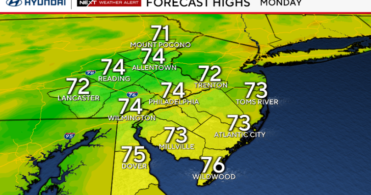
Behind these storms, much cooler air arrives, and we begin the week with highs only in the mid-70s. It will be cloudy with scattered showers on Monday and Tuesday. By Wednesday, some sun returns with isolated thunderstorms and highs near 80.

CBS News Philadelphia
Tracking Hurricane Erin
Erin is now a Category 3 storm, with winds of 125 mph. It will slowly turn northwest, then north, then northeast this week, moving away from the U.S. While we won’t see direct effects such as wind and rain, coastal flooding, dangerous rip currents and tides and beach erosion is likely. A small craft advisory is in effect through the end of the week, for waves 6–12 feet.
By mid to late week, Hurricane Erin will be far offshore and traveling north and along the Jersey Shore. Surf will be high, and rip currents will be dangerous. Stay tuned for more on the hurricane with new updates expected Monday.

CBS News Philadelphia
Here’s your 7-day forecast:

CBS News Philadelphia
Monday: Scattered showers. High 74, Low 71
Tuesday: A stray shower? High 77, Low 66
Wednesday: Late showers? High 80, Low 67
Thursday: Partly cloudy. High 81, Low 68
Friday: Mostly sunny. High 84, Low 65
Saturday: Partly sunny. High 84, Low 65
Sunday: Partly cloudy. High 83, Low 69
More from CBS News