
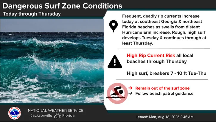
Jacksonville is bracing for dangerous beach conditions this week as Category 4 Hurricane Erin churns offshore. While the storm is expected to remain well out to sea, its powerful swells are already creating deadly rip currents and rough surf along northeast Florida and southeast Georgia beaches.
The National Weather Service has issued a High Rip Current Risk through at least Thursday, with breakers reaching 7 to 10 feet. As reported by First Coast News, Jacksonville Beach Rescue is closely monitoring conditions and urging people to stay out of the water and follow beach patrol instructions.
Dangerous Surf and Turf_8_18_25 week
What’s the latest on Hurricane Erin?
Hurricane Erin intensified on Monday, Aug. 18, and is expected to strengthen further as it threatens the Bahamas and Hispaniola with possible flooding and is forecast to unleash “life-threatening” surf conditions across the eastern U.S. coast this week.
After losing some power over the weekend, the hurricane strengthened back into a Category 4 storm with maximum sustained winds of 130 mph overnight, according to an 8 a.m. ET advisory from the National Hurricane Center. Forecasters show the storm intensifying more as it gradually turns north on a path between the U.S. and Bermuda.
Hurricane Erin has reintensified into a Category 4 storm on Monday, Aug. 18, according to the National Hurricane Center.
What will be Erin’s local impacts in Jacksonville this week?
Here’s a breakdown of daily local impacts by Erin this week:
According to the National Weather Service, a High Rip Current Risk is in effect through Thursday, posing a significant danger to swimmers and beachgoers. From Tuesday through Thursday, rough and high surf conditions are expected, which will further increase the risk of rip currents and make coastal waters hazardous. Additionally, a Small Craft Advisory is in place from tonight through Friday, warning boaters of potentially dangerous conditions at sea due to strong winds and elevated wave heights. Caution is strongly advised for anyone planning to be in or near the water during this period.
Thunderstorm and shower advisories for Jacksonville this week. What to know
Expect daily rounds of showers and thunderstorms this week, with the potential for heavy rain and strong storm hazards. This morning, localized flooding is a concern along coastal northeast Florida, while inland areas could see heavy downpours and flooding later this afternoon. Some storms may bring gusty winds and frequent lightning strikes, and there’s also a chance for waterspouts to develop along the Atlantic coast. The NWS is advising to stay weather-aware, especially during peak storm times.
What are the Marine & Surf Zone conditions in Jacksonville this week?
Here’s a list of the dangerous marine and surf zone conditions to be aware of in Jacksonville beaches:
-
High Rip Current Risk at All Local Beaches through Thursday
-
High Surf & Beach Erosion at the Northeast FL Beaches Tuesday – Thursday
-
Minor Coastal Flooding Possible Around Times of High Tide from Wed – Thurs
-
Small Craft Advisory Tonight – Friday
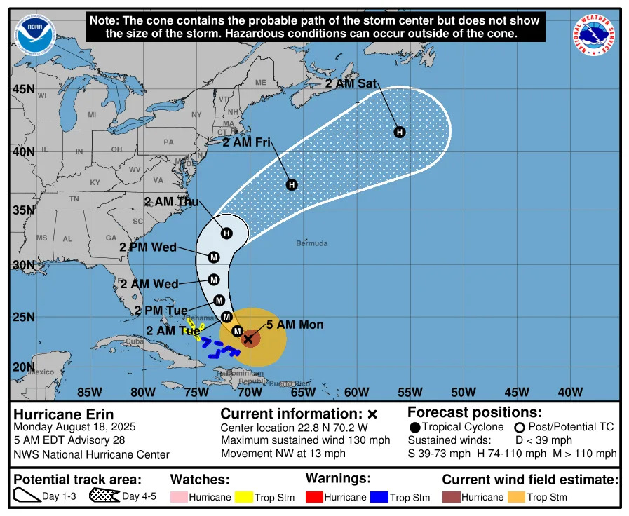
Hurricane Erin path tracker
This forecast track shows the most likely path of the center of the storm. It does not illustrate the full width of the storm or its impacts, and the center of the storm is likely to travel outside the cone up to 33% of the time.
Hurricane Erin spaghetti models
Illustrations include an array of forecast tools and models, and not all are created equal. The hurricane center uses only the top four or five highest-performing models to help make its forecasts.
National Hurricane Center keeping tabs on another tropical wave in the Atlantic
In addition to Erin, the hurricane center said it is also keeping an eye on a tropical wave located over the eastern tropical Atlantic that is producing disorganized showers and thunderstorms.
Forecasters said in an Aug. 18 advisory that environmental conditions appear conducive for gradual development of this system, and a tropical depression could form during the latter part of this week
The system is forecast to move westward to west-northwestward and approach the vicinity of the Leeward Islands toward the end of the week, with the NHC giving it a 50% chance of formation through the next seven days.
Prepare now for hurricanes
Delaying potentially lifesaving preparations could mean waiting until it’s too late. “Get your disaster supplies while the shelves are still stocked, and get that insurance checkup early, as flood insurance requires a 30-day waiting period,” the National Oceanic and Atmospheric Administration recommends.
-
Develop an evacuation plan. If you are at risk from hurricanes, you need an evacuation plan. Now is the time to begin planning where you would go and how you would get there.
-
Assemble disaster supplies. Whether you’re evacuating or sheltering in place, you’re going to need supplies not just to get through the storm but for a possibly lengthy aftermath, NOAA said.
-
Get an insurance checkup and document your possessions. Contact your insurance company or agent now and ask for an insurance checkup to make sure you have enough insurance to repair or even replace your home and belongings. Remember, home and renters insurance doesn’t cover flooding, so you’ll need a separate policy for it. Flood insurance is available through your company, agent or the National Flood Insurance Program. Act now, because flood insurance requires a 30-day waiting period.
-
Create a family communication plan. NOAA says you should take the time now to write down a hurricane plan and share it with your family. Determine family meeting places and make sure to include an out-of-town location in case of evacuation.
-
Strengthen your home. Now is the time to improve your home’s ability to withstand hurricanes. Trim trees; install storm shutters, accordion shutters, and impact glass; seal outside wall openings.
Contributing: Dave Hauari, USA Today
This article originally appeared on Florida Times-Union: Jacksonville Beach rescue to monitor deadly week-long currents by Erin