New York and New Jersey — along with most East Coast states — are facing threats of life-threatening rip currents and massive waves from Hurricane Erin as the massive Category 2 cyclone continues to churn off the coast.
The warnings extend from Georgia all the way to Atlantic Canada, and forecasters predicted waves up to 20 feet high in some areas as the hurricane continues its slow-moving trip north — despite the storm being hundreds of miles from shore.
Erin, the first hurricane of the 2025 season, weakened from a Category 4 behemoth to a Category 2 overnight but is still ripping sustained gusts of more than 100 miles per hour on Tuesday, according to the latest update from the National Hurricane Center.
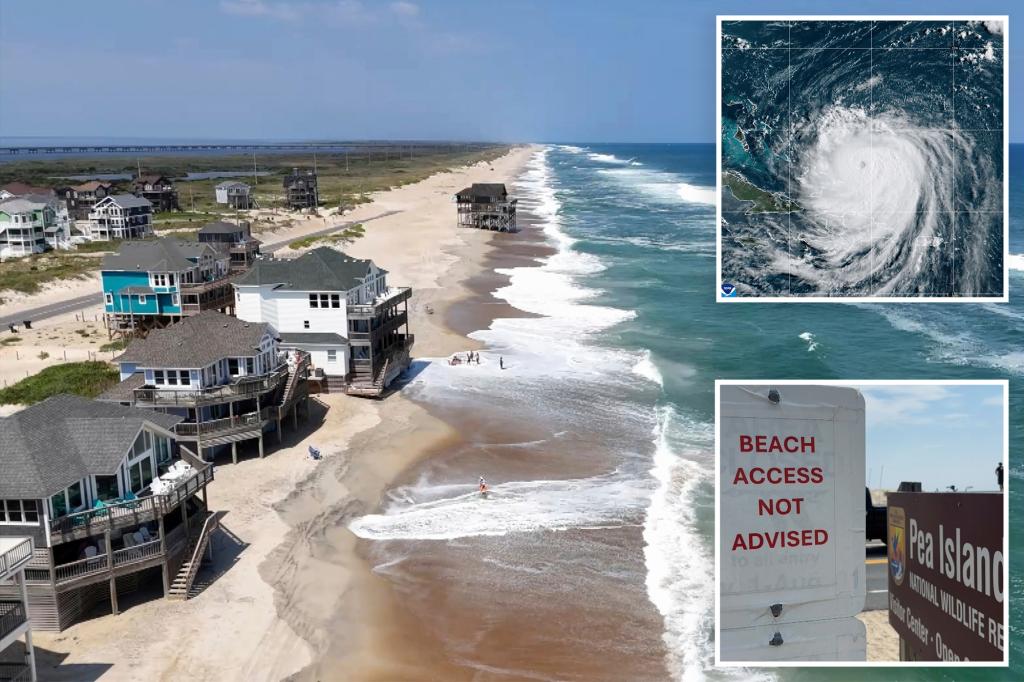
Homes along the Atlantic Coast in Dare County, N.C. ahead of expected impacts from Hurricane Erin. AP
But what it’s lost in steam, it will gain in size, forecasters said.
“While you may be seeing that the hurricane is weakening … the storm is still going to be a very large storm once it gets further north,” Fox Weather Meteorologist Cody Braud told The Post.
“As it moves north it’s going to expand its wind field in size and as that happens you get more energy being dispersed toward the coast in the form of waves,” he said.
“That’s why the intensity is not really the key factor in this story. It’s more about the very large size of Erin, and as it’s moving north it’s growing in size, sending out more waves as the waves are getting bigger and all of these waves are going to go somewhere, and they are going to be slamming into the East Coast,” Braud said.
The brunt of the storm will be felt on North Carolina’s Outer Banks, where a tropical storm warning has been declared and vacationers were ordered to evacuate the barrier islands. A tropical storm warning has also been issued for parts of Virginia.
Hurricane Erin weakened from a Category 4 to Category 2 storm overnight Monday. AP
Tropical storm warnings have not been declared north of Virginia, but officials have warned of rip currents, immense waves, storm surge and flooding as it gets closest to the coast on Wednesday through Friday — about 200 to 300 miles offshore, Braud said.
“Thankfully, there’s no chance the system itself making a direct landfall, but we will kind of get the indirect effects of it as it kind of moves in parallel to the East Coast,” he said.
Waves in off the tri-state area and further north likely won’t reach the 20-25 foot monsters possible off North Carolina but “it all really depends on how close the storm actually gets,” Braud said.
Start your day with all you need to know
Morning Report delivers the latest news, videos, photos and more.
Thanks for signing up!
If the storm remains far enough off the coast, it’s very likely New Yorkers would not even notice any strange weather unless they went down to the beach and saw the raging ocean, he said.
But on the coast, the danger from waves and currents will be so severe that Mayor Eric Adams announced Tuesday that all city beaches will be closed to swimmers Wednesday and Thursday.
Beaches themselves will remain open, but anybody caught trying to swim, surf or do anything else in the waves will be be booted by life guards and park officers.
Several New Jersey beaches were put under similar restrictions, with Gov. Phil Murphy urging residents to stay out of the water.
Mandatory evacuations have been ordered for part of the Outer Banks. AP
New York Gov. Kathy Hochul announced Tuesday afternoon that a High Surf Advisory is in effect Wednesday through Thursday for all Atlantic Ocean beaches in the state and will likely need to be extended.
“As Hurricane Erin passes the East Coast, I am asking all New Yorkers to prepare for the possibility of dangerous conditions along our beaches and coastal cities and towns,” Hochul said in a statement. “New Yorkers are no strangers to hurricanes — that is why I’m urging those living in areas that may be impacted to stay safe and exercise caution until the hurricane tapers off later this week.”
The storm is currently about 650 miles southwest of Bermuda, with maximum sustained winds of 105 miles per hour.
The hurricane force winds extend from the eye up to 80 miles and tropical-storm-force winds extend up to 205 miles from the center.cl
The storm continues to move northwest at a slow pace of just 9 mph, but is expected to turn north and out to sea by the end of the week.