As Erin chugs its way up the Southeastern seaboard, forecasters are eyeing two other tropical disturbances in line behind it in the Atlantic.
For now, neither appears set to pose a threat to the Caribbean or the U.S. anytime soon — if at all.
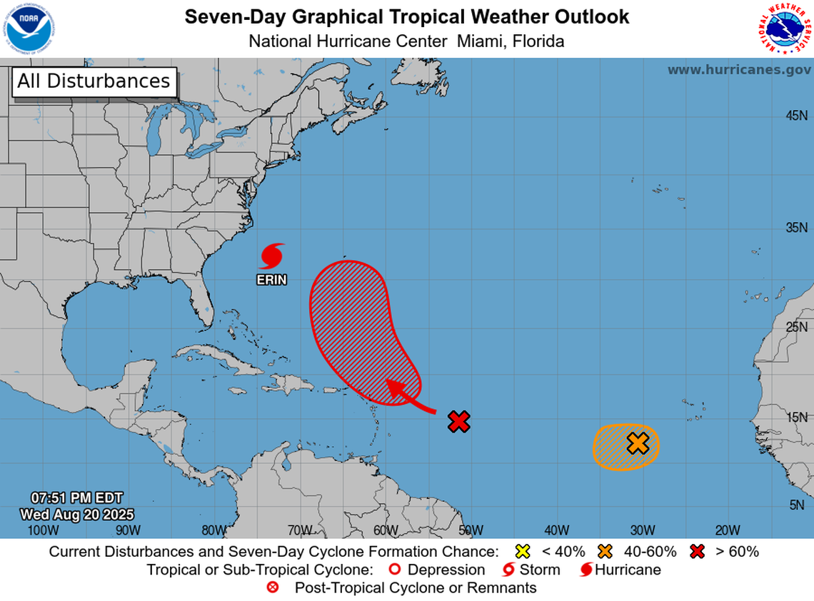
As of the 8 p.m. Wednesday update, the National Hurricane Center gave the closer tropical wave a 70% chance of forming a tropical depression in the next seven days, up from 60% on Monday, and a 10% chance of developing in the next two days.
Forecasters said the disorganized tropical wave is likely to pull together into a tropical depression near or just north of the easternmost Caribbean islands. Long-range computer models suggest this system could follow a similar northern curve out to sea that Erin did, away from occupied land.
Bryan Norcross, hurricane specialist at FOX Weather, said the modeling shows a strong cold front forming over the U.S. in the next few days before pushing out to sea and steering this system away from land. He said it’s very likely the system will make a “hard right” before approaching the Bahamas, although it could bring a bit of rain to the northeastern Carribean islands.
“The concern is low, but with all systems this time of year, we watch to be sure, because if it finds a patch of atmosphere, things do tend to spin up,” he said. “But there’s no sign of a strong system.”
The farther tropical disturbance saw a slight bump in its formation chances on Wednesday, to a 40% chance in the next two to seven days. The hurricane center tagged this one as an “invest” on Tuesday, kicking off heightened scrutiny of the system.
Forecasters said there’s a small pocket of storm-friendly conditions this wave could encounter in the next few days, which could allow a “short-lived tropical depression” time to form — and then potentially dissolve.
“That one has a very short life expectancy,” Norcross said. “If it doesn’t get its act together shortly, it’s going to lose its opportunity to develop into a tropical depression or a tropical storm.”
Some models hint that the system, if it survives the rough conditions, could re-strengthen on the other side of the Caribbean and keep heading west, but Norcross said it seems like a slim chance.
Either way, he said, “It wouldn’t be a threat to Florida in any likely scenario.”
What’s Hurricane Erin doing?
Hurricane Erin, a Category 2, continued its northern path along the Southeastern coast on Wednesday.
Florida’s worst impacts — deadly rip currents, rough boat conditions and high waves that surfers are excited about — are in effect through at least Friday. Erin’s massive wind field means that rough surf is expected from Palm Beach all the way to the Northeast for the next few days.
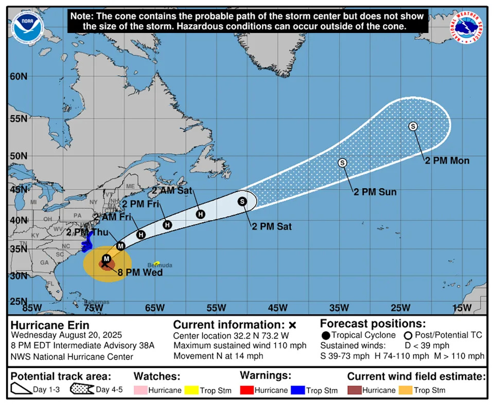
Hurricane Erin, a Category 2, has a massive wind field that will send tropical-storm-force winds over the coast of North Carolina and Virginia on Thursday.
Most of North Carolina’s coast remained under a tropical storm warning and some portions were under a storm surge warning, as Hurricane Erin is expected to slosh the state’s barrier islands with up to 4 feet of water. The Outer Banks were evacuated in advance of the storm.
Parts of Virginia’s coast were upgraded to a tropical storm warning as well. Bermuda remained under a tropical storm watch.
The hurricane center said Erin is expected to run out of warm water soon and begin to slowly lose strength as it curves north into the frigid waters near Nova Scotia. By Monday, it should be down to a tropical storm once again.
Miami Herald staff writer Devoun Cetoute contributed to this report.