After a spectacular Saturday, our very noticeable temperature-changing front will be on our doorsteps Sunday.
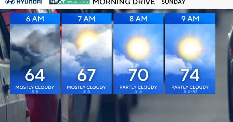
Expect mixed skies, light winds and just a slight chance of an afternoon or evening shower. Highs will once again be in the low to mid-80s.

CBS News Philadelphia.
The week starts with a chance of showers and storms early Monday morning, but much of the day will be a mix of sun and clouds.
The cold front finally crosses the area Monday night and ushers in cooler and drier air with highs in the 70s for the remainder of the week. Monday night could bring a slight chance of a shower or storm. Severe weather is NOT expected.
Hard to believe Labor Day weekend is next Saturday and Sunday. Labor Day itself is a week from Monday on Sept. 1, which is the actual start of meteorological fall. WOW! Summer really flew by.
Current forecast trends keep us dry for the holiday weekend, but there will be several disturbances in the regions, so check back regularly as the NEXT Weather Team fine-tunes the forecast.
Fernand: Watching the new tropical storm, South-Southeast of Bermuda, moving north around 20 mph. Current status gives it 40 mph winds, making it a low-end tropical storm. Watching, but not expecting it to threaten land.

CBS News Philadelphia.
Here’s your 7-day forecast:

CBS News Philadelphia.
Sunday: A.m. sun, p.m. clouds. High 84, Low 64.
Monday: Isolated storm? High 85, Low 68.
Tuesday: Mostly sunny. High 80, Low 61.
Wednesday: Mostly sunny. High 77, Low 60.
Thursday: Partly cloudy. High 79, Low 56.
Friday: Gorgeous. High 80, Low 60.
Saturday: A few showers possibly. High 80, Low 59.
More from CBS News