HOUSTON – Monday marks eight years since Hurricane Harvey made landfall along the Middle Texas Coast near Port Aransas, unleashing devastating winds to parts of the state and catastrophic flooding to other parts, including the Houston area.
Summary of Harvey
Harvey’s birth began on Sunday, Aug. 13, 2017, as a tropical wave which emerged off the coast of Africa.
The wave would eventually merge with a broad area of low pressure near the Cabo Verde Islands
The wave would remain disorganized for several days before strengthening and officially becoming Tropical Storm Harvey on Thursday, Aug. 17.
Harvey impacted the Windward Islands on Friday, Aug. 18. It would weaken back to a tropical wave late Saturday evening. Although there was potential for Harvey’s remnants to reorganize and strengthen, a tropical cyclone had failed to form as the remnants moved into the Yucatan Peninsula on Tuesday, Aug. 22.
It would not be until the next day, Wednesday, Aug. 23, that the remnants would reform into Tropical Depression Harvey out over the warm waters of the Gulf and the Bay of Campeche.
The National Hurricane Center said it was initially believed Harvey would make landfall along the Texas Coast as a category 1 hurricane. However, weakening wind shear over the waters of the Gulf led to Harvey strengthening rapidly.
Hurricane Harvey satellite and radar image (National Weather Service)
Harvey would undergo rapid intensification 48 hours before making landfall near Port Aransas on San Jose Island around 10 p.m. on Aug. 25, 2017, as a devastating category 4 hurricane. Harvey had maximum sustained winds of 130 mph at landfall and reemerged over the bay to make landfall again near the communities of Rockport and Fulton, causing widespread destruction.
Satellite image of Hurricane Harvey just prior to landfall on Aug. 25, 2017. (National Weather Service)
Harvey would slow down to a forward motion of around 5 mph before meandering for several days across parts of Southeast Texas. It would eventually reenter the Gulf, maintaining tropical storm strength the entire time before making a final landfall near Cameron, LA on Aug. 30.
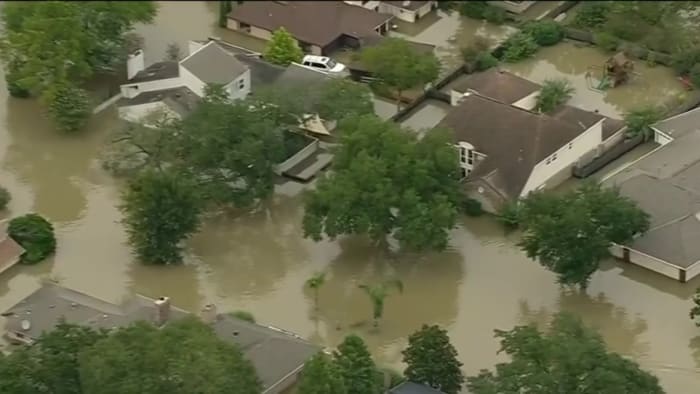
Flooding from Harvey. Image from click2houston.comRainfall impact
Extremely heavy rainfall would cause unprecedented flooding across much of Southeast Texas. Some areas saw over 50 inches of rain over the course of a few days from Harvey. National Weather Service records show Friendswood saw 56 inches of rain from Aug. 25 to Aug. 31, 2017 as a result of Harvey.
Flooding in Houston from Hurricane Harvey (2017) (National Weather Service)
Rivers, creeks and bayous across Southeast Texas surged, many of them cresting at record levels.
Preliminary crests (National Weather Service)
The image above shows the preliminary crests of many major waterways across the Houston area. Of these flood points monitored by the National Weather Service, 46 out of the 67 reached major flood stage with 31 of those setting records.
Floodwaters in Galveston Bay from space (NASA)
Harvey dumped so much water over the area that the impact could be seen from space. In the image above, the impact of sediment-filled floodwaters can be seen as the entire Galveston Bay system turned brown and a trail of the floodwaters can be seen going out the Galveston Channel into the Gulf.
Cost of Harvey
Harvey would end up becoming the second costliest hurricane to hit the U.S. mainland since 1900, surpassed only by Hurricane Katrina.
The Texas Division of Emergency Management estimates Harvey caused around $125 billion in damage.
At the time, it was the first hurricane to hit the Texas coast since Hurricane Ike in 2008 and the first major hurricane since Bret in 1999.
Estimated 5 day rainfall totals in SE Texas from Harvey (National Weather Service)
Tens of thousands of people were displaced by the storm and thousands of homes and businesses were destroyed. The National Weather Service said at least 70 deaths were blamed on the storm.
The National Weather Service has an extensive archive of information related to Hurricane Harvey. Click here for more.
Copyright 2024 by KPRC Click2Houston – All rights reserved.