Tracking Labor Day weekend rain for the Gulf Coast
GET AWAY KIT BACKING UP GOING FORWARD THINKING IT WAS LIKE A FISHHOOK. ULTIMATELY THEY TOOK OFF AND RIPPED OFF THE ENTIRE BACK INTO THE CAR. FOR A FOR PERSON WHO OWNS THAT CAR RENTAL HAS SO YEAH, IT’S IT’S A EN ROUTE PICKET. WE’RE GONNA WHEN WE KNOW WHAT WE’RE ALL RIGHT. WITH THE HOLIDAY WEEKEND, A LITTLE BIT OF RAIN. SO IT’S NOT GOING TO RAIN THE ENTIRE WEEKEND. WE HAVE SOME VERY NICE DAYS AHEAD OF US, BUT IT’S A LITTLE UNSETTLED WHERE THE MODELS MIGHT BE UNDER DOING SO MUCH RAIN. HOW MUCH RAIN WE COULD HAVE ON SUNDAY. SO JUST WANT TO GET YOU PREPARED FOR THAT. >> ON MONDAY, THAT WILL BE OUR HIGHEST RAIN CHANCE OF THE NEXT 3 DAYS. BUT BY MONDAY, HOPEFULLY YOU’RE KIND WRAPPING UP SOME OF YOUR HOLIDAY PLANS RIGHT NOW. WE’RE DRY. HAVE A NICE EVENING FOR US ON FRIDAY NIGHT. FRIDAY NIGHT FOOTBALL WAS GOOD AS WE HEAD INTO TOMORROW. TOMORROW IS GOING TO LOOK A LOT LIKE TODAY, MAINLY INLAND THUNDERSTORMS COULD HAVE A FEW PASSING BY SOME OF THE COASTAL SPOTS, BUT BULK OF THE ACTIVITIES INLAND. THEN ON SUNDAY AND MONDAY, THIS STATIONARY BOUNDARY IS GOING TO THROW IT ALL FOR A LOOP. IT’S GONNA COME LINGER AND MEANDER AROUND FLORIDA. AND AS IT DOES SO MORE TROPICAL MOISTURE TO SOME COME RUSHING ON IN COUPLE THAT WITH SOME ONSHORE WINDS AND WE ARE GOING TO HAVE AN UNSETTLED PATTERN FOR SUNDAY AND INTO MONDAY. SO LET’S WALK THROUGH THE FUTURECAST ON SATURDAY. I THINK IT DOES A PRETTY GOOD JOB INDICATING WHAT’S GOING TO OCCUR. IT LOOKS LIKE TODAY ISOLATED SHOWERS TO BEGIN. IT DOES GET PRETTY SCATTERED FOR THE AFTERNOON, BUT MOST OF IT IS INLAND OR ON THE OTHER SIDE OF THE STATE. IF YOU’RE GOING TO THE OTHER SIDE OF THE STATE THIS WEEKEND, THERE’S GOING TO SEE A LOT OF RAIN. SO JUST BE PREPARED FOR THAT. NOT AS MUCH FOR SUNDAY. WHAT HAPPENS ON SUNDAY AS WE HAVE NOW ONSHORE WINDS. WE NOW HAVE A LOT MORE TROPICAL MOISTURE. SO REMEMBER, WHEN WE TALK ABOUT ONSHORE WINDS, I CAN GIVE US A LOT OF MORNING SHOWERS. THAT’S WHY I THINK THIS IS KIND OF UNDER DOING WHAT WE COULD HAVE ON SUNDAY. SO JUST KIND OF KEEP THAT IN THE BACK OF YOUR MIND. I HOPE IT DOESN’T RAIN THAT MUCH. WE DON’T NEED ANY RAIN. BUT KEEP IN MIND ON SUNDAY, THERE’S A HIGHER CHANCE OF SOME OF THOSE MORNING SHOWERS AND EARLY AFTERNOON BEFORE THEY HEAD ON INLAND. THERE IS A LOT OF RAIN TO TRACK FOR THE AFTERNOON ON SUNDAY, MAINLY EAST OF 75. BUT NOT ALL OF IT COULD BE NEAR SOME PARTS OF THE CALOOSAHATCHEE. IF YOU’RE GOING TO BE THERE. BUT COASTAL SPOTS SHOULD BE A LITTLE BIT DRIER FOR THE AFTERNOON. THIS IS SUNDAY, 7 O’CLOCK. WE STILL HAVE SOME BIG DOWNPOURS FOR AREAS INLAND. THEN ON MONDAY, THAT WILL BE OUR HIGHEST RAIN CHANCE. SO OVER THE NEXT 3 DAYS, IT LOOKS LIKE THIS. THIS IS KIND OF GENERALLY SPEAKING WHERE YOU HAVE THE HIGHER AMOUNTS INLAND BECAUSE WE’RE REPEATEDLY SEE THE HIGHEST AMOUNT OF RAIN BUT COASTAL SPOTS, YOU’LL STILL GET A PASSING SHOWER OR 2. SO JUST STAY WITH GULF COAST NEWS WILL KIND OF BE NAVIGATING THAT TRICKY FORECAST FOR YOU EACH MORNING AND EACH EVENING RIGHT HERE WE ARE IN THE TROPICS. ANOTHER AREA OF INTEREST, 30% CHANCE OVER THE NEXT 2 TO 7 DAYS. THE TROPICAL WAVE IS STILL COMING OFF THE WEST COAST OF AFRICA. SO CAN’T FORGET IS OVER LAND. SO BY MONDAY AND INTO NEXT WEEK, THAT’S WHEN WE’LL BE WATCHING THIS. I GOT TO SAY WE’RE NOT IMPRESSED WITH THIS SYSTEM. LOOKING AT A LOT OF THE MODELS HAS MAYBE A TROPICAL DEPRESSION, TROPICAL STORM AT BEST NEXT NAMES. GABRIEL. BUT IT KIND OF JUST FADES AWAY HERE OR LIFTS OFF TO THE NORTH AGAIN, NOT GOING TO BE TOO CONCERNED AT THIS POINT WITH A BIG HURRICANE OR A BIG STORM HEADED IN OUR DIRECTION WHATSOEVER. SO AGAIN, ANOTHER WEEK, I THINK WE’RE IN THE CLEAR TEMPERATURES TOMORROW MORNING MID TO UPPER 70’S. IT’S GOING TO BE A NICE SUNNY START TO THE DAY BY THE AFTERNOON. WE’RE AT 92. WE WILL HAVE SCATTERED STORMS SATURDAY. MORE SO INTO SUNDAY INTO MONDAY, LABOR DAY ITSELF, UPPER 80’S FOR MONDAY AND TUESDAY BECAUSE OF THE INCREASE OF CLOUD COVER AND THE RAIN OPPORTUNITIE
Rain chances are expected to increase as we head into Labor Day weekend. An approaching front is responsible for the setup over the next few days. Where that front will stall out exactly is still uncertain, and that determines where the highest coverage will be. Saturday and Sunday’s rain chances are lower than Monday’s, where increased coverage of showers and thunderstorms will start the week off. The rain will help drop our high temperatures closer to the average of 91 degrees for this time of year. Monday and Tuesday, we will see highs in the upper 80s, thanks to the rain. Tracking the TropicsIn the tropics, there is still the area off the coast of Africa to watch, and it’s at a 30% chance of development for now as we wait for the tropical wave to move offshore and into the Atlantic. Read more.The Atlantic hurricane season runs from June 1 through Nov. 30. Follow Gulf Coast News online and on-air for Southwest Florida’s Most Accurate weather forecast.Be prepared with the Gulf Coast News 2025 Hurricane GuideLive Interactive RadarCheck out the interactive Gulf Coast Live RadarWatch your Gulf Coast Weather forecasts on TV or onlineHere’s where to find our latest weather forecast videoYou can also watch newscasts live or on-demand hereOr download the Gulf Coast News app to stream on your phone or tabletFollow the Gulf Coast Storm Team on social mediaChief Meteorologist Allyson Rae on Facebook and XMeteorologist Caroline Castora on Facebook and XMeteorologist Jim Dickey on Facebook and XMeteorologist Jason Dunning on Facebook and XMeteorologist Rob Duns on Facebook and XMeteorologist Lauren Hope on Facebook and XMeteorologist Raphael Tavernier on Facebook and XDOWNLOAD the free Gulf Coast News app for your latest breaking news and weather alerts. And check out the Very Local Gulf Coast app to stream news, entertainment and original programming on your TV.
FORT MYERS, Fla. —
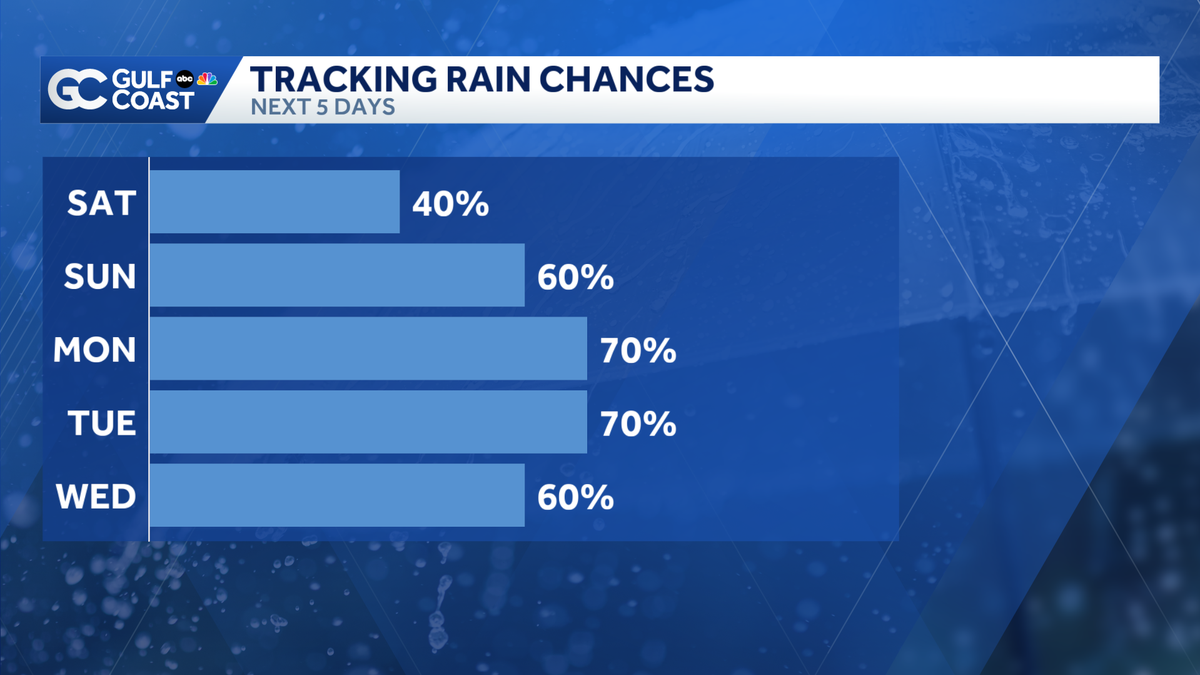
Rain chances are expected to increase as we head into Labor Day weekend. An approaching front is responsible for the setup over the next few days. Where that front will stall out exactly is still uncertain, and that determines where the highest coverage will be.
Saturday and Sunday’s rain chances are lower than Monday’s, where increased coverage of showers and thunderstorms will start the week off.
The rain will help drop our high temperatures closer to the average of 91 degrees for this time of year. Monday and Tuesday, we will see highs in the upper 80s, thanks to the rain.
Tracking the Tropics
In the tropics, there is still the area off the coast of Africa to watch, and it’s at a 30% chance of development for now as we wait for the tropical wave to move offshore and into the Atlantic. Read more.
The Atlantic hurricane season runs from June 1 through Nov. 30. Follow Gulf Coast News online and on-air for Southwest Florida’s Most Accurate weather forecast.
Live Interactive Radar
Watch your Gulf Coast Weather forecasts on TV or online
Follow the Gulf Coast Storm Team on social media
- Chief Meteorologist Allyson Rae on Facebook and X
- Meteorologist Caroline Castora on Facebook and X
- Meteorologist Jim Dickey on Facebook and X
- Meteorologist Jason Dunning on Facebook and X
- Meteorologist Rob Duns on Facebook and X
- Meteorologist Lauren Hope on Facebook and X
- Meteorologist Raphael Tavernier on Facebook and X
DOWNLOAD the free Gulf Coast News app for your latest breaking news and weather alerts. And check out the Very Local Gulf Coast app to stream news, entertainment and original programming on your TV.