JACKSONVILLE, Fla. – Jacksonville and neighboring communities are waking up to near-perfect weather conditions.
Breezes are down and the sunshine is out for most of the area.
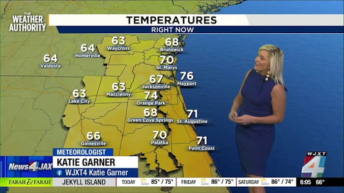
Early temperatures around sunrise hovered in the upper 60s to 70s—Jacksonville was sitting at 67 degrees with areas along the coastline in the low 70s.
There’s no breeze out there, making for a comfortably mild start.
As the sun rises higher, temperatures are forecast to climb into the mid-80s along the beaches and up to the low 90s inland in spots like Keystone Heights, Middleburg, and Macclenny.
Coastal flood advisory
While sunshine takes center stage, there is a coastal flood advisory in effect for parts of the First Coast.
Most neighborhoods are expected to experience brilliant sunrises and only a little cloud cover, with a few quick-moving showers off the Atlantic possible.
If you snap a perfect sunrise or spot weather impact from the tides, share your photos with the community on SnapJAX.
Weekend warmth and next week’s changes
As the week unfolds, Jacksonville’s daytime highs are expected to run a little above average.
The Exact Track 4D forecast shows highs in the 91 to 92 degree range from Friday through Sunday, before cooling off to the upper 80s early next week.
Our daytime highs are seasonally right where we should be, but as we get into the weekend, we’re going to be a little above average.
Next week, as chances for rain increase, those temperatures are forecast to dip back below average into the 80s.
Any rain today looks to be confined to brief pop-up showers, mostly well south of Jacksonville, with spots like Palatka facing a 20 percent chance.
Copyright 2025 by WJXT News4JAX – All rights reserved.