
San Antonians aren’t strangers to flash floods. After all, the city sits in what’s called the “Flash Flood Alley.” But this year, two fast-moving late night storms have claimed more lives than the “Great Flood” of 1998, which left 11 dead.
The death toll this year has already reached 15, which raises urgent questions about why these flash flooding events appear to be even deadlier now.
Eleven people were killed along Beitel Creek, one person was killed several miles upstream and another one near Leon Creek and Highway 90 — 13 deaths, all in the early morning of June 12, making it the deadliest single-day flood event in San Antonio history.
Another two people were found dead last weekend after a quick-moving storm flooded Salado Creek.
Unlike the disaster in 1998, this year’s floods were narrower in scope but more lethal inside the city — a shift experts say reflects changing weather patterns, vulnerable terrain and the limits of infrastructure designed to keep people safe.
On June 12, storms stalled over San Antonio’s Northeast Side, dumping more than seven inches of rain in three hours across the Beitel Creek watershed.
At San Antonio International Airport, the National Weather Service gauges recorded 6.11 inches for the day, including a record-setting 3.9 inches in a single hour between 3 a.m. and 4 a.m.
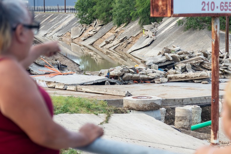
Following the tragedy, the San Antonio River Authority conducted a post-flood technical assessment that found the creek rose by as much as a foot every 10 minutes.
That rapid surge turned the Loop 410 frontage road into a deadly trap. At least 15 vehicles were swept away as water overtopped the roadway.
The River Authority’s assessment highlighted several vulnerabilities. The stretch of Loop 410 frontage road where most of the deaths occurred ran directly alongside the creek and lacked a high-water detection system to warn drivers, unlike nearby water crossings.
 Bystanders look at debris on Vicar Drive in the wake of severe flooding at Beitel Creek on June 12, 2025. Credit: Blaine Young for the San Antonio Report
Concrete channel walls in the same area collapsed under the force of the water and debris. The report called this section “the most unexpected and tragic impact of the storm event” and recommended that roads like these be evaluated for flood risk and considered for future mitigation projects — while acknowledging that Bexar County already faces a backlog of flood control needs.
These findings underscored how quickly San Antonio’s creeks can overwhelm roads and infrastructure. But the June 12 flood didn’t just raise questions about engineering gaps — but also the type and intensity of storms hitting the region.
National Weather Service meteorologist Mack Morris pointed to San Antonio’s location in the “Flash Flood Alley” as a factor that makes it especially vulnerable to intense bursts of rainfall.
“If you’re living in this area, you just have to understand that water will rise rather quickly. The soil here is very shallow, and underneath it the bedrock is limestone, which doesn’t absorb any rain,” Morris said. “The creek beds are very flashy, which means they quickly fill up if there’s any rain, particularly with heavier rainfall rates like we saw in Kerr County. It does not take much to see a response in some of those creek beds and it’s the same thing in San Antonio and Bexar County.”
Over the July Fourth weekend, 117 people were killed in nearby Kerr County because of catastrophic flash flooding, with the statewide total of flood deaths reaching 135.
Those conditions, combined with record-setting rainfall, proved deadly in June and again in late August over Labor Day weekend, when another heavy storm flooded Salado Creek and two more people were found dead the next morning.
At the airport, weather gauges recorded 3.1 inches of rain from last weekend’s storm, bringing the summer total to just over 12 inches, San Antonio’s 19th wettest summer on record. In 2024, the NWS recorded 7.33 inches of rain for the summer, close to the 20-year average of 7.84 inches.
But Morris noted that 75% of this season’s rainfall fell on only two days: June 12 and Aug. 31.
“With a warming planet, more extreme events are going to become more likely,” Morris said. “There’s more moisture loading in the atmosphere when temperatures are warmer. That shifts the possibility of seeing more extreme rainfall events further to the right, so flash floods are more likely.”
The River Authority’s findings and record rainfall totals explain how the floods unfolded, but Morris said another factor lies in how people respond when warnings are issued.
“We issue warnings and we do our best to protect the public, but it’s up to the public and other folks to heed the warning and take action,” Morris said. “The number one thing you can do if you’re in a vehicle and you encounter floodwaters is to find a different way, or turn around. We like to stress ‘Turn Around, Don’t Drown.’”
Alongside record rainfall, the timing of both storms made them even more dangerous. They struck in the early morning and late night hours, when drivers were less likely to see high water until it was too late. Eleven of the victims were in vehicles — a pattern Morris said is consistent with national flash flood fatality data.
Those losses illustrate how deadly flash flooding remains in San Antonio, even after decades of flood-control projects. With the fall storm season still ahead, state lawmakers may be able to provide some relief.
Senate Bill 5, passed during the Texas Legislature’s special session, is now awaiting the governor’s signature. The bill would allocate $50 million from the state’s Economic Stabilization Fund to install flood warning sirens, expand weather gauge networks and purchase other safety equipment across the state.
The two-year fund would be available to several affected local governments, including in Bexar County, with aims of preventing future tragedies. San Antonio has already endured its deadliest flood year in more than two decades.