Multiple severe thunderstorm warnings are issued for parts of central and western Massachusetts Saturday as strong cells move east across the state. The National Weather Service issued: Severe thunderstorm warning for northwestern Worcester County and northwestern Middlesex County until 3:45 p.m. Severe thunderstorm warning for Worcester County, east central Hampshire County, southeastern Franklin County and southeastern Hampden County until 4:30 p.m. WATCH: Live Interactive RadarA severe thunderstorm watch remains posted for Essex, Middlesex, Norfolk, Suffolk, Worcester, Franklin, Hampden, Hampshire and Berkshire counties until 8 p.m.”This means that conditions are favorable for the development of severe thunderstorms and some isolated tornadoes, possibly, but more so straight line winds, very heavy rain, dangerous lightning,” StormTeam 5 meteorologist A.J. Burnett said. Multiple tornado warnings were posted and expired for parts of Franklin, Hampshire, Hampden and Berkshire counties as the storms marched east.Saturday started off hazy and humid, but storms began to form west of Massachusetts after 1 p.m. StormTeam 5 has labeled Saturday an Alert Day.StormTeam 5 tools: Alerts | Radar | Map RoomThe severe weather risk is greatest northwest of Boston. The biggest concern with these storms is damaging wind gusts, flooding downpours and large hail. There is also a low tornado risk.The risk of storms in eastern Massachusetts starts after 5 p.m. and continues through 10 p.m. Overnight, lingering spot showers will be possible with areas of fog.Sunday will be a cooler, less humid and wet day, with the steadiest showers expected through the early afternoon. It will remain damp and cool throughout Sunday evening with a few showers lingering over Cape Cod and the Islands through early Monday morning. Tornado Safety: The NWS warns residents that flying debris can be dangerous to those caught without shelter, and mobile homes could be damaged or destroyed. Damage to roofs, windows and vehicles could occur, and tree damage is likely.STAY INFORMED: Follow StormTeam 5 on FacebookResidents in the storms’ path are advised to go to a basement or an interior room on the lowest floor of a sturdy building and avoid windows. If you are outdoors, in a mobile home or vehicle, move to the closest substantial shelter and protect yourself from flying debris.If you are in a vehicle, you are not safe, the NWS warns. The best course of action is to drive to the closest shelter. If you are unable to make it to a safe shelter, either get down in your car and cover your head, or abandon your car and seek shelter in a low lying area such as a ditch or ravine.
BOSTON —
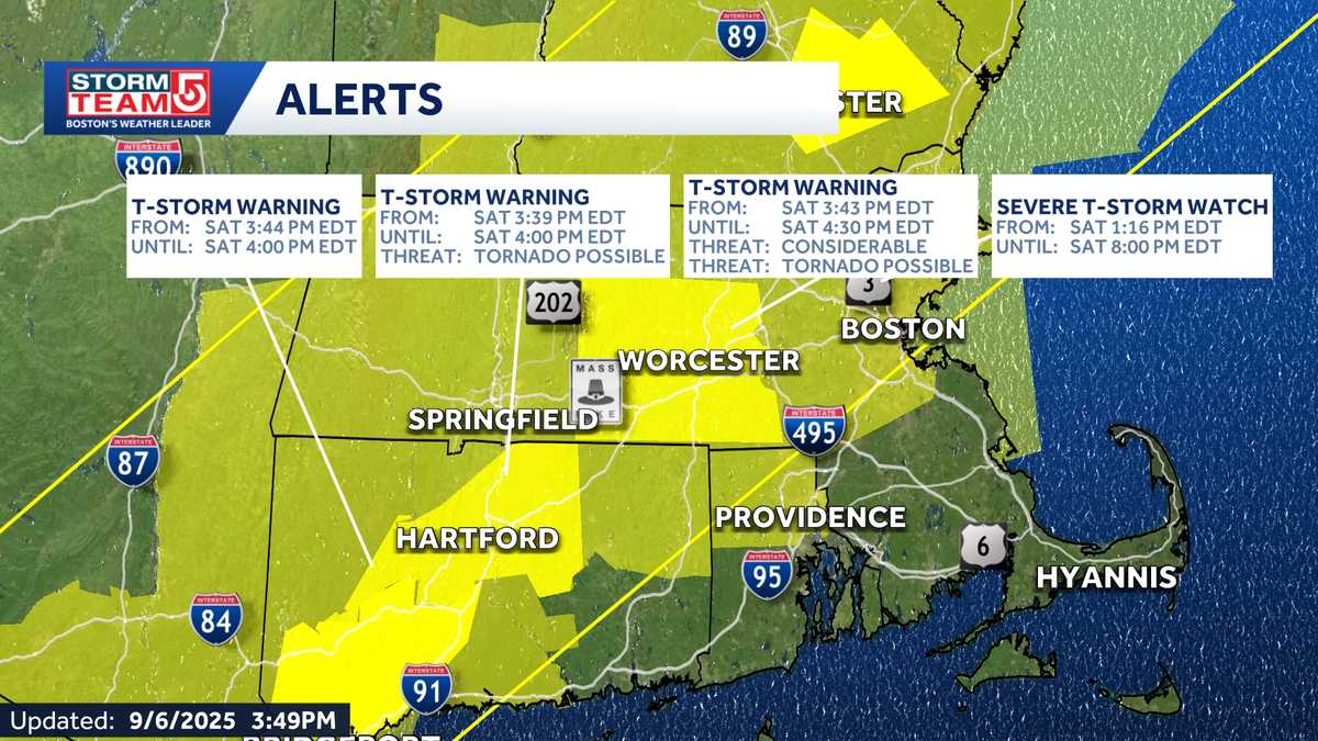
Multiple severe thunderstorm warnings are issued for parts of central and western Massachusetts Saturday as strong cells move east across the state.
The National Weather Service issued:
- Severe thunderstorm warning for northwestern Worcester County and northwestern Middlesex County until 3:45 p.m.
- Severe thunderstorm warning for southwestern Worcester County, southeastern Hampshire County, southeastern Franklin County and eastern Hampden County until 3:45 p.m.
- Severe thunderstorm warning for parts of southwestern Hampden County until 3:30 p.m.
- Severe thunderstorm warning for northwestern Worcester County and northeastern Franklin County until 3:30 p.m.
- Severe thunderstorm warning for Southwick and Westfield in Hampden County until 3:30 p.m.
A severe thunderstorm watch remains posted for Essex, Middlesex, Norfolk, Suffolk, Worcester, Franklin, Hampden, Hampshire and Berkshire counties until 8 p.m.
“This means that conditions are favorable for the development of severe thunderstorms and some isolated tornadoes, possibly, but more so straight line winds, very heavy rain, dangerous lightning,” StormTeam 5 meteorologist A.J. Burnett said.
Multiple tornado warnings were posted and expired for parts of Franklin, Hampshire, Hampden and Berkshire counties as the storms continued to march east.
Saturday started off hazy and humid, but storms began to form west of Massachusetts after 1 p.m. StormTeam 5 has labeled Saturday an Alert Day.
StormTeam 5 tools: Alerts | Radar | Map Room
A severe thunderstorm watch is posted for Essex, Middlesex, Norfolk, Suffolk, Worcester, Franklin, Hampden, Hampshire and Berkshire counties until 8 p.m.
“This means that conditions are favorable for the development of severe thunderstorms and some isolated tornadoes, possibly, but more so straight line winds, very heavy rain, dangerous lightning,” StormTeam 5 meteorologist A.J. Burnett said.
The severe weather risk is greatest northwest of Boston. The biggest concern with these storms is damaging wind gusts, flooding downpours and large hail. There is also a low tornado risk.
A line of strong to severe storms will form Saturday afternoon in western Massachusetts and move into eastern Massachusetts, gradually losing strength.
The risk of storms will arrive after 5 p.m. in eastern Massachusetts and continue through 10 p.m. Overnight, lingering spot showers will be possible with areas of fog.
Sunday will be a cooler, less humid and wet day, with the steadiest showers expected through the early afternoon. It will remain damp and cool throughout Sunday evening with a few showers lingering over Cape Cod and the Islands through early Monday morning.
Tornado Safety:
The NWS warns residents that flying debris can be dangerous to those caught without shelter, and mobile homes could be damaged or destroyed. Damage to roofs, windows and vehicles could occur, and tree damage is likely.
STAY INFORMED: Follow StormTeam 5 on Facebook
Residents in the storms’ path are advised to go to a basement or an interior room on the lowest floor of a sturdy building and avoid windows. If you are outdoors, in a mobile home or vehicle, move to the closest substantial shelter and protect yourself from flying debris.
If you are in a vehicle, you are not safe, the NWS warns. The best course of action is to drive to the closest shelter. If you are unable to make it to a safe shelter, either get down in your car and cover your head, or abandon your car and seek shelter in a low lying area such as a ditch or ravine.
