A weak cold front drifts through the Philadelphia area tonight with only a few sprinkles in a few spots, otherwise dry. Skies stay partly cloudy north, with more clouds pushing into southern New Jersey and Delaware by morning. Lows settle into the 50s to low 60s with some patchy fog possible. It will feel a bit muggy for mid-September.

CBS News Philadelphia
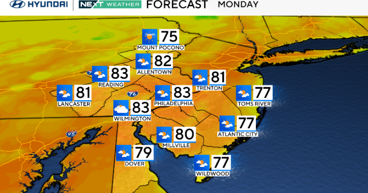
On Monday, clouds increase from south to north as a coastal low begins to develop off the Carolinas. Most areas remain dry during the day, but onshore flow keeps highs cooler near the coast, mainly 70s there, while inland spots are set to reach the upper 70s to low 80s. Humidity levels climb slightly, making it feel more summerlike again.
Unsettled weather takes over Monday night through Wednesday as the offshore low drifts north. Clouds and periods of showers will affect the region, especially across southern Delaware and southern New Jersey, where rainfall could be heavier. Winds will also increase along the coast with gusts near 30 mph Tuesday into Wednesday. By late Thursday, the system moves away, leading into a drier, cooler stretch for the end of the week and the weekend.
This weekend is the last weekend of the summer. Fall officially begins at 2:19 p.m. on Sept. 22.
Here’s your 7-day forecast:

CBS News Philadelphia
Monday: Increasing clouds. High 83, Low 62.
Tuesday: A late shower? High 76, Low 63.
Wednesday: Scattered showers. High 72, Low 64.
Thursday: Morning showers. High 81, Low 65.
Friday: Sunny skies. High 87, Low 63.
Saturday: Mostly sunny. High 80, Low 62.
Sunday: Partly cloudy. High 77, Low 60.
More from CBS News