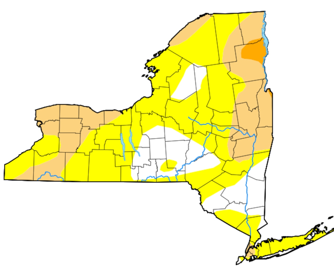
Syracuse, N.Y. — More than 80% of New York state is now considered either abnormally dry or already in a drought, according to today’s U.S. Drought Monitor report.
And it’s only going to get drier.
“For the next 14, probably 20 days, we get one good rainfall and the rest is all dry,” Mark Wysocki, New York state climatologist, said Wednesday.
The next couple of weeks will also likely be warmer than normal, which will further dry out parched soil and wilt plants.
Rain is likely at the end of next week, Wysocki said. Even that won’t be enough to make up the rain deficit that has built up this summer. Syracuse, for example, is about 3.5 inches below normal for the summer, equivalent to an entire month’s worth of rain.
In Rochester, the period since July 1 has been the fourth-driest on record. For Buffalo, the sixth-driest; in Syracuse, the 15th-driest.
The dry conditions have prompted the state Department of Environmental Conservation to call for residents to voluntarily conserve water, especially those on wells. Some streams in Upstate New York are at record low levels. On a popular section of the Salmon River, which is lower and warmer than normal for this time of year, the DEC has postponed the start of fly-fishing season from Sept. 15 to at least Oct. 31.
The main reason for the lack of rain is that the jet stream, a ribbon of air high in the atmosphere, has streamed north of the U.S.-Canadian border all summer, Wysocki said. That means storms have stayed in Canada, with little moisture making its way to the U.S.
In place of rain, high-pressure systems have dominated much of the Northeast this summer, said Bob Van Dillen, a meteorologist with Fox Weather.
“You’ve had these high-pressure systems coming in nonstop, one after another, and they’ve just been reloading over the same area,” Van Dillen said.
Two-thirds of the contiguous U.S. is either abnormally dry or in a drought. Parts of the West are at extreme or exceptional drought levels, the two worst.
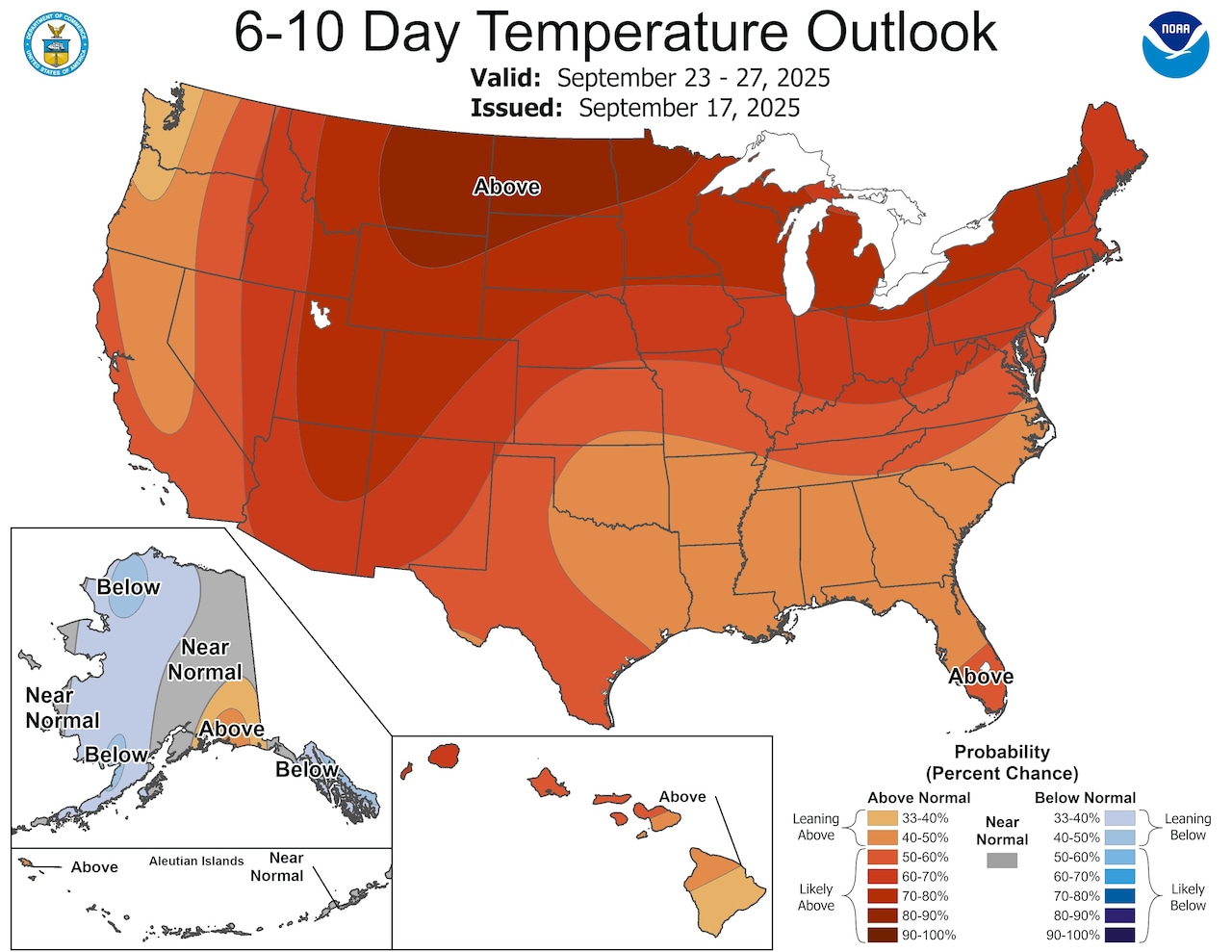 There’s a greater than 70% chance that next week will be warmer than usual across Upstate New York. The entire contiguous U.S. will likely be warmer than normal.Climate Prediction Center
Also missing this summer are hurricanes. There’s been just one hurricane this season, which runs from June to November. The lack of hurricanes is also the result of a high-pressure system, this time sitting over the Atlantic Ocean.
There might be relief in sight for the parched Northeast, experts say. First, it looks like hurricane season, which normally peaks in September, might finally kick into gear in October and November, Van Dillen said.
Whether any moisture from hurricanes will depend on whether the high pressure starts to crumble, Wysocki said.
The other promising precipitation source on the horizon is the development of a La Nina weather pattern in the equatorial waters of the eastern Pacific Ocean. A La Nina is likely to bring a wetter fall, Van Dillen said.
“You’ve got better chances of rain coming from October, November through December,“ Van Dillen said. ”It’s going to be a weak La Nina, but it’s still going to open up the chances for better rainfall coming in and cooler temperatures.”
If you purchase a product or register for an account through a link on our site, we may receive compensation. By using this site, you consent to our User Agreement and agree that your clicks, interactions, and personal information may be collected, recorded, and/or stored by us and social media and other third-party partners in accordance with our Privacy Policy.