The first day of fall in Southeast Texas is feeling less like sweater weather and more like a classic Houston September.
SE Texas should expect rain and isolated thunderstorm chances mainly south of I-10 starting in the morning, with another round possible in the afternoon.
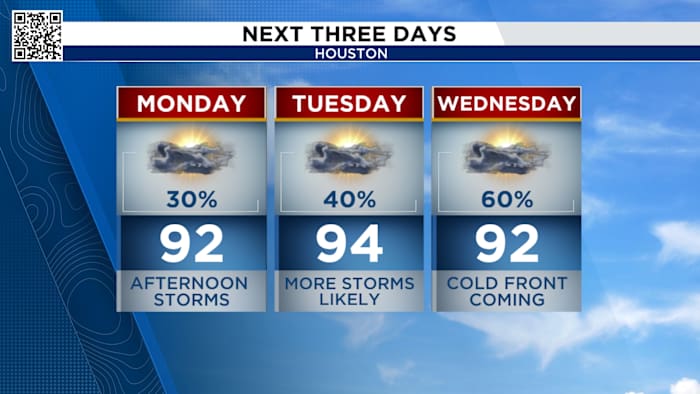
Monday’s Forecast
Temperatures are expected to reach the upper 80s and 90s through the start of the week, with humidity remaining high and rain chances climbing. While some showers and maybe a thunderstorm are likely on Monday—mainly along the coast in places like Lake Jackson and Freeport—areas without rain may still see highs near 90 degrees.
Morning showers and storms mainly near the coast
Thunderstorms are most likely to fire up south of Interstate 10 as the day progresses. By evening, most of those showers are forecast to taper off.
At 1:19 p.m. on Monday, it will be the official start of fall, when the direct rays of the sun are over the equator.
hit and miss showers and storms mainly south of I-10
To learn more about the autumnal equinox, click here. You’ll also find out why it takes much longer to get cooler temperatures in Houston.
The start of fall (Copyright 2025 by KPRC Click2Houston – All rights reserved.)
Although it is the first day of Fall, temperatures warm to the 90s. Temperatures will range from the lower to mid-90s on Monday to Wednesday. Every afternoon has a chance for thunderstorms to form, in other words.
90s ahead of an approaching cold front.
The wet pattern isn’t going away just yet—rain and storm chances jump to 60 percent on Wednesday and Thursday.
Tracking a cool front Thursday:
Thursday a cool front moves through Houston. This isn’t a particularly strong front so we won’t see a drastic drop in temperatures but it will bring drier air for the end of the week and into parts of the weekend. Enjoy the lower humidity to end the work week!
Rain chances ramp up Thursday, with cooler less humid behind the cool frontTropical outlook:
Hurricane Gabrielle is still expected to slide east of Bermuda and out into the north Atlantic. It will briefly become a major hurricane Tuesday as it moves northeast.
Will bring no impacts to the United States but Bermuda will need to watch for high surf, rain and increase winds as the storms stays east of the island.
There are two tropical waves in the Atlantic stirring up disorganized thunderstorms. They will have to overcome wind shear to form into anything organized. One has a 50% chance of developing over the next 7 days, the other only has a 20% chance.
Two tropical waves in the Atlantic
Make sure your family is prepared for whatever comes our way this hurricane season. You can check out our 2025 Hurricane and Flood Survival Guide here.
Your extended forecast:
The cool front Thursday lowers temperatures into the 80s Thursday and Friday. Mornings fall to the upper 60s Friday and Saturday. It will feel great with lower humidity those two days. The humidity starts to climb next weekend.
Drying out behind Thursday’s cold front
If you notice interesting weather in your neighborhood, share your photos and videos with KPRC 2 at Click2Pins!
Anthony’s Weather Lab
Houston’s weather and other cool things explained by KPRC 2’s Chief Meteorologist Anthony Yanez
Copyright 2025 by KPRC Click2Houston – All rights reserved.