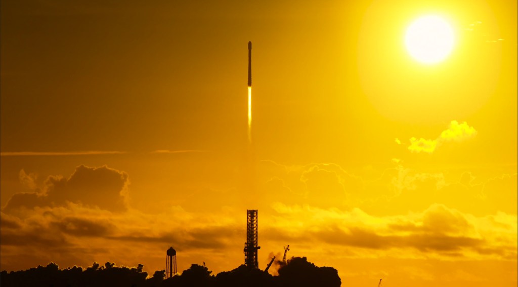
KENNEDY SPACE CENTER — SpaceX launched three satellites early Wednesday on a million-mile trip to tackle the mysteries of space weather, including how to protect from the sun’s disruptive and dangerous solar flares.
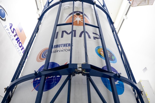
A Falcon 9 rocket lifted off from KSC’s Launch Pad 39-A at 7:30 a.m. carrying NASA’s Interstellar Mapping and Acceleration Probe (IMAP) with two rideshare satellites — NASA’s Carruthers Geocorona Observatory and the NOAA’s Space Weather Follow On–Lagrange 1 (SWFO-L1) satellite.
The first-stage booster made its second flight to space with a recovery landing downrange on the droneship Just Read the Instructions stationed in the Atlantic.
All three satellites were deployed less than two hours after liftoff.
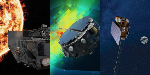
IMAP was the primary payload, with a scientific main objective to map the heliosphere but a secondary role to help detect potentially dangerous coronal mass ejections, more commonly known as solar flares. The NOAA’s SWFO-L1, though, is designed with solar flare detection and tracking as its main purpose.
The NOAA spacecraft will offer the U.S. for the first time 24/7 eyes on the sun and act as a warning system for geomagnetic storms from the ejections that have the potential to disrupt technology such as cell phone service, as well as damage the planet’s energy infrastructure.
A steady stream of that information is paramount to protect both earthbound interests, but also for astronauts and hardware in space.
“As the United States prepares to send humans back to the moon and onward to Mars with the Artemis program, NASA science is actively providing the ultimate interplanetary survival guide to help support humanity’s epic journey along the way,” said Nicky Fox, NASA’s associate administrator for its Science Mission Directorate during a mission briefing Sunday.
She explained how data from IMAP along with SWFO-L1 will be able to inform NASA’s human and robotic missions to avoid the dangers of solar flares. She cited a record-breaking one that the sun spat out in 1972 in between the Apollo 16 and 17 missions.
“The astronauts narrowly missed catastrophe when one of the most powerful radiation storms recorded since the Carrington event of 1859 occurred,” she said about the coronal mass ejection in August of 1972. “Had the astronauts been in orbit, or, in fact, on the moon’s surface, they could have experienced dangerous levels of high radiation sparked by the historically enormous solar flares bursting from the sun at unprecedented speeds.”
The same flare, which made the 93 million mile trip from the sun in a record 15 hours instead of the normal 2-3 days, wreaked havoc on Earth as well.
“The United States experienced radio blackouts, significant power grid disturbances, satellite damage, and those as far south as Texas saw spectacular aurora,” she said. “It also caused magnetic disturbances, which triggered the accidental detonation of U.S. naval sea mines from the Vietnam War.”
Liftoff! pic.twitter.com/elXj2RIhF2
— SpaceX (@SpaceX) September 24, 2025
All three satellites will be stationed in what’s known as a Lagrange point. Earth has five such points it shares with the sun as both bodies’ gravitational pulls allow for satellites to remain relatively stable, requiring less fuel to maintain their position in space. Lagrange Point 1 is in between the sun and Earth while Lagrange Point 2 is on the opposite side of Earth. LP2 is home to the James Webb Space Telescope, for instance.
The two NASA satellites will take about 108 days before they arrive to the L1 point and begin operations. The NOAA satellite will take a little longer, with operations targeting a start in April 2026.
The goals of all three satellites on this mission are to help better understand the effects of the sun on the solar system, including how far solar particles travel.
IMAP’s primary science mission is to study the sun’s particles and energy’s interaction throughout the heliosphere, which is the space affected by our star. Beyond the heliosphere is interstellar space.
“It’s a celestial cartographer,” said NASA’s Michele Cash, an IMAP deputy program scientist. “So it is trying to map out the heliosphere, this protective bubble that surrounds our solar system and can protect us from some of that incoming solar radiation. We want to understand what that looks like.”
She said understanding how solar particles work farther away from Earth will be essential as human space exploration continues to expand.
“So when we have missions that go beyond Earth’s protective bubble … they do experience much more severe space weather,” she said. “So energetic particles, this is the hazardous radiation that can come both from the sun, but from interstellar space as well.”
The Carruthers Geocorona Observatory will turn its attention to Earth, looking at its exosphere and how space weather hits the planet. It will image the ultraviolet light known as the geocorona, expanding on measurements first taken during the Apollo 16 mission in 1972. Its placement at L1 will allow for a view it cannot get from somewhere like geostationary orbit.
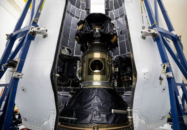
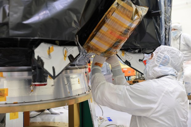
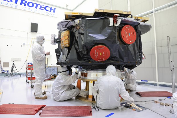
Technicians at Astrotech Space Operations Facility near NASA’s Kennedy Space Center in Florida encapsulate NASA’s IMAP (Interstellar Mapping and Acceleration Probe) spacecraft on Tuesday, Sept. 16, 2025, inside SpaceX’s Falcon 9 payload fairings to protect the spacecraft during launch. (Courtesy/SpaceX)
Show Caption
1 of 6
Technicians at Astrotech Space Operations Facility near NASA’s Kennedy Space Center in Florida encapsulate NASA’s IMAP (Interstellar Mapping and Acceleration Probe) spacecraft on Tuesday, Sept. 16, 2025, inside SpaceX’s Falcon 9 payload fairings to protect the spacecraft during launch. (Courtesy/SpaceX)
The NOAA’s SWFO-L1 spacecraft is part of a program that also had a tool that flew to geostationary orbit with the GOES-U satellite, which is used primarily to watch the eastern hemisphere from about 22,000 miles altitude.
But there are times of the year where the tool looking at the sun can’t see it, so some data was missing.
The SWFO-L1 is the first of three planned missions to 1 million mile altitude that will ensure an arsenal of solar protection detectors for the NOAA.
It has a 5-year mission life cycle plan, but enough fuel to last as many as 10 years. The NOAA has been relying on NASA and European Space Agency satellites launched in the 1990s to give them the majority of their solar flare data over the years.
“There was a dire need for them to be updated and upgraded also,” said the NOAA’ Dimitrios Vassiliadis, a SWFO-L1 program scientist detailing the new satellites suite of instruments. “These four instruments which are launched this week are modern instruments, and they have better capabilities than what was there before, so they will afford us faster, more reliable data that will serve both the forecasters and our numerical weather prediction models.”
But those are near the end of their lives, plus don’t deliver data back down to Earth frequently as they were designed for research, not direct utility.
SWFO-L1 data will come every 15 minutes, and it goes through the NOAA Space Weather Prediction Center, which then doles it out to customers who have come to rely on the information.
“We are a small but mighty office,” said its deputy director Brent Gordon. “There’s always somebody, at least one person, at the desk, keeping an eye on the sun, and they’re doing that for our customer base, which is is quite varied.”
One of its biggest customers has been companies that run constellations of satellites such as SpaceX’s Starlink and Amazon’s Project Kuiper.
A solar flare if strong enough can actually heat up the Earth’s atmosphere to the point that it expands to higher altitudes than normal. It may be just a little more dense particle-wise, but that will cause satellites that fly in low-Earth orbit to slow down as they begin to experience drag that they don’t normally experience.
The effect on GPS can also be a costly hazard for agriculture. Many farmers rely on it for pinpoint accuracy fed into agriculture machinery that knows the exact spot crops need to be planted and the followup care. With a jiggle in GPS, it can throw that machinery off. One agricultural economist estimated $500 million in damage was done during the 2024 solar flares that hit the U.S.
Gordon said that while solar flares have been hitting Earth for eons, it’s only in the last 60 years that it’s become a priority.
“Our technology has improved.” Gordon said. “At the same time, it’s become more susceptible to the impacts of space weather.”
That has included working with NASA since the Gemini program in the 1960s working closely with the NASA Space Radiation Analysis Group at Johnson Space Center in Houston.
“Their goal is to keep astronauts safe. Our mission is to give them the information they need to know to make the right decisions as to whether or not they need to protect humans in space or the if they can go about their normal mission,” he said. “We have daily calls with NASA to make sure we’re on the same page.”
That relationship will grow further as NASA ventures farther out.
“As we leave the protective cocoon of Earth’s magnetic shield, and we go outside the magnetic shield to the moon Mars, astronauts are going to be highly exposed to potential effects of space weather, namely radiation storms that the sun will sometimes unleash on us,” he said. “As Artemis has been coming back up, we’ve renewed our effort with them to make sure that we are getting them the right information at the right time.”
Our solar system sits inside a vast bubble shaped by the Sun known as the heliosphere. NASA’s IMAP mission will map its boundaries and transform how we understand our place in the galaxy. Launch day is Sept. 23! pic.twitter.com/O13LkEhVlq
— NASA 360 (@NASA360) September 20, 2025
The total cost for IMAP has been nearly $800 million, including development costs, launch vehicle costs and operations for a two-year prime science mission. The Caruthers Geocorona Observatory life cycle cost is $97 million.
The cost of the NOAA’s SWFO-L1 life cycle is $692 million, including concept to operations to eventual disposal. That cost includes an instrument already in use that was attached to its GOES-U geostationary orbit satellite that launched last year.
NASA is paying SpaceX $109.4 million to launch all three satellites.
Fox touted all three of Tuesday’s missions for their potential to provide real utility.
“All of these missions together support and enhance the existing space weather prediction capabilities and coordination with NOAA throughout our solar system in near real time for the benefit of all,” she said.
Originally Published: September 24, 2025 at 7:40 AM EDT