Staff reports
| The Arizona Republic
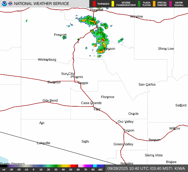
The National Weather Service issued flash flood warnings for the Phoenix area until 10:15 p.m. Sept. 27. The weather service also has issued thunderstorm warnings for the Phoenix area.
Flash flood warnings for Phoenix area
The weather service reported:
At 8:58 p.m., gauge reports indicated high flows and flooding on Indian Bend Wash. Flooding impacts will continue, but no additional rainfall is expected.
At 8:59 p.m., gauge reports indicated high flows and flooding on Sonoran Wash. Flooding impacts will continue, but no additional rainfall is expected.
Earlier, at 7:22 p.m., the weather service wrote:
“The National Weather Service in Phoenix has issued a Flash Flood Warning for, Maricopa County in south central Arizona, Until 10:15 p.m. MST. At 7:18 p.m. MST, Doppler radar indicated thunderstorms producing heavy rain across the warned area. Between 0.5 and 1 inch of rain has fallen. Additional rainfall amounts of 0.5 to 1 inch are possible in the warned area. Flash flooding is ongoing or expected to begin shortly.
HAZARD: Life-threatening flash flooding. Thunderstorms producing flash flooding.
SOURCE: Radar.
IMPACT: Life-threatening flash flooding of creeks and streams, urban areas, highways, streets and underpasses. Some locations that will experience flash flooding include: Phoenix, Scottsdale, New River, Cave Creek, Carefree and Desert Mountain. This includes the following highways: Loop 101 between mile markers 32 and 33; Interstate 17 near mile marker 224.
Earlier, at 6:54 p.m., the weather service wrote:
“The National Weather Service in Phoenix has issued a Flash Flood Warning for, Maricopa County in south central Arizona, Until 10 p.m. MST. At 6:47 p.m. MST, Doppler radar and automated rain gauges indicated thunderstorms producing heavy rain across the warned area. Between 0.5 and 1.5 inches of rain have fallen. Additional rainfall amounts up to 1 inch are possible in the warned area. Flash flooding is ongoing or expected to begin shortly.
HAZARD: Life-threatening flash flooding. Thunderstorms producing flash flooding.
SOURCE: Radar and automated gauges.
IMPACT: Life-threatening flash flooding of creeks and streams, urban areas, highways, streets and underpasses. Some locations that will experience flash flooding include: Phoenix, Scottsdale, Paradise Valley, North Mountain Park, Piestewa Peak Park, Deer Valley Airport, Desert Ridge Marketplace, Metro Center, Camelback Mountain and Arizona State Fairgrounds. This includes the following highways: Loop 202 between mile markers 1 and 2; Loop 101 between mile markers 22 and 31; Interstate 17 between mile markers 205 and 214; State Route 51 near mile marker 1, and between mile markers 10 and 15, and between mile markers 2 and 4; Interstate 10 between mile markers 144 and 148; State Route 303 between mile markers 138 and 139. This includes the following streams and drainages: Apache Wash, Indian Bend Wash, Cave Creek, Skunk Creek, New River and Salt River.”
Severe thunderstorm warnings for Phoenix area
At 7:29 p.m., the weather service wrote:
NWS update for metro Phoenix area, AZ: Severe Thunderstorm Warning: At 7:19 p.m. MST, severe thunderstorms were located along a line extending from 6 miles southeast of Black Canyon City to 7 miles northwest of Camp Creek to near Desert Mountain, moving north at 25 mph.
HAZARD: 60 mph wind gusts and penny-size hail.
SOURCE: Radar indicated.
IMPACT: Expect damage to roofs, siding, and trees. Locations impacted include: Scottsdale, New River, Cave Creek, Carefree, Desert Mountain, Camp Creek, and Seven Springs.
Earlier, at 7:01 p.m., the weather service wrote:
“The National Weather Service in Phoenix has issued a Severe Thunderstorm Warning for, Maricopa County in south central Arizona, Until 7:30 p.m. MST. At 6:55 p.m. MST, severe thunderstorms were located along a line extending from near New River to near Cave Creek to near Desert Ridge Marketplace, moving north at 20 mph.
HAZARD: 60 mph wind gusts and penny-size hail.
SOURCE: Radar indicated.
IMPACT: Expect damage to roofs, siding, and trees. Locations impacted include: Scottsdale, New River, Cave Creek, Carefree, Desert Mountain, Camp Creek, Black Canyon City Trailhead, Anthem, and Seven Springs. This includes the following highways: Interstate 17 between mile markers 222 and 241; Loop 101 near mile marker 35; State Route 74 between mile markers 28 and 30.”
Severe thunderstorm warning for Phoenix area
Earlier, at 6:33 p.m., the weather service wrote:
“NWS update for metro Phoenix area, AZ: Severe Thunderstorm Warning: At 6:28 p.m. MST, a severe thunderstorm was located over Piestewa Peak Park, or near Paradise Valley, moving north at 15 mph.
HAZARD: 60 mph wind gusts and quarter-size hail.
SOURCE: Radar indicated.
IMPACT: Hail damage to vehicles is expected. Expect wind damage to roofs, siding, and trees. Locations impacted include: Phoenix, Scottsdale, Paradise Valley, Piestewa Peak Park, downtown Scottsdale, Metro Center, Scottsdale Airport, Camelback Mountain, and North Mountain Park. This includes the following highways: Interstate 17 between mile markers 204 and 216; State Route 51 between mile markers 2 and 14; State Route 101 between mile markers 23 and 27, and between mile markers 38 and 49.”
At 6:12 p.m., the weather service wrote:
“The National Weather Service in Phoenix has issued a Severe Thunderstorm Warning for, Maricopa County in south central Arizona, Until 6:45 p.m. MST. At 6:06 p.m. MST, a severe thunderstorm was located over Sky Harbor Airport, or near Laveen, moving north at 15 mph.
HAZARD: 60 mph wind gusts and quarter-size hail.
SOURCE: Radar indicated.
IMPACT: Hail damage to vehicles is expected. Expect wind damage to roofs, siding, and trees. Locations impacted include: Phoenix, Scottsdale, Tempe, Paradise Valley, Laveen, Tempe Marketplace, Papago Park, Piestewa Peak Park, Arizona Mills Mall, Salt River Indian Community, North Mountain Park, South Phoenix, Arizona State Fairgrounds, Downtown Phoenix, and Downtown Scottsdale. This includes the following highways: Interstate 10 between mile markers 141 and 156; Interstate 17 between mile markers 195 and 216; State Route 51 between mile markers 1 and 14.”
Severe thunderstorm warning for Surprise, Buckeye
At 5:4 p.m., the weather service wrote:
“The National Weather Service in Phoenix has issued a Severe Thunderstorm Warning for, Maricopa County in south central Arizona, Until 6:15 p.m. MST. At 5:39 p.m. MST, a severe thunderstorm was located over Buckeye, moving north at 20 mph.
HAZARD: 60 mph wind gusts and quarter size hail.
SOURCE: Radar indicated.
IMPACT: Hail damage to vehicles is expected. Expect wind damage to roofs, siding, and trees. Locations impacted include: Surprise, Buckeye, Perryville, and White Tank Mountain Park. This includes the following highways: Interstate 10 between mile markers 107 and 121; State Route 85 between mile markers 152 and 154.”
Flash flood warning issued
At 4:20 p.m., the weather service wrote:
“The National Weather Service in Phoenix has issued a Flash Flood Warning for, Maricopa County in south central Arizona, Until 6:30 p.m. MST. At 4:13 p.m. MST, Doppler radar and automated rain gauges indicated thunderstorms producing heavy rain across the warned area. Between 0.5 and 1 inch of rain has fallen. Flash flooding is ongoing or expected to begin shortly.
HAZARD: Life-threatening flash flooding. Thunderstorms producing flash flooding.
SOURCE: Radar and automated gauges.
IMPACT: Life-threatening flash flooding of creeks and streams, urban areas, highways, streets and underpasses. Some locations that will experience flash flooding include: Buckeye, Painted Rock Dam and Arlington. This includes State Route 85 between mile markers 141 and 146. This includes the following streams and drainages: Hassayampa River, Enterprise Canal, Centennial Wash, Rainbow Wash, Gila River and Arlington Canal.”
For the latest watches and warnings, see our weather alert page.
Severe thunderstorm warning issued
A 3:11 p.m., the weather service wrote:
“The National Weather Service in Phoenix has issued a Severe Thunderstorm Warning for, Maricopa County in south central Arizona, Until 3:45 p.m. MST. At 3:01 p.m. MST, a severe thunderstorm was located 7 miles north of Cotton Center, or 16 miles southwest of Goodyear, moving north at 15 mph.
HAZARD: Quarter-size hail.
SOURCE: Radar indicated.
IMPACT: Damage to vehicles is expected. Locations impacted include: Buckeye, Palo Verde, Painted Rock Dam, Perryville, Hassayampa, and Arlington. This includes the following highways: Interstate 10 between mile markers 112 and 120; State Route 85 between mile markers 132 and 154.
 Tips for driving in the rain
The Arizona Department of Transportation provided the following safety tips for driving in the rain:
- Inspect windshield wipers and replace them if necessary prior to expected rainfall.
- Turn on the headlights.
- Reduce speeds.
- Avoid sudden braking on wet pavement.
- Create a “space cushion” between your vehicle and the vehicle in front of you.
- Avoid areas where water has pooled in travel lanes.
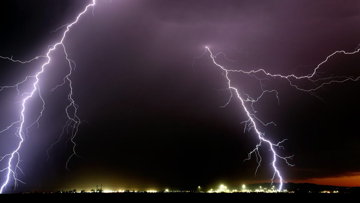
How to protect yourself from lightning strikes
Here are lightning safety tips from the National Weather Service:
- Pay attention to the weather. If you see big blue clouds, otherwise known as thunderheads, go inside. These types of clouds could mean a thunderstorm is coming.
- Get in a building with plumbing and wiring. If lightning strikes the building, the lightning will be conducted around and into the ground.
- Stay in your car. A vehicle will give you protection as electricity from lightning will pass through the vehicle’s structure instead of hitting you.
- Get off open water. A boat out on the water is likely to be the most prominent object and you could be struck.
- Do not shower or bathe. If lightning hits your pipes, it could be conducted into the water in your bath or shower.
- Do not use electric appliances with plugs or cords. Wireless cellphones are OK, as are laptops that are connected to Wi-Fi but not plugged in.
- Follow the 30-30 rule. If you hear thunder within 30 seconds of a lightning bolt, that means the thunderstorm’s distance is threatening. Wait at least 30 minutes after you hear the last thunder to go out. That gives the storm enough time to move away or dissipate.
- You don’t have to be near a storm to get struck. Lightning strikes can easily travel 10 miles or more. A record lightning flash in Oklahoma in 2007 traveled nearly 200 miles. Seek shelter if you hear thunder.
- Do not shelter under a tree. If lightning strikes the tree, the ground charge from the strike could travel into you.
- Don’t huddle in a group. If you are outdoors with friends or family during a thunderstorm, don’t all clump together. Keeping separation could reduce the number of people injured if lightning strikes.
This article was generated by The Arizona Republic and USA TODAY Network using data released by the National Weather Service. It was edited by a staff member.
(This story was updated to add new information.)