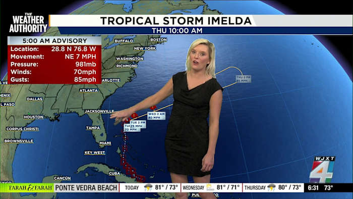
Imelda’s biggest impacts at the coast
JACKSONVILLE, Fla. – Tropical Storm Imelda is here, and if you’re heading to Jacksonville beaches today, you’ll notice the effects right away. I’m seeing gusty winds, rough surf, and the kind of choppy, “dirty” water that makes it tough for anyone—especially swimmers. The risks are high and not going anywhere soon.
The waves are running between 5 and 7 feet right now across our stretch of beach, and the Exact Track 4D radar backs it up with wave maps showing a lot of motion out there. A high risk of rip currents is in place for our entire coast. Please, if you aren’t a strong swimmer, stay out of the water. These conditions aren’t just tough, they’re dangerous.
The ocean just isn’t in a friendly mood, and I can tell you it’s going to stay this way for a while longer. The surf is rough, and it’s not the kind that tempts surfers—expect churned-up, messy breakers instead of clean lines.
Wind forecast: what to expect
As for the winds, they’re already whipping around the flagpoles at Morningstar Marinas and all along the coast. Right now, sustained winds are coming in between the teens and 20s, with gusts expected to reach 30 to almost 40 miles per hour along the beaches, especially in the morning.
Those gusty conditions are likely to continue as the day goes on. While things are breezier on the coast, winds are forecast to pick up further inland through the afternoon hours. It’s not the most comfortable day for a walk on the sand, and it could mean blowing sand or surprise gusts for anyone getting around outdoors.
Temperatures and storm chance today
Stepping outside early? Expect it to feel breezy and a bit cool, with temperatures at the bus stop right around 74 degrees. We’re likely to hit 84 degrees by 3 p.m., and while a few quick showers or storms may pop up, it looks like some sunshine could break through at times as well.
Not everyone will get wet today, but it’s smart to be ready for sudden changes, just in case. Most of our local area—from the city to beach to spots like Macclenny—are hanging in the low to mid-70s this morning according to the latest temperature map.
Safety is the main message
Above all, safety comes first. I know that windy, rough beach days can be disappointing, but these conditions could have been a lot worse. Still, when it’s this choppy and the rip currents are strong, the best move is to enjoy the beach from a safe spot out of the water.
If you’re seeing anything wild or dramatic out there—waves, weather, or just your own experience—share your pictures with us at SnapJAX! Stay tuned to News4JAX and The Weather Authority for continuous updates on Imelda, and keep checking Exact Track 4D for the latest conditions.
Copyright 2025 by WJXT News4JAX – All rights reserved.