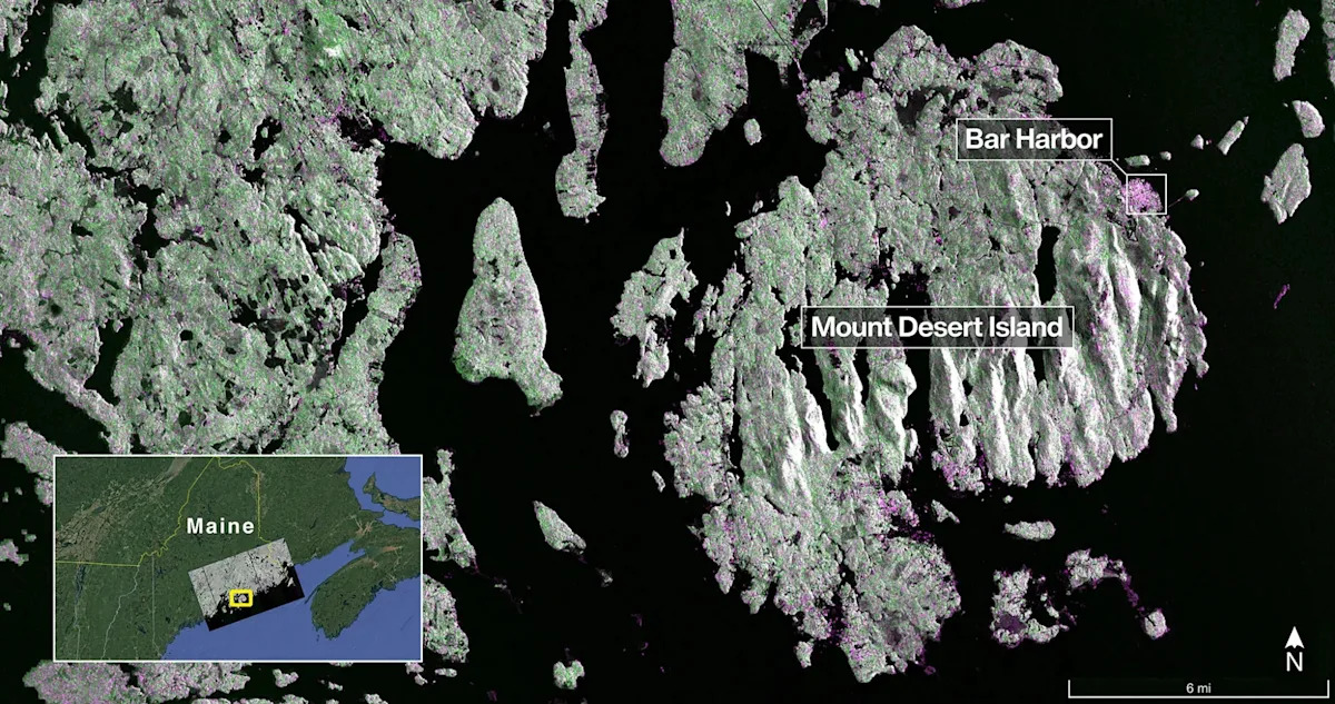
A new NASA Earth-observing satellite featured Maine’s coast in its first radar image.
The satellite, which was launched July 30, took the image of Maine on Aug. 21. It shows Mount Desert Island, an island off the north-central coast of Maine that’s home to Acadia National Park.
Dark areas represent water, while green areas indicate forests. Some spots in the image are also magenta, which indicate surfaces that are either hard bare ground or buildings. The magenta area on the northeast end of the island is Bar Harbor.

Captured on Aug. 21, this image from NISAR’s L-band radar shows Maine’s Mount Desert Island. Green indicates forest; magenta represents hard or regular surfaces, like bare ground and buildings. The magenta area on the island’s northeast end is the town of Bar Harbor.
It was one of two initial images shared by NASA: the other was of northeastern North Dakota.
The satellite, part of a collaboration between the United States and India called NISAR, is designed to observe and map Earth in incredible detail to provide scientists with measurements of some of the planet’s most complex processes – including disturbances to the ecosystem, collapses of ice sheets, rising sea levels and other natural disasters.
What is NASA’s NISAR mission with India?
The NISAR mission is a joint venture between NASA and the Indian Space Research Organization (ISRO.) The two space agencies are included in the NISAR acronym, which stands for NASA-ISRO Synthetic Aperture Radar.
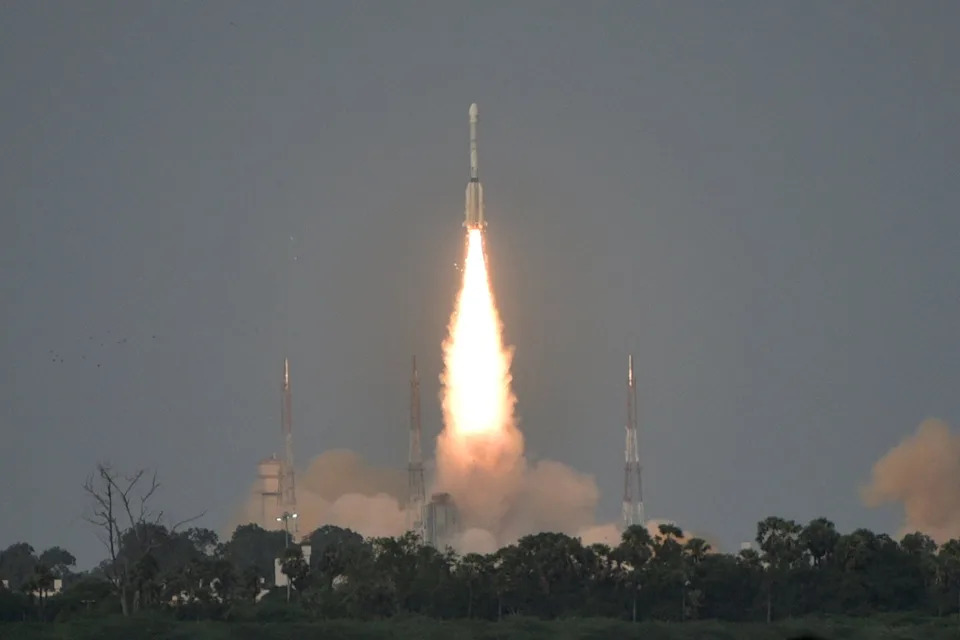
India’s Geosynchronous Satellite Launch Vehicle Mk II carrying the NASA-ISRO Synthetic Aperture Radar, or NISAR satellite, lifts off July 30 from the Satish Dhawan Space Centre in Sriharikota, India.
The goal of the mission is to provide data that will help people like scientists, farmers and emergency responders make decisions about things like agricultural management and infrastructure or form a disaster response plan.
See first radar images of Earth returned by NISAR satellite
In a late-September press release, NASA said the two radar images serve as a glimpse of just what the advanced observatory will be able to capture from space as it prepares to begin its full operation later in 2025.
“NISAR’s first images are a testament to what can be achieved when we unite around a shared vision of innovation and discovery,” acting NASA Administrator Sean Duffy said in a statement.
The NISAR satellite snapped the image of Maine on Aug. 21 using an instrument known as the L-band synthetic aperture radar (SAR) system. Provided by NASA’s Jet Propulsion Laboratory in Southern California, the L-band radar system uses a 10-inch wavelength with a signal that can capture objects as small as 15 feet.
The next image was captured Aug. 23 using the same L-band tool to survey a portion of northeastern North Dakota.
The area in question straddles Grand Forks and Walsh counties, detailing forests and wetlands on the banks of the Forest River that passes through the center of the frame. To the north and south of the river is farmland, with dark spots indicating fallow fields and lighter colors representing pastures or crops.
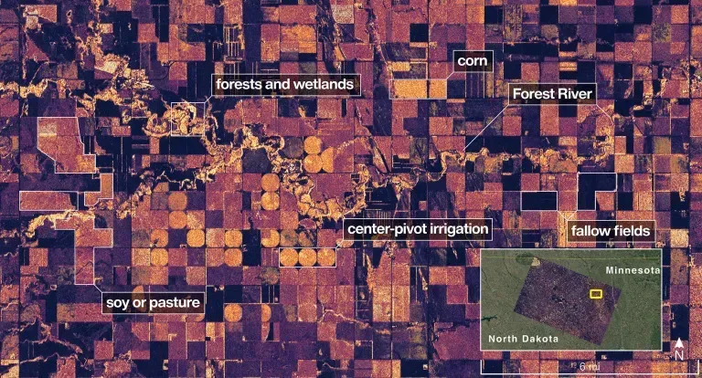
On Aug. 23, NISAR imaged land adjacent to northeastern North Dakota’s Forest River. Light-colored wetlands and forests line the river’s banks, while circular and rectangular plots throughout the image appear in shades that indicate the land may be pasture or cropland with corn or soy.
The NISAR mission also includes an S-band radar, provided by ISRO, that uses a 4-inch microwave signal to observe small vegetation.
What’s next for NISAR mission?
The debut images come after the NISAR satellite was raised to its operational 464-mile-high orbit in mid-September as it prepares to officially begin its science phase in November.
Once fully opearational, the satellite is intended to monitor Earth’s land and ice surfaces twice every 12 days, collecting data using the spacecraft’s 39-foot-wide drum-shaped antenna reflector.
“This is only the beginning,” Duffy continued in his statement. “NASA will continue to build upon the incredible scientific advancements of the past and present as we pursue our goal to maintain our nation’s space dominance through Gold Standard Science.”
Eric Lagatta is the Space Connect reporter for the USA TODAY Network. Reach him at elagatta@gannett.com
This article originally appeared on Portsmouth Herald: NISAR satellite’s first radar image is of Maine. See photos from space