JACKSONVILLE, Fla. – If you’re waking up to the sound of rain again, you’re not alone. Right now, a nor’easter is sweeping through Jacksonville and much of Northeast Florida, and it’s making its presence known.
Press play above to watch the live radar
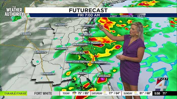
We’re seeing a whole lot of rain on Exact Track 4D radar, stretching across areas like Palm Coast, Fernandina Beach, Middleburg, and up into Waycross. There’s no need to hunt for puddles—they’ll find you today.
Winds are also kicking up, holding steady at about 18 miles an hour right now, with sustained winds in some spots reaching 29 miles an hour. That’s not just what you feel in the gusts—that’s a constant breeze you’ll notice along the coast and in open spaces.
With these conditions, there’s a real flood risk along the coast. A flash flood warning and a coastal flood advisory are in effect, plus a rip current risk for anyone thinking about heading to the beaches.
Weekend looks rainy, then brighter
What should you expect as we move into the weekend? Saturday brings a 50 percent chance of rain, with storms likely off and on all day. So, if you’re running errands or taking the kids to sports, keep the ponchos handy—they’ll thank you for it.
By Sunday, though, things are expected to start drying out. High pressure is on the way, and that’s going to push the clouds and rain north, giving us a chance to see some sun as we start the new week.
Temperatures are definitely cooler than average right now—Jacksonville is at 71 degrees, with Macclenny in the 60s and Waycross at 63 degrees. Once this system moves out, we’re forecast to bounce back to the mid-80s next week. Sunshine and a comfy breeze are both in the cards.
I always say: never totally rule out a stray shower, so I like to add a small rain chance each day, just in case Mother Nature wants to surprise us. But for now, the main story after the weekend should be mostly sunny skies.
Weather tips and a morning chuckle
I know sometimes the last thing you want is to talk about more dreary weather—it’s been a stretch of soggy mornings. If you’ve been juggling raincoats, umbrellas, and maybe packing a few extra snacks for a slow bus stop, hang in there! We’re almost through the worst of it.
And hey, if you spot something wild on your drive—like I did with the armadillo this morning—snap a photo and share it through SnapJAX! You never know, your weather moment might make someone’s day. Share at https://www.news4jax.com/snapjax/.
Remember, you can check the latest radar and updates anytime with The Weather Authority right here on News4JAX.
Copyright 2025 by WJXT News4JAX – All rights reserved.