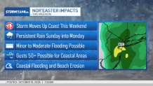
As a nor’easter makes its way toward the tri-state, communities are bracing for potentially severe impacts — including powerful winds, persistent rain and the chance for coastal flooding.
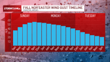
After some stray showers Saturday afternoon, the weather starts to deteriorate throughout the day on Sunday, with coastal winds becoming strong quickly.
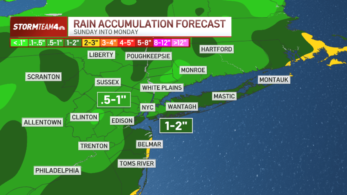
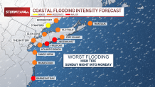
The nor’easter is expected to impact the tri-state Sunday into Monday, with the main concern being coastal flooding and erosion.
At this time, the coastal flood watch is expected to mostly impact the Jersey Shore, Long Island, New York City and parts of Connecticut Sunday and Monday because of strong onshore winds and rough surf with anticipated swells and waves reaching up to 20 feet. Coastal inundation could reach up to three feet due to strong onshore wind and rough surf.

Inland flooding is not likely to take place, according to the latest forecast, given that the rain will be spread out over two days. However, the rainfall total is quite significant with 1-2 inches widespread, although 2-3 inches could take place in some areas.
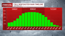
The most significant rainfall is expected to take place Sunday through Monday. It will be a nuisance for much of that time, and could take most of the day Sunday before reaching NYC.

Wind gusts of up to 60 mph are expected late Sunday into Monday — although inland gusts will be lower, but downed trees and power outages will be possible. Long Island, NYC and the Jersey Shore are most likely to see the high winds.
Gusts inland won’t be as bad, but still strong, between 30-40 mph, meaning downed trees and power outages will be possible.

Expect some low-lying coastal roads to be impassable due to flooding at high tide starting Sunday evening. Elsewhere, inland roads will be slick with rain and falling leaves. Bridges/elevated roads near the coast will be very windy and restrictions are likely.
Expect large airport delays from Boston to D.C. due to this storm.
The expected severe weather has prompted New Jersey to make preparations to declare a state of emergency ahead of the nor’easter. The State of Emergency will begin 10 p.m. Saturday.
“Starting on Sunday, a dangerous coastal storm will begin to move past our state with extreme weather conditions for several counties, especially those on the Shore,” Acting Governor Tahesha Way said in a statement. “In preparation for this storm, I am issuing a State of Emergency for all 21 counties out of an abundance of caution, authorizing our state’s emergency services personnel to activate as necessary. I urge all New Jerseyans to exercise caution, monitor local weather forecasts and warnings, stay informed on evacuation protocols, and remain off the roads unless absolutely necessary.”
The storm will still be in our vicinity off the coast through early Tuesday. However, by later Tuesday and Wednesday, the weather calms down. Tuesday will be very breezy, but the rain will taper off and we’ll feel the transition to calmer weather as the low pressure system weakens and migrates east.