SAN ANTONIO – NOTE — This story contains images of vehicles being swept away by June 12, 2025, flooding at Beitel Creek.
More than two-and-a-half weeks after 13 people died in flooding around San Antonio, questions of “how” and “why” still lack clear answers.
Using video shot on June 12 and information provided by the San Antonio Fire Department, KSAT has created an interactive map to better visualize the chaos of the deadliest flooding site: Beitel Creek.
In all, about 15 cars were swept away and 11 people were killed along a roughly 1.5-mile stretch on the Northeast side, near Loop 410 and Perrin Beitel Road.
The map below relies on data generated by Texas A&M Task Force 1, a federal team that helped with some of the rescue operations. However, the map currently includes the exact recovery locations for only nine victims and might not include all the recovered vehicles.
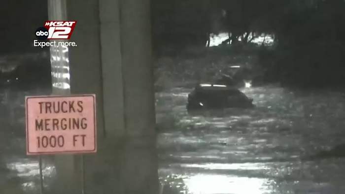
15 vehicles swept away at Loop 410KSAT captured this video of two cars floating off the Loop 410 westbound access road and into Beitel Creek during the June 12, 2025 flooding (KSAT)
Beitel Creek on the Northeast Side crosses under Loop 410 near the Interstate 35 interchange, just east of Perrin Beitel Road.
At least 15 vehicles are believed to have been swept off the access road — most, if not all, from the westbound lanes.
At about 5:20 a.m., KSAT cameras caught two of the vehicles being carried off by the high waters and were pulled into the much swifter waters of the creek.
At about the same time, KSAT recorded a person wading along the same flooded road in an apparent attempt to get to higher ground. However, the camera did not capture the person either making it to dry land or being swept away.
A figure is seen walking away from the water about 45 seconds after the initial person disappears from frame, but it is unclear if it is the same person.
NOTE — All distances noted are from Loop 410 rather than an exact spot along the access road.
Concrete-Lined Channel: 0.0 — 0.4 miles downstreamA security camera from a building next to Beitel Creek, inside Loop 410, captured video of vehicles careening downstream (Courtesy)
The largely natural creek bed of Beitel Creek narrows to a concrete-lined channel at Loop 410 and shoots southward, parallel to Perrin Beitel Road.
Security video from a building on the west bank of the channel shows cars careening past, with their tail lights bobbing helplessly.
Below Vicar Drive, vegetation grows in the middle of the channel while concrete still holds the sides.
After the creek turns westward and under Perrin Beitel Road, the channel widens and reverts to a fully natural creek bed.
Low-water crossing: 0.3 miles downstreamDrone video looking upstream at Beitel Creek shows concrete rubble piled against the low-water crossing at Vicar Drive after deadly flooding on June 12, 2025 (KSAT)Concrete and rebar ripped off the channel wall of Beitel Creek inside Loop 410 piled against a low-water crossing at Vicar Drive (KSAT)
Concrete panels and their embedded rebar were piled high against the low-water crossing at Vicar Drive.
Built to withstand water running over the top, the crossing also has culverts underneath.
However, as the concrete lining the channel upstream was ripped off the bank, much of it got caught against the roadway. After the waters receded, the debris was piled on the path.
Rescues: 0.5 — 0.75 miles downstreamA man clings to a tree in Beitel Creek amid flooding during June 12, 2025. (KSAT)
In response to the flooding, the San Antonio Fire Department set up rescue operations at the Briar Glen Trailhead, located west of where Perrin Beitel Road crosses Beitel Creek.
People washed away by the high waters clung to trees and bushes as they waited for SAFD crews in red helmets and yellow, high-visibility vests to pull them to safety in small boats.
SAFD said its crews rescued 10 people and another two were able to escape the water themselves.
Of those 12 people, the SAFD said four required treatment at the hospital for minor injuries.
Vehicles found: 0.4 — 0.9 miles downstreamMost of the cars swept away in Beitel Creek came to rest near the Perrin Beitel Road bridge after the June 12, 2025 flooding (KSAT)
Most of the vehicles came to rest in the immediate area around the Perrin Beitel Road bridge, though at least one made it near where Beitel Creek merges with Salado Creek.
Video from after the water receded showed the vehicles damaged by the banks, bridge and other debris in the water.
A nearly unrecognizable red vehicle was wrapped around a concrete pillar at the Perrin Beitel Road bridge.
Victims recovered: 0.5 — 1.3 miles downstreamSan Antonio flooding victims (KSAT)
The afternoon after the flooding, the SAFD announced that at least five people had died and at least two were still unaccounted for.
Shortly after noon on June 14, two days after the flooding, the department confirmed the bodies of 13 people had been recovered at the various flooding sites.
The 11 people who died on Beitel Creek ranged from 28 to 77 years old: Carlos Valdez III, 67; Martha De La Torre Rangel, 55; Esther Chung, 77; Victor Manuel Macias Castro, 28; Matthew Angel Tufono, 51; Cristine Gabrielle Gonzalez, 29; Rudy Garza Jr., 61; Josue Jeziel Pina de la Torrre, 28; Andrew Martinez Sanchez, 60; Brett Howard Riley, 63; Stevie DeWayne Richards, 42; Derwin Jerome Anderson Jr., 43.
Rosann Elaine Cobb, 41, was found in the Wurzbach Parkway area and Derwin Jerome Anderson Jr., 43, was recovered near U.S. Highway 90 and Callaghan Road.
A map shared by SAFD shows the exact locations where nine people, and what appears to be 14 vehicles, were recovered along Beitel Creek.
An SAFD spokesman said the map uses GPS data from Texas A&M Task Force 1 and only reflects the locations of victims recovered with their help and not anyone located by SAFD.
The department did not have the GPS tracking “used early on in the response.”
A City of San Antonio Office of Emergency Management map used data from Texas A&M Task Force 1 to map exactly where nine victims and what appears to be 14 vehicles were recovered on Beitel Creek after the June 12, 2025 flooding. (City of San Antonio)
KSAT does not have any information to indicate which recovery location pertains to a specific victim.
More recent coverage of this story on KSAT:
Copyright 2025 by KSAT – All rights reserved.