The coastal low that brought several days of rain, wind, and rough surf to the Jersey Shore will begin moving east overnight into Tuesday.
That same system that caused the damp, breezy conditions in the Philadelphia area will gradually weaken and merge with the main low off the Carolina coast as it drifts farther out to sea. Rain will taper off from northwest to southeast overnight, though drizzle and gusty winds along the coast will likely continue through early Tuesday.
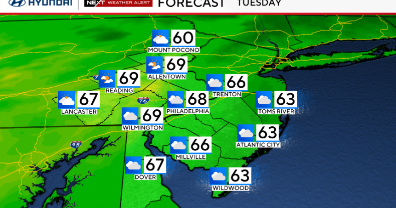
Conditions will improve Tuesday as drier air moves in from the west. Clouds may linger early but should begin to break during the afternoon, allowing for some sunshine to return. Winds will remain breezy at times with gusts around 20 to 30 mph, and highs will reach the mid to upper 60s.
A cold front will move through on Wednesday, bringing a fresh push of cooler air. Temperatures will range from near 70 in southern areas to closer to 60 farther north, with lows dropping into the 30s and 40s Wednesday night.
Thursday will feel noticeably cooler and breezy under mostly sunny skies, with highs holding in the upper 50s to low 60s. A light freeze is possible across parts of the Poconos and northern New Jersey if winds ease enough overnight into Friday morning. High pressure will then settle over the region Friday and Saturday, bringing two dry and pleasant days with gradually moderating temperatures.
By Sunday, clouds will increase as the next weather system approaches from the west. Showers are possible Sunday night into Monday, and a few thunderstorms could happen. Temperatures will be above normal Sunday before trending cooler again early next week.
Here’s your 7-day forecast:

CBS Philadelphia
Tuesday: Cloudy. High 68, Low 56.
Wednesday: Sun returns. High 71, Low of 55.
Thursday: Sunny, cool. High 65, Low 46.
Friday: Sunny. High 65, Low 42.
Saturday: Sunny. High 73, Low 51.
Sunday: Partly cloudy. High 79, Low 58.
Monday: Scattered showers. High 67, Low 56.