40m agoTue 1 Jul 2025 at 7:46pmWeather warnings in place across NSW

Here is a list of the hazard warnings the SES currently has in place across New South Wales:
Emergency-level warnings:
Watch-and act-level warnings:
There are also various Advice-level warnings still in place, which you can check via the link below:
10m agoTue 1 Jul 2025 at 8:17pmNew Watch and Act warning for Lake Conjola
We’ve just received word in the past few minutes about an updated weather warning for parts of Lake Conjola.
The NSW SES has issued a Watch and Act alert for flooding in low-lying areas and roadways around the lake.
The alert area extends from the coastline south of the Narrawallee Creek Nature Reserve, up to western parts of Bendalong and Manyana and out to Conjola Park, Fishermans Paradise and past Hill Top.
You can see the full detail of that warning, here:
14m agoTue 1 Jul 2025 at 8:12pm
A look at the rain radar
Heavy rain continues to fall in multiple parts of NSW.
As the Bureau of Meteorology has been telling us so far this morning, a lot of it continues to come down off the coast of Sydney and the NSW South Coast.
To give you an idea of just how widespread this bomb cyclone weather system is, this is the latest BOM rain radar as of the top of this hour:
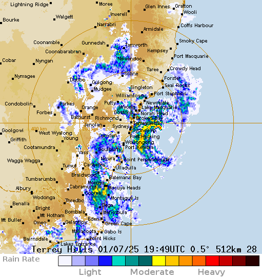 (Supplied: BOM)17m agoTue 1 Jul 2025 at 8:09pmDriver taken to hospital as trees fall on power lines at the foot of the Blue Mountains
We’ve been told a motorist had to be taken to hospital after a large tree fell on their car and brought down power lines in Cranebrook, at the foot of the Blue Mountains, during the night.
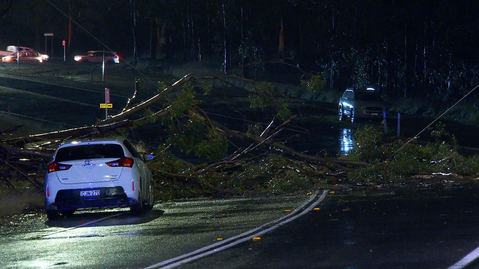 (ABC News)
Emergency authorities say they were called to The Northern Road and took the driver to hospital with minor injuries.
Similarly damaging winds seem to have had an impact at Lapstone, where roads have been cluttered through the night by downed trees and debris.
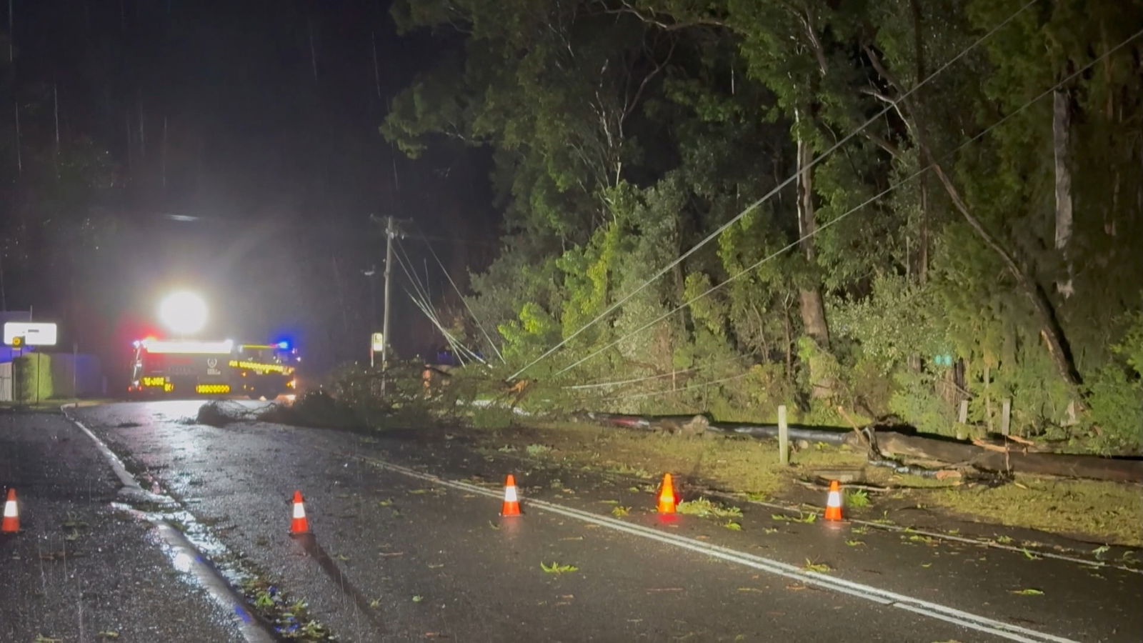 (ABC News)
The severe weather has also hit further east at Sydney Airport, where delays continue this morning.
 (AB CNews)
27m agoTue 1 Jul 2025 at 7:59pm
Train wiring damaged by downed trees on NSW Central Coast
As we’ve been reporting, parts of the state have been lashed through the night by significant wind gusts.
Earlier, Transport for NSW released this image to show those winds have caused damaged to overhead wiring along a train line at Koolewong, on the NSW Central Coast.
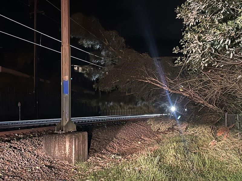 Damaged overhead train line wiring at Koolewong has sparked service delays. (Supplied: Transport for NSW)
32m agoTue 1 Jul 2025 at 7:54pm
Huge surf swells recorded along NSW coastline
The bomb cyclone weather system has also brought with it significant surf swells off the coast of NSW.
The Bureau of Meteorology has a Coastal Hazard Warning for damaging surf conditions still in place this morning.
It says damaging surf could lead to coastal erosion and damage to infrastructure in parts between Seal Rocks and the Illawarra, right down to the border of Victoria until Thursday.
The BOM also says:
- A 6.4m wave was recorded at Port Kembla.
- A 6.6m wave was recorded at Batemans Bay.
- A 6.4m wave was recorded at Eden.
37m agoTue 1 Jul 2025 at 7:50pm
‘Too late to leave’ for some in the Illawarra: SES
It is too late for some Illawarra and South East regions to leave their homes ahead of possible flooding, as evacuation routes are likely cut off.
 (ABC News: Danielle Bonica)
The SES is warning people living in low-lying areas on both the north and south side of Burril Lake should shelter now.
Another SES warning is current for those in low-lying parts of Sanctuary Point, such as Mountain Street, parts of Larmer Avenue and The Park Drive, should move to higher ground.
Further north on the Central Coast, the SES said homes identified for possible coastal erosion risk at North Entrance and Wamberal should also evacuate.
49m agoTue 1 Jul 2025 at 7:38pmTens of thousands of home still in the dark
As the state wakes up from another night of storms, more than 29,400 homes are without power.
 (ABC News: Curtis Rodda)
In Sydney’s north, the Central Coast and Newcastle regions, Ausgrid lists 10,382 customers experiencing unplanned outages due to fallen trees and downed power lines.
For Endeavour customers in the Blue Mountains, Western Sydney, Illawarra and South Coast regions, 16,904 homes are waking into darkness.
Essential Energy, which provides power to the remainder of the state, reported 2,141 homes had unplanned outages this morning.
Due to the large volume of homes without electricity, energy providers are providing estimates about when line workers will be able to restore power.
50m agoTue 1 Jul 2025 at 7:36pmHow much rain has fallen in parts of NSW?
We’ll stay across all of the latest weather observations made available to us from the Bureau of Meteorology as the morning progresses.
We can currently see that since 9am yesterday:
- In the Hunter: 20.6mm of rain has fallen in Gosford, 22.8mm at Maitland Airport, 29.4mm at Murrurundi Gap, 23.2mm at Scone Airport and 22mm at Tocal and Williamtown.
- In Sydney: 44.8mm of rain has fallen at Badgerys Creek, almost 50mm at Bankstown, 55mm in Camden, 60mm in Campbelltown, 64mm at the Holsworthy Barracks and more than 70mm at Sydney Airport.
- In the Illawarra: More than 154mm of rain has fallen at Nowra, 145mm in Jervis Bay, 130mm at Kiama and 123mm at Moss Vale.
- On the South Coast: More than 126mm has been recorded at Moruya Airport, 108mm at Montague Island and 22mm at Ulladulla.
58m agoTue 1 Jul 2025 at 7:28pmThe latest weather information from across NSW
The Bureau of Meteorology still has a severe weather warning in place, impacting multiple regions of NSW.
The BOM says: “A vigorous coastal low-pressure system is currently located offshore the northern Illawarra, and is forecast to gradually track northeastwards into the Tasman Sea later today.”
That “bomb cyclone” weather system has resulted in heavy rain, mostly south of Nowra to Bega, and damaging south to south-westerly winds of up to 100kph in coastal areas.
The latest information we have about the most-impacted areas through the night shows:
- 80.5mm of rain fell at Oranmeir to 2:05am.
- 108mm of rain fell at Nowra to midnight.
- 133mm of rain fell at Morton to 11:43pm.
- 116mm of rain fell at Vincentia to 9:37pm.
- 121mm of rain fell at Greenwell Point to 9:10pm.
- 112mm of rain fell at Currarong to 8:42pm.
- Wind gusts in excess of 100kph were recorded at Jervis Bay Airfield, Point Perpendicular, Ulladulla and Penrith
1h agoTue 1 Jul 2025 at 7:21pm
Good morning
Welcome to our live coverage of the unfolding weather situation across parts of New South Wales.
A severe weather warning remains in place for large parts of the Hunter region, Sydney, the South Coast and areas around Coffs Harbour.
We’ll keep you up to date here with all of the latest information as we receive it.