High pressure builds to our south overnight, allowing skies to clear and winds to relax in the Philadelphia area. Conditions will be calm and cool, with lows in the 30s across the Poconos and northwest New Jersey, and 40s elsewhere.
After a breezy day, the air mass has dried out enough to prevent fog concerns overnight.
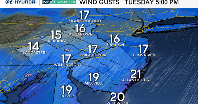
On Tuesday, winds shift back to the southwest and strengthen ahead of the next cold front. Temperatures rebound into the upper 60s to near 70 under increasing clouds later in the day. Rain will hold off until after sunset as the front approaches from the west.

CBS News Philadelphia
The front crosses Tuesday night into Wednesday morning, bringing scattered showers and light rainfall. Behind it, cooler and breezy northwest winds develop with gusts near 25 mph. Highs Wednesday will drop back into the 50s and 60s. Another weak cold front moves through late Thursday with only a few spotty showers before high pressure returns Friday, bringing sunshine and cooler, calmer weather into the weekend.
Here’s your 7-day forecast:

CBS News Philadelphia
Tuesday: Plenty of sun. High 73, Low 45.
Wednesday: Early shower, then sun. High 66, Low of 52.
Thursday: Cool, sunshine. High 64, Low 48.
Friday: Sunny skies. High 62, Low 44.
Saturday: Partly cloudy. High 62, Low 42.
Sunday: Increasing clouds. High 64, Low 43.
Monday: Chance of showers. High 63, Low 47.