
Scroll down to play live radar.
Storms are rolling through several parts of North Texas on Saturday evening.
Central Texas was expected to see strong and severe storms accompanied by hail and damaging winds, according to the National Weather Service. North Texas might see low coverage of storms.
There was a 30% chance of showers and thunderstorms in the Dallas-Fort Worth area after 1 p.m. on Saturday. Heavy rainfall may increase the chance of flooding in certain areas.
D-FW Weather Wise
Related

The weather service reported that a cluster of storms moving into Johnson County is moving to the northeast. This might impact central and eastern portions of the D-FW metropolitan area on Saturday afternoon.
Lightning strikes were observed on radar as far north as Burleson.
A large portion of north-central, northeast and south-central Texas is under flood watch until 10 p.m.
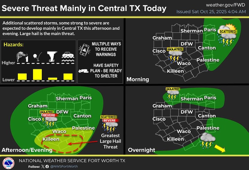
Chances of scattered storms in Central Texas on Saturday afternoon.
National Weather Service
Roughly 20,000 people in North Texas were still without power Saturday morning after severe storms swept the region overnight.
Most of those without power are in Tarrant County, according to Oncor’s outage map. About 2,800 Oncor customers in Dallas County did not have power, while 18,000 in Tarrant County remained without power as of 8:30 a.m.
Since Thursday, Dallas-Fort Worth International Airport has received about 3 inches of rainfall. Fort Worth saw 4.6 inches of rainfall, according to the NWS.
Related

The power outages come after the Fort Worth office of the NWS issued several severe thunderstorm warnings Friday night. A tornado warning was also issued in Parker County, and the weather service said it was looking into reports of a possible tornado in Fort Worth.
A statement from the weather service said wind damage was reported during the storm, and it is unknown yet if a tornado occurred. The weather service asked on social media for anyone affected by the storm to send in damage reports.
Latest Dallas forecast via KXAS-TV (NBC5):
SATURDAY: Mostly cloudy with a few scattered afternoon showers and thunderstorms. High: 75. Wind: WSW 5-10 mph.
TONIGHT: Scattered evening showers and thunderstorms exit, gradual clearing overnight. Low: 60. Wind: WSW 5 mph.
SUNDAY: A mixture of sun and clouds, mild. High: 76. Wind: NW 5-10 mph.
MONDAY: Mostly sunny and mild. Low: 60. High: 80. Wind: SE 10-15 mph.
TUESDAY: Sun, clouds and slightly cooler. Low: 59. High: 70. Wind: N 10-15 mph.
WEDNESDAY: Mostly sunny and cooler. Low: 50. High: 64. Wind: N 10-15 mph.
THURSDAY: Mostly sunny and pleasant. Low: 48. High: 68. Wind: E 5-10 mph.
FRIDAY: Mostly sunny and pleasant. Low: 49. High: 69. Wind: NE 5-10 mph.