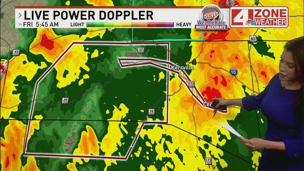
SAN ANTONIO – A FLASH FLOOD EMERGENCY has been extended along the Guadalupe River from Hunt to Kerrville down to Center Point to now include parts of Kendall County, north of Boerne.
The Flash Flood Emergency is extended until 2 p.m.
The Kerr County Sheriff’s Office has confirmed fatalities from what it is calling a “catastrophic flooding event” in Kerr County.
Officials said there are missing people and they are blocking off West Church to prepare for helicopters.
Kerrville Police and Fire Department crews are actively evacuating residents as widespread flooding affects large portions of the city.
RELATED: Fatalities confirmed in catastrophic Kerr County flooding; disaster declaration issued
Slow moving thunderstorms and showers are dropping heavy rain in the Hill Country.
The National Weather Service reports that the Guadalupe River at Hunt is rising rapidly, now at its second-highest level on record—surpassing the 1987 flood. This flood wave is expected to continue moving through Kerrville and Comfort.
Guadalupe River Hits Record Levels
The Guadalupe River in Hunt is rapidly rising and nearing record levels. The all-time record is 36.6 feet, and as of 5 a.m., the river is already at 34 feet.
Nearly 10 inches of rain fell overnight between Leakey and Ingram, according to radar estimates. As a result, major flooding is expected along the Guadalupe River.
In Kerrville, the river is forecast to rise to 31.8 feet by 8 a.m., while in Comfort, it’s expected to reach 30.6 feet by 2 p.m.—including a sharp 17-foot rise between 10 and 11 a.m. Widespread damage is likely along the river as the floodwaters move downstream.
RELATED: Guadalupe River flooding leaves Kerrville homes devastated, rescue efforts underway
From the National Weather Service:
This is a very dangerous and life-threatening flood event along the Guadalupe River!
Stay safe. Avoid flood-prone areas and monitor local alerts.
CLICK HERE to track storms with interactive radar
Flood Watch Extended for the Hill Country Until 1 PM Friday
Heavy rain is expected to continue, with potential flooding in low-lying areas, along rivers and creeks, and at low water crossings. Rainfall totals of 1 to 3 inches are likely, with isolated areas seeing up to 5 to 7 inches.
The rain chance lowers to 10% through 7pm. Firework shows should be in good shape based on latest data trends but will be keeping an eye for any changes.
TURN AROUND DON’T DROWN
Even just six inches of fast-moving floodwater can knock you off your feet—and two feet can carry away a car. Never try to walk, swim, or drive through floodwaters.
If you see a flooded road, stop and turn around. Find a safer route.
Turn around—don’t drown. Most flood-related deaths happen in vehicles.
CLICK HERE for full forecast.
CLICK HERE to send us your weather photos or video.