SYRACUSE, N.Y. —
When you’re trying to sleep Saturday night you may be woken up by some thunderstorms. A few of those thunderstorms could be strong to severe and able to cause tree and property damage.
Here is the latest setup in the atmosphere that will allow storms to not just generate, but sustain their energy and movement while the sun is down:
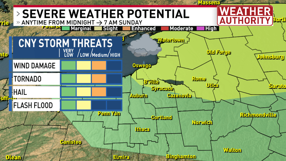
This is the outline of timing and potential impacts to CNY overnight:
In the event any SEVERE THUNDERSTORM WARNINGS or TORNADO WARNINGS become issued here are some safety reminders for both:
Let’s look at one of our higher resolution computer models that gives a very strong outlook towards severe storms tonight:
This of course is just one model out of many that our Weather Authority team is looking at tonight. Some models keep the storms mostly east of Interstate 81 out across the Mohawk Valley in parts of Oneida, Madison and Chenango counties.
Please be sure to view our news at 6 PM, then again at 10 PM on CW6 and most importantly to watch the news at 11 to see where any storms are beginning to develop just to our north and northwest.
Have a plan if you lose power as you can still watch our newscasts on our CNY Central mobile news app as well as right here on cnycentral.com using your smart phone or tablet.