Widespread snow, slick travel Wednesday in Vermont and Northern New York
Now NBC 5’s certified most accurate forecast. Needed the parka and the gloves again today. I mean, it is winter. It’s, uh, you know, in, in some ways the most intense start to winter since 1989. That’s before our time. It is before. What? You didn’t let me finish. Go ahead. We’re talking about our time here on the anchor desk. Yeah, sure you are. Actually, that’s even before Tom Messner’s time. He was, uh, he started in 1990, so. Uh, look at the lows this morning, -24 in Saranac Lake. That tied the record. It’s hard to set new records nowadays. We set *** new one in Plattsburgh, -11, *** new record, -15 Messina, and this is the stat we were crunching last night in Burlington. We’ve had three days below zero so far, December 5th, 8th, and today the 9th. That is the most subzero cold in 36 years. You got to go back to 1989. 1989 had 5 subzero days so far, and there’s only *** handful of years in the whole record book uh with this much intense cold so early, so we’re feeling it, that’s for sure. It’s 7 and snow right now, but notice there’s no minus signs right now and we’re not really thinking any subzero cold tonight because there’s clouds and snow showers moving through. It’s hard to be. Cold when you have clouds overhead, so *** few roads may get slick tonight, but big picture, it’s really this system here over Minneapolis that comes in tomorrow. We’ve added the wind flow here. See, it kind of moves along to the east and then it’ll come right up over us for tomorrow. So alert weather for Wednesday, not because it’s *** blockbuster storm, but because the roads will be slippery *** lot of the time. So *** little snow shower this evening. But kind of quiet for most of the morning commute and then by 89, 10 o’clock, the snow really comes in tomorrow, heavy at times in that late morning time frame. Now temperatures are near 32, so it’s *** wet snow. I think the biggest of roads like 87, 89, 91 with enough traffic and enough treatment, maybe they try to go towards *** wet condition for *** time. And then back to snowy, but I think with some elevation this is really going to be *** snowy situation on the roads tomorrow. By Thursday, sun and mountain snow and wind as we go through the whole day and then Friday turns out to be ***, *** quieter day. So how much snow we’re thinking *** couple of inches in the Champlain Valley. We’ll zoom in here. Uh, dusting to 2 inches right along the lake shore, maybe 2 or 3 up by Alberg, 4 inches in between Malone and Saranac Lake, *** foot on Marcy, right in the Tri-lakes, more like 2 to 4 inches, could be 4 to 8 inches on the south. Southeastern side of Tupper Lake, there’s some down sloping effects, so that’s why these totals vary so much. Burlington is not going to be much, maybe 2 inches in Burlington of *** very wet snow, but look at the 4 to 8 inches here for the Mad River Valley up towards the Northeast Kingdom. So that is where the road conditions will be toughest as we go through tomorrow, especially for the evening commute. Couple of pockets of 8 inches in the mountains of southern Vermont. So that’s why we’ve got the red color for tomorrow. Notice the, uh, mountain snow continues on Thursday. Friday and Saturday looking pretty good. 30 is going to feel OK after what we’ve just gone through. That’s for Saturday. Snow shower Sunday. There is another shot of cold early next week, single digits, probably some subzero stuff in the colder parts, but there are *** few signals for *** warm up either late next week, maybe more so the Christmas week. And if that were to happen with *** storm well north and west of us, there could be some rain in play. So we’ll keep an eye out for that as we get closer, but for now, right now, the roads are cold. That means when this snow comes in, should stick right away, right, Andrew? Yes, Tyler, absolutely no shortage of cold the last couple of days, so the pavement temperature very chilly right now. We’ll show you the dash cam footage. It’s dry, just bare pavement, but the air temperature 19, and as we show you the tire cam kind of dark right now, but just dry ground, but the pavement about 23 degrees way below the freezing mark. So even as the snow comes in in the Champlain Valley, slick travel expected. Tomorrow we’ll show you the traffic maps. Road weather index looking fine across the region. Traffic flowing at *** good clip in northern New York. Northern Vermont just fine on I-89 and 91. Southern Vermont, no issue, including Route 7. But travel impacts for tonight looking low with just some patchy light snow adjusting to 1 inch in some towns. The morning commute tomorrow moderate impact because the snow is. Just filling in 5 to 7 a.m. Northern New York into southern Vermont. 7 to 9 a.m. the snow comes into the Champlain Valley in northern Vermont and then for the p.m. commute, high impact, still some slick travel left on the side roads in the high terrain, especially with some lingering areas of light snow. So this is the latest here in South Burlington right near our studio. Brian and Liz, back to you.
Widespread snow, slick travel Wednesday in Vermont and Northern New York

Updated: 11:35 PM EST Dec 9, 2025
The NBC5 First Warning Weather Team is tracking widespread snow and slick travel conditions across Vermont and Northern New York on Wednesday, Dec. 10 that could make for a slippery evening commute. After sunset Tuesday, an initial band of patchy light snow moves in ahead of the steadiest snow arriving mid-morning Wednesday.Snow will come down heavily in the Champlain Valley through late morning Wednesday before tapering off, thanks to a downsloping wind that cuts into afternoon totals. Meanwhile, the rest of Vermont and northern New York will hold onto heavier snow—and even a bit of rain at times—through much of the day.Because temperatures will be near freezing, the mix of snow and rain will make for slick and slippery travel conditions, so drivers should use caution on the roads.Estimated Snow TotalsAs of Monday, the Champlain Valley is only expected to get between a dusting and two inches of fresh snow from Wednesday’s storm. However, a widespread two to four inches of snow is likely elsewhere in Vermont and Northern New York.Certain areas could see more than four inches of snow, with the bullseye of this storm bringing a potential eight inches of snow to Stratton Mountain.However, it is important to note that this storm is highly location-based, meaning some areas could see several inches of snow, while nearby towns could see very little snow.What is certain is that travel will be treacherous for most on Wednesday, so be sure to take extra time and be cautious when driving to and from your destination.Looking ahead to the rest of the week, bitter cold temperatures continue into next week, with lows in the teens and single digits.NBC5 will continue to track conditions and provide updates as we look toward Wednesday. Snow breakdown by regionNorthern Vermont/Champlain Valley/New Hampshire Northern New York/Champlain ValleySouthern VermontSTAY WEATHER-AWAREFor the latest weather coverage for your area, click here. Stay updated with alerts in the myNBC5 app, which you can download here.For the best weather information and Vermont and northern New York’s Certified Most Accurate forecast, watch NBC5 News by streaming at this link.Don’t forget to follow NBC5 News on Facebook, X (formerly Twitter), and Instagram.Follow the NBC5 First Warning Weather team on social media:Chief Meteorologist Tyler Jankoski Facebook | X | InstagramMeteorologist Ben Frechette Facebook | X | InstagramMeteorologist Matt DiLoreto Facebook | XMeteorologist Andrew Grautski Facebook | XMeteorologist Marissa Vigevani Facebook | X
SOUTH BURLINGTON, Vt. —
The NBC5 First Warning Weather Team is tracking widespread snow and slick travel conditions across Vermont and Northern New York on Wednesday, Dec. 10 that could make for a slippery evening commute.
After sunset Tuesday, an initial band of patchy light snow moves in ahead of the steadiest snow arriving mid-morning Wednesday.
Snow will come down heavily in the Champlain Valley through late morning Wednesday before tapering off, thanks to a downsloping wind that cuts into afternoon totals.
Meanwhile, the rest of Vermont and northern New York will hold onto heavier snow—and even a bit of rain at times—through much of the day.
This content is imported from Facebook.
You may be able to find the same content in another format, or you may be able to find more information, at their web site.
Because temperatures will be near freezing, the mix of snow and rain will make for slick and slippery travel conditions, so drivers should use caution on the roads.
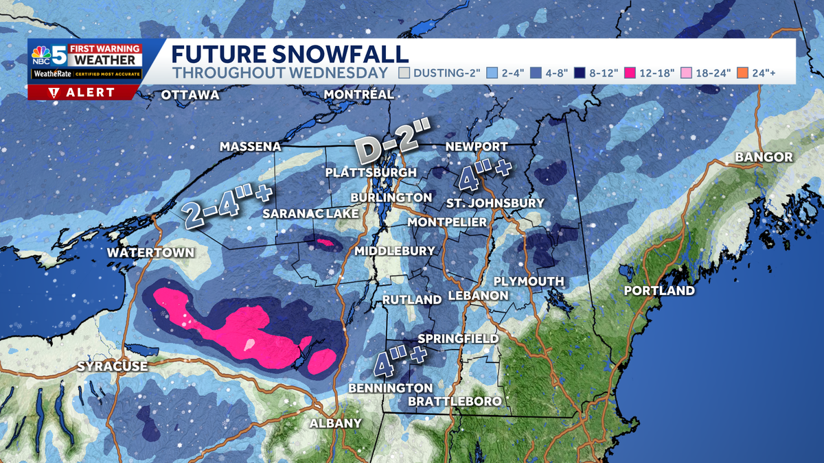
Estimated Snow Totals
As of Monday, the Champlain Valley is only expected to get between a dusting and two inches of fresh snow from Wednesday’s storm. However, a widespread two to four inches of snow is likely elsewhere in Vermont and Northern New York.
Certain areas could see more than four inches of snow, with the bullseye of this storm bringing a potential eight inches of snow to Stratton Mountain.
However, it is important to note that this storm is highly location-based, meaning some areas could see several inches of snow, while nearby towns could see very little snow.
This content is imported from Facebook.
You may be able to find the same content in another format, or you may be able to find more information, at their web site.
What is certain is that travel will be treacherous for most on Wednesday, so be sure to take extra time and be cautious when driving to and from your destination.
Looking ahead to the rest of the week, bitter cold temperatures continue into next week, with lows in the teens and single digits.
NBC5 will continue to track conditions and provide updates as we look toward Wednesday.
Snow breakdown by region
Northern Vermont/Champlain Valley/New Hampshire

Northern New York/Champlain Valley

Southern Vermont

STAY WEATHER-AWARE
For the latest weather coverage for your area, click here. Stay updated with alerts in the myNBC5 app, which you can download here.
For the best weather information and Vermont and northern New York’s Certified Most Accurate forecast, watch NBC5 News by streaming at this link.
Don’t forget to follow NBC5 News on Facebook, X (formerly Twitter), and Instagram.
Follow the NBC5 First Warning Weather team on social media: