Today’s Forecast:
HOUSTON – We’re watching and tracking a dense fog advisory until 9 a.m. Driving through fog when visibility is a quarter mile or less is like driving though a solid cloud on an open freeway. Take it slow on our roadways and make sure to use your low-beams.
Watch for reduced visibility
Plus, we’re tracking the chance for rain and thunderstorms this morning into tonight—as a front pushes through Houston, dramatically dropping our morning lows into the 30s by Monday. But today, we’re staying warm and above average.
Planning Forecast (Copyright 2025 by KPRC Click2Houston – All rights reserved.)
We’re tracking the chance for isolated thunderstorms throughout the day—slightly picking up around mid-morning and building by afternoon into date night tonight ahead of our next cold front.
Futuretrack (Copyright 2025 by KPRC Click2Houston – All rights reserved.)Tracking the rain today (Copyright 2025 by KPRC Click2Houston – All rights reserved.)Futuretrack (Copyright 2025 by KPRC Click2Houston – All rights reserved.)Sunday’s Forecast:
Once the rain passes, clouds will decrease throughout the day as a dry, cold north wind moves in. Don’t let Sunday’s forecasted high temperature fool you. Houston reaches the mid-60s early morning, but throughout the day, temperatures will continue to feel more like winter.
Cloudy start with drier, colder air filter in throughout the dayMonday the real cold arrives:
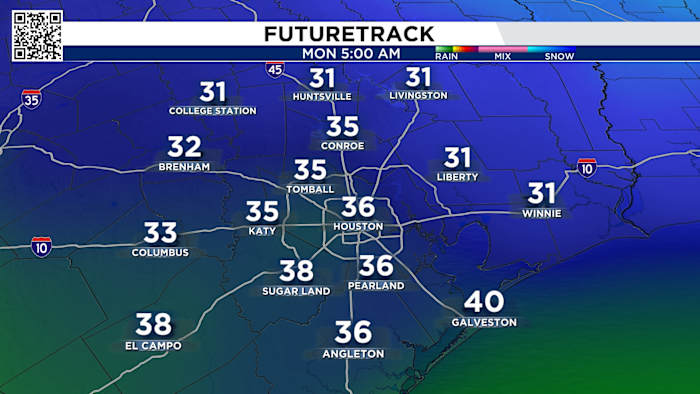
Monday morning, waking up to the 30s! A short-lived cold snap, as we’ll warm back up into the 60s and 40s by Tuesday.
Monday morning lows (Copyright 2025 by KPRC Click2Houston – All rights reserved.)Your Extended Forecast:
After the taste of cold, temperatures will warm back to the 70s by the middle of the week.
Tracking your 10 day forecast (Copyright 2025 by KPRC Click2Houston – All rights reserved.)
Stay up to date with the latest changes using Storm Tracker 2 radar and regular updates from the KPRC 2 Weather Team on Click2Houston.
Copyright 2025 by KPRC Click2Houston – All rights reserved.