
PORTLAND, Ore. (KATU) — When atmospheric rivers threaten the Pacific Northwest and west coast, a group of scientists and meteorologists take to the sky.
WEATHER | Latest Storm Tracker 2 Forecast
Hurricane Hunters, the ones who fly into the most powerful storms in earth, trade Category 5 winds for streams of water vapor moving quickly across the ocean.
The Hurricane Hunters are assisting the Scripps Institution of Oceanography at the University of California, San Diego, by flying into the storms to gather data.
Two C-130s flew into the atmospheric river that impacted Oregon and Washington in early December.
The team drops instrument packs called radiosondes into the stream of moisture. They measure temperature, pressure, water content, and winds.
In the past, the team of researchers have used Portland International Airport as a base and fly hours-long missions gathering vital information.
Thankfully, there are no atmospheric rivers in the forecast at the moment, just run of the mill winter time cold fronts.
The rain returned overnight and showers and sun breaks will be the call for your Saturday. The highs today around the region will be about 10 degrees above average.
Showers remain for Sunday and on Monday, we get a one day break from the rain. By Sunday morning, most of the western side of Oregon will have received about three-quarters of an inch of rain.
We are still watching and waiting for seasonal cold air to move into the region. Ski resorts have been begging for more snow after limited openings over the last few weeks.
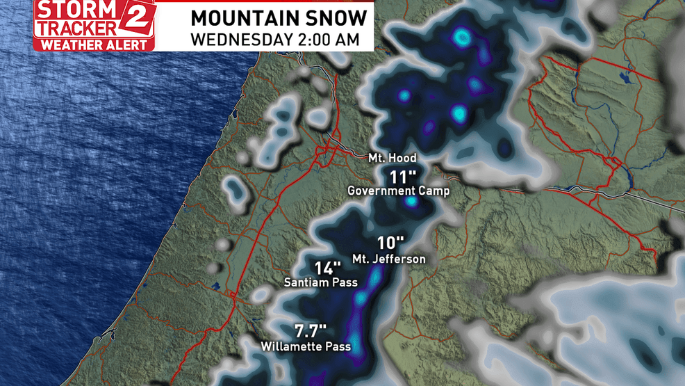
Snow is back in the forecast for the Cascades starting mid-week – Storm Tracker 2 Weather graphic
Snow will fall in the Cascades starting Tuesday as we move back toward more average temperatures.Government Camp could see just under a foot of new snow by Wednesday.
Download the Storm Tracker 2 Weather App