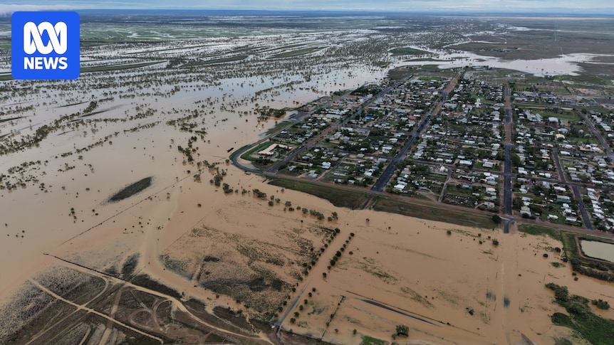
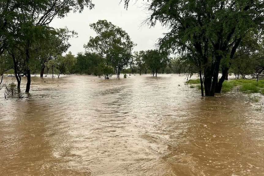
The Western River at Winton in outback Queensland has reached its major flood level, peaking at 4.05 metres overnight.
Residents and travellers in low-lying streets of Winton were voluntarily evacuated to other parts of the town on Sunday as a Watch and Act warning was issued for the area.
Winton Shire Council Mayor Cathy White said the town had an anxious few hours as the river peaked.
“It’s receding. We are expecting some more rises sometime today, but hopefully the water that’s been here already has enough time to start flowing down and won’t get any worse,” she said.
“I think we’ve seen the worst of it.”
Winton resident Vicki Jones said the water peaked about 10pm.
“It’s come up pretty high. It didn’t quite make it to the front stairs … but definitely all under the house and the work shed down the back had about 50 centimetres in it,” Ms Jones said.
“There’s a few other people in worse conditions than we are … there’s a couple of places where it’s gone through.
“We knew it was coming … the whole town’s been really helpful, so just helping anybody that needed help, as you always see in small town situations.”
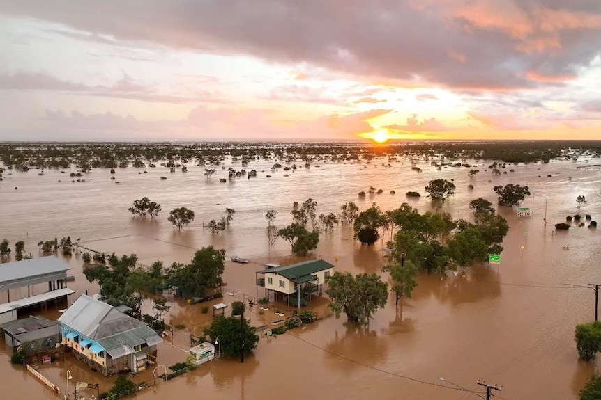
Floodwater has moved under buildings on the edge of Winton. (Supplied: David Caddis)
The Bureau of Meteorology issued an Avoid the Area warning overnight as all roads in and out of Winton are closed.
Senior forecaster Felim Hanniffy said while the peak of rainfall was anticipated to have passed for the state’s north and central west, it may be some time before water recedes.
“There’s still a lot of water across the ground that is yet to flow into river systems; those rivers will likely rise as water starts to filtrate into the system,” he said.

Floodwaters on the edge of Winton. (Supplied: Justin Smith)
“[We should see] a reprieve from the rainfall with the heavy falls contracting away from that area over the early days of this week.”
Some respite from the wet conditions is expected for communities in the north and central west, as the weather systems move towards the north tropical coastline.
The Queensland and Commonwealth governments’ jointly funded $2 million emergency fodder support package for producers in the McKinlay Shire has been expanded to those impacted in the Carpentaria, Cloncurry, Flinders and Richmond shires.
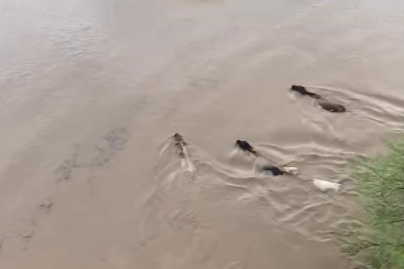
Cattle caught in floodwater on Riverdale Station near Richmond. (Supplied: Liz Tate)
Richmond preparing for stock losses
Liz Tate from Riverdale Station near Richmond thought her property was prepared for the worst of the flooding.
Rain falling on north-west Queensland had started to ease, but further heavy falls in already-swollen catchments have “devastated” some producers.
Flooded rivers still rising in outback Queensland
“We thought we were prepared … but with the river backing up and not flowing like it did in [the 2019 floods], it’s going in places that we never presumed would have ever went under,” Ms Tate said.
Flinders River, which is now at a major flood level, backs onto the property.
“The helicopters have been out moving cattle from island to island … but now there’s no islands, so they’re just swimming,” she said.
Loading…
Richmond Shire Mayor John Wharton said he was now anticipating serious cattle losses for some local producers.
“Some land owners that are out of the big wet think it’s a great season; others in flatter, black-soil country, they’re devastated,” he said.
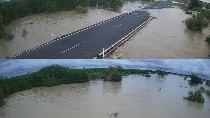
Flood cameras at Chatfield Creek in the Richmond Shire captured the road disappearing in less than 48 hours. (ABC News)
Wet weather heads toward north Queensland coast
Sustained rainfall totals around the Burdekin prompted a Watch and Act warning to be issued for Giru and surrounds on Sunday afternoon.
There was heavy rainfall overnight around Townsville, with Pallarenda recording 241mm and Picnic Bay on Magnetic Island recording 244mm since 9am Sunday.
Forecasters are turning their eye to the north tropical coast, as the risk of heavy falls contracts east, with a particular focus on the area of Bowen north through to Cairns.
“Especially during morning periods when we get those periods of local convergence, that can bring falls of 100 to 200 millimetres in a very short duration and very localised area,” Mr Hanniffy said.
“Areas across Far North Queensland, particularly coastal parts north of Ingham, still have the risk of some localised heavy falls with shower and storm activity persisting,” he said.
Coalbrook Station near Richmond has seen significant flooding. (Supplied: Danielle Moy)
The risk of a tropical low off the coast developing into a tropical cyclone later this week is still low — around a 10 per cent chance, Mr Hanniffy said.
The state’s southern end will not escape the falls, with risk of shower and storm activity stretching across parts of the south-eastern interior on Monday.
“That could generate some localised heavy falls and also some damaging winds and even potentially large hail in parts of the south east during the early parts of this week,” Mr Hanniffy said.