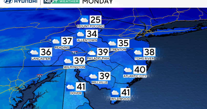
Expect more clouds than sun on Monday, with a cold start and a chilly finish in the Philadelphia region. Highs will approach the upper 30s to near 40 degrees, with light winds. A return to milder air is expected Tuesday and beyond.
NEXT big weather change
Many kids will be going back to school this week, and it will start chilly with 20s in the morning and highs below average, but warmth is on the way.
In fact, a warmer trend looks to lead us through the majority of next week with high temperatures running near or even slightly warmer than normal by Tuesday.
High temperatures on Wednesday and Thursday may be in the mid-low 50s with overnight lows actually staying above freezing.

CBS News Philadelphia
Then again, on Friday and Saturday, we’ll see a greater chance for rain and warmer temps as southerly winds usher in the mid-upper 50s! The forecast models are wavering a bit on when the rain will arrive, but the trend is more toward Friday night and Saturday.
Once the front rolls through, temps will have a steep dropoff, so right now your Sunday is looking significantly colder than Saturday, but dry.
Looking beyond, a series of cold fronts will likely bring a mix of up and down temps, but at this point we are not seeing any signs of a significant snowfall. Your NEXT Weather team will keep you posted.
Here’s your 7-day forecast:

CBS News Philadelphia
Monday: Cloudy and cold. High 39, low 26.
Tuesday: Seasonable. High 47, low 31.
Wednesday: Much milder. High 54, low 40.
Thursday: Sunny and mild. High 55, low 34.
Friday: Tracking rain. High 56, low 39.
Saturday: Tracking rain. High 59, low 51.
Sunday: Breezy and cooler. High 51, low 49.
More from CBS News