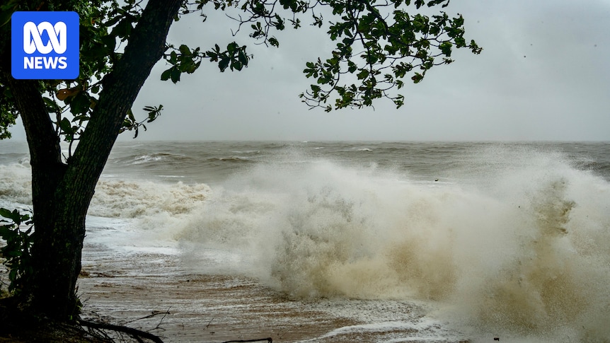
Residents in north Queensland are bracing for damaging winds, heavy rain and flooding between Cairns and Townsville, as a tropical low likely to intensify into a cyclone lingers off the coast.
The Bureau of Meteorology said tropical low 12U had a 50 to 60 per cent chance of developing into a category one cyclone — which would be named Koji — at 4pm Saturday with landfall expected just south of Townsville early on Sunday morning.
Senior forecaster Helen Kirkup said the forecast track map showed a landfall range stretching from Tully south to Bowen, with strong winds already beginning.
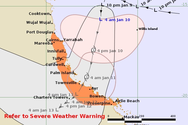
The BOM has forecast a 60 per cent chance of a cyclone developing at 4pm today. (Supplied: Bureau of Meteorology)
The system is forecast to bring damaging winds of up to 100 kilometres per hour and heavy rain to already saturated catchments, increasing the risk of flash and riverine flooding.
“We do have observations from Willis Island where they’ve been at gale force winds overnight, Flinders Reef is at 37 knots consistently, and we’re starting to see Hamilton Island’s wind gauge picking up,” she said on Saturday morning.
“[Winds] above 60 kilometres an hour can be expected. As the rain builds up, it could get a bit more intense [over Saturday night] for a lot of the coastline,” Ms Kirkup said.
A gale wind warning has been issued for the Cairns coast, Townsville coast, Mackay coast and Great Barrier Reef offshore while strong winds were anticipated for the north-east Gulf of Carpentaria, Torres Strait and Peninsula coast.
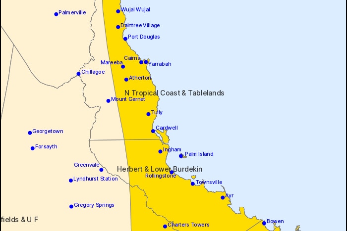
Severe weather and flooding is forecast for the Queensland coast today. (Supplied: The Bureau of Meteorology)
Tides are likely to be higher than normal between Port Douglas and Airlie Beach over the weekend, but should not exceed the highest tide of the year.
Forecaster Morgan Pumpa said the system had the potential to dump significant amounts of rain before it made landfall.
“We are looking at 150 to 200 millimetres with some isolated falls of around 350mm possible as well,” she said.
“Our warning zone is currently from Port Douglas to Tully, including Cairns and Innisfail and our watch zone is from Tully to Airlie Beach, including Townsville and Bowen as well.

In an emergency phone Triple Zero
“We are looking at a significant event on Saturday and through to Sunday.”
Major flooding is possible at Giru from late Saturday, with heavy to locally intense rainfall forecast across the Haughton River catchment throughout the day.
The Herbert River catchment is also expected to see heavy rainfall across the catchment, which could cause major flooding along the lower Herbert catchment from early Sunday.
Palm Island braces for impact
Sitting just to the side of the storm’s expected path, 65km north of Townsville, is the small community of Palm Island.
Its roughly 4,000 residents were cut off from the mainland on Friday when flights and ferries were cancelled.
Several high-risk residents were evacuated from the island by Townsville Hospital and Health Service on Thursday and Friday.
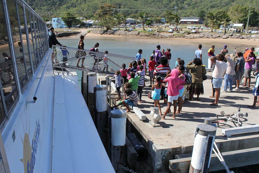
The Ferry service between Palm Island and the mainland has been cancelled through to at least Sunday. (Michael Bromage – ABC Open)
Palm Island Aboriginal Shire Council Mayor Alf Lacey said people who lived in family camps had been encouraged to stay in homes in the township until the weather settled.
“We’re a resilient bunch of people here, and we’ve been through quite a number of these events before,” he said.
“When the community needs to step up, it steps up.”

Valmae Doomadgee says residents on Palm Island have been cut off from the mainland by the cancellation of ferries and flights. (Supplied: Valmae Doomadgee)
Palm Island resident Valmae Doomadgee said the wind started picking up on the island on Friday, however, residents were not too concerned.
“[The kids] are definitely aware there is a cyclone coming,” she said.
“No-one is worried about the weather at the moment; they are worried about fishing — the fishing has been good.”
Here we go again
Back on the mainland, communities from Hope Vale to Ayr have been preparing for strong winds and heavy-to-intense rainfall.
Tully social worker Reegan Davis said the town was well rehearsed in disasters, but some who went through flooding nearly a year ago were anxious about what may be in store.
“They are very much still in the recovery phase, and some of them are still not back in their homes yet,” she said.

Reegan Davis says some Tully residents are still recovering from last year’s summer flooding. (ABC Far North: Holly Richardson)
Ms Davis said many people, particularly in rural areas, had been living in caravans or insecure dwellings.
She said services like Centacare had also been helping and encouraging homeless locals to find places to stay with family and friends or through support services.
Ms Davis said people experiencing homelessness should head to a support centre.
“Get some plastic bags to put those items in, like medications, clothes,” she said.
Forty kilometres south at Cardwell, longtime resident Dianne Bach spent the week preparing after her property flooded for the first time less than 12 months ago.
“We never dreamt it would come indoors like it did… [we’ve been home] probably about five weeks now, still a long way from being sorted but we’re getting there,” she said.
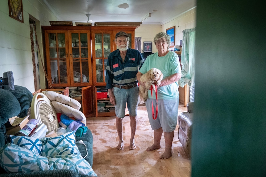
John and Dianne Bach, pictured in Febuary 2025, after their home was inundated with floodwater for the first time. (ABC Far North: Brendan Mounter)
With too many doors and openings around her property, sandbags were not an option for Mrs Bach. She said her husband, John, had been working hard to build flood gates instead.
“They won’t be done in time… it’s nervy as of right now. We’ve been putting things up in case it floods, tying stuff down all day,” she said.
Farmers in the firing line
North Queensland’s agricultural community is still recovering from last summer.
Ingham region sugarcane farmer Robert Lyon said he was concerned strong winds would snap his cane, and that flooding would wash away repairs made after last summer’s flood.
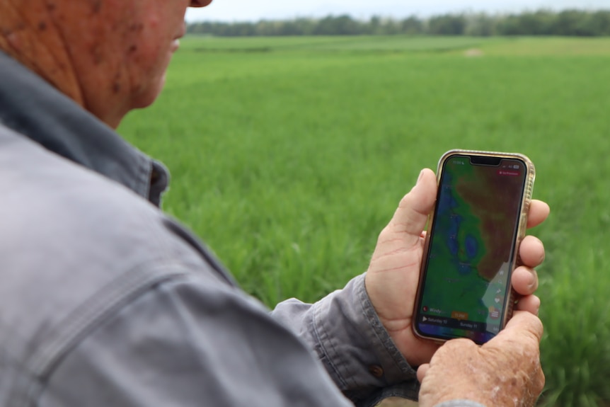
Cane farmer Robert Lyon was keeping a close eye on the system as it neared the North Queensland coast. (ABC Far North: Sophie Johnson )
“It’s been 11 months since that major flooding disaster happened,” he said.
“Everyone’s still in a point of recovery … they’ll be in recovery for quite some time to get things repaired.
“Back-to-back repairs, back-to-back finding the bank in the back pocket.”
Mr Lyon said the weather would also take a significant toll on some locals’ mental health.
“There will be some very concerned people, businesses, growers and residents,” he said.
“A lot of growers won’t show their mental issues; they’ll bottle it up, and it hurts.”
Water restrictions amid heavy rainfall
Cairns residents have been urged to restrict water usage to drinking, cooking and washing only, with level 4 water restrictions now in place.
Deputy Mayor Brett Olds said this was a precautionary measure.
He said in the 72 reservoirs in Cairns, there was usually only enough water for a few days’ supply, and sediment stirred up by heavy rainfall could force treatment centres to shut down.

Brett Olds says level four water restrictions are in place as a “precautionary measure”. (ABC News: Curtis Rodda)
“You can’t put mud through our filters,” he said.
Mr Olds said while the treatment centres were currently online, more rain could mean they might be turned off.
“We want to extend as long as we can, the time we have for potable water,” he said.