FORECAST HIGHLIGHTS
-
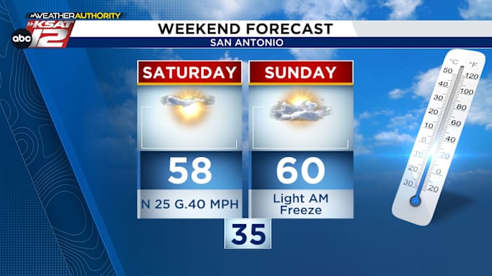
GUSTY SATURDAY: Gusty winds and chilly wind chills this morning
-
FIRE DANGER Elevated to near-critical fire weather conditions today
-
SUNDAY FREEZE? Temperatures drop into the 30s; Hill Country likely to see freezing temps
FORECAST
You may want to grab that extra layer this morning! A cold front moved in overnight bringing gusty winds & wind chills.
FIRE DANGER TODAY
Dry air and breezy to windy conditions will create elevated fire danger across South Central Texas. Most areas will see moderate risk, but a few spots could reach high. Winds will gradually ease this evening, but dry air sticks around.
Gusts to 40 mph possible Saturday morning (Copyright KSAT-12 2026 – All Rights Reserved)
POSSIBLE FREEZE
Expect a temperature drop this weekend with highs in the 50s and 60s and wind chills in the 20s and 30s. By early Sunday, San Antonio will dip into the mid-30s, and areas outside Loop 1604 could briefly freeze.
A light freeze is possible Sunday morning (Copyright KSAT-12 2026 – All Rights Reserved)
The Hill Country and areas west and north of the city face the greatest freeze risk, with lows below 32°. Residents in those areas should take precautions—cover plants, protect pipes, and bring pets inside—as the coldest air arrives late Saturday night into Sunday morning.
NEXT WEEK
After a chilly weekend, highs rebound into the 60s next week. A weak front moves through Wednesday, but overall, expect mild, sunny, and calm weather with no major storm threats.
7 Day Forecast (Copyright KSAT-12 2025 – All Rights Reserved)Daily Forecast
KSAT meteorologists keep you on top of the ever-changing South Texas weather.
QUICK WEATHER LINKS
Copyright 2026 by KSAT – All rights reserved.