Widespread and heavy rainfall expected for Jacksonville
JACKSONVILLE, Fla. – More rain is on the way for northeast Florida and southeast Georgia, Meteorologist Katie Garner is warning that nearly everyone in the viewing area is likely to see wet weather today. “We have the potential to see rain across our entire viewing area,” The Weather Authority shared, noting that while rainfall will be especially heavy further north, no part of the area is being left out.
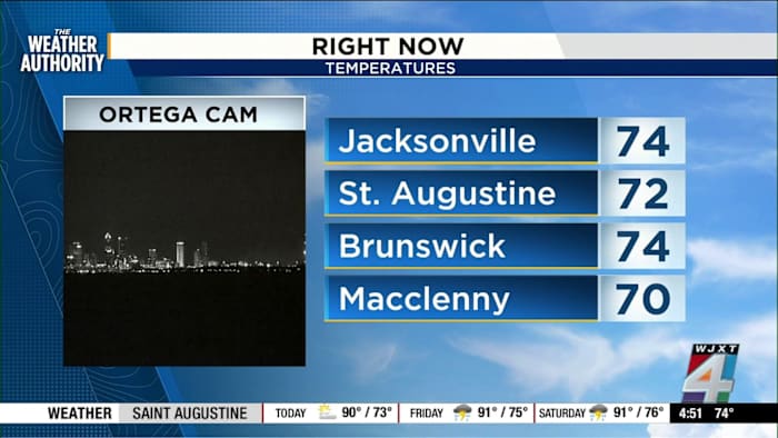
The current pattern—clear, sunny mornings followed by storms—looks set to continue. High rain chances are in the forecast each afternoon, with some downpours expected to be locally heavy. Temperatures at sunrise were already mild: 74 degrees in Jacksonville, 72 in St. Augustine, 74 in Brunswick, and 70 in Macclenny. By afternoon, storms are likely to pop up across communities including Jacksonville proper (San Marco), Palatka, Keystone Heights, Macclenny, Middleburg, and Brunswick.
Storm risk ramps up in Georgia, but Jacksonville could see impacts
Today’s main severe threat is forecast north of Jacksonville, according to The Weather Authority’s Exact Track 4D outlook. A general risk for storms stretches from noon to 10 p.m., with the window for strong to severe storms set between 4 and 9 p.m.—primarily impacting southern Georgia, from Brunswick northward. Still, Jacksonville and areas extending south to Flagler Beach should be prepared for occasional wind gusts, frequent lightning, and brief periods of very heavy rain.
The Weather Authority emphasized these pop-up storms will be scattered and difficult to pinpoint. Even outside the highest risk zone, quick heavy downpours are possible nearly anywhere. The futurecast shows the most active weather moving in from 2 to 3 p.m., then continuing through the evening, especially north and inland.
High temperatures and heat index concerns across the region
Don’t expect the heat to let up, either. While mornings start off in the 70s, highs are expected to reach the low- to mid-90s across the region, with Jacksonville looking at a high near 94 degrees. That heat, combined with high humidity, means it will feel even hotter. The Weather Authority noted that these conditions will fuel development of showers and storms—so keep an umbrella and water bottle handy, especially for any outdoor plans after lunch.
The extended outlook offers more of the same: highs in the 90s, lows in the mid-70s, and a daily chance of rain through the next week. If you catch wild weather near you, remember you can share photos or video with News4JAX via SnapJAX.
Copyright 2025 by WJXT News4JAX – All rights reserved.