The heat wave has arrived.
Temperatures and humidity are climbing as the tri-state heads into a likely record-shattering heat wave, where it could feel like 100 degrees or hotter through Wednesday.
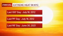
Tuesday looks like the hottest air temperature we’ll have seen in Central Park since 2012.
“The National Weather Service has upgraded the Heat Watch to an Extreme Heat Warning for New York City, beginning tomorrow. This is the highest level of heat alert,” the NWS posted over the weekend.
Check latest weather alerts here.
Gov. Kathy Hochul on Sunday declared a state of emergency for 32 of the state’s 62 counties — including all five boroughs of New York City. The state’s fire prevention teams and swift water rescue crews have been put on standby for any possible emergencies.
“I urge all New Yorkers to stay weather aware and take precautions to stay vigilant and safe as extreme heat and severe weather are expected to continue impacting the State over the next couple of days,” Hochul said in a statement.
Heat stroke symptoms set on fast
This type of heat is dangerous, especially because it is coming on so quickly, before our bodies have any chance to acclimate to it. Because of this, be extra careful outside this week. Limit your time outside, limit strenuous physical activity, stay in the shade as much as possible, and drink plenty of water.
Vulnerable groups will be at risk, especially due to the prolonged exposure, likely through the end of the week.
On top of that, all three of the hottest days — Monday, Tuesday and Wednesday — will approach records, and not just at Central Park. Record-warm lows are possible those days, too, based on our current forecast.
This heat dome will keep showers and storms away until Thursday. That helps break the heat a bit by the end of next week.