The wait for significant drought relief is finally over.
After two years of high-pressure domination, a triplet of low-pressure systems is about to deliver rain across nearly every agricultural region of Australia, and for once, the best falls will reach all the right places.
Rainfall this week is likely to be the heaviest in one to two years for much of South Australia and the southern Murray Basin, while many Western Australian farmers are rejoicing through the wettest July in four years.
Across alpine regions, the winter storms will dump further heavy snow — laying the platform for the 2025 ski season to rival some of the best so far this century.

Most of Australia will see rain during the next 10 days, with at least 20mm across most agricultural regions. (ABC News)
The perfect recipe for rain
The ingredients for widespread rain are lining up on the weather maps this week.
Three rain-producing fronts will sweep across southern states, but unlike standard fronts, each will lead to the formation of a low-pressure system near our southern coastline — the exact pattern that has been notably absent during recent years.
To complete the recipe for a solid soaking, an infeed of tropical moisture will flow into system two, which, along with its relatively slow movement, will ensure more than just passing showers.
Front number one already hit WA on Sunday, dropping up to 35 millimetres on the coast and up to 22mm over the wheat belt.

Nearly every agricultural region of Australia is likely to get rain. (Supplied: Jacob Vlatko )
The system then swept into SA on Monday while spawning a low-pressure system in the Bight, and continues to track east on Tuesday, spreading showers over south-east Australia.
During the next 48 hours, the SA coast, along with the ranges of New South Wales and Victoria, can expect around 10 to 20mm of rain; however, this system is just a taste of the main event.
Another powerful front will reach south-west WA late on Wednesday, and this system will cause the development of a band of cloud across Australia’s interior on Thursday as it draws moisture south from the northern Indian Ocean.
This rainband will then intensify on Friday and wrap around a developing low near Eyre Peninsula, leading to the most widespread day of rain SA has seen in several years.
Loading…
The band of rain will then spread across eastern states from late Friday to Sunday, stretching thousands of kilometres from tropical Queensland to Tasmania.
Sunday will also see a third vigorous front arriving on the shores of WA, leading to another burst of widespread showers for the southern half of the state.
A months’ worth of rain from Bunbury to Bundaberg
Below is a forecast map of rain across the next eight days from a leading global model, and it shows at least 20mm across nearly all agricultural areas of southern Australia, and up to around 100mm around the Alps, along with small pockets of the WA and SA coasts.
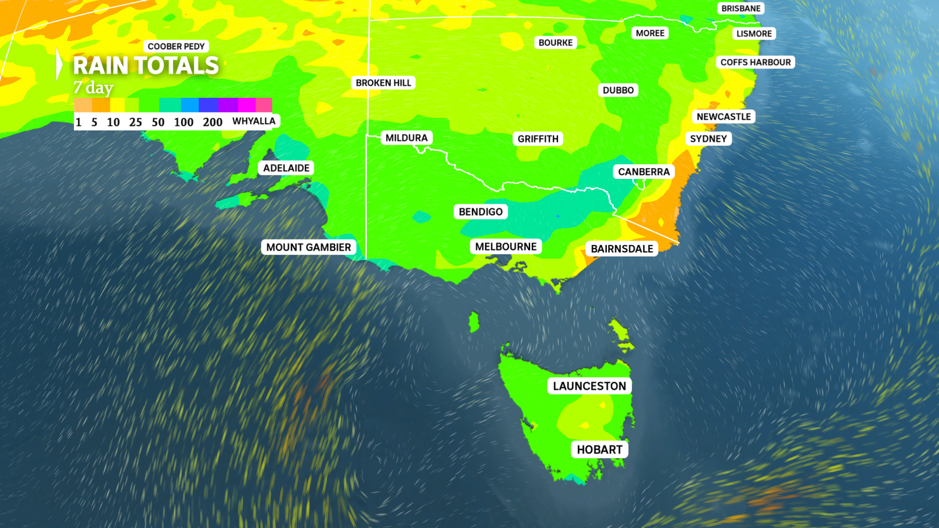
During the next week the best soaking in up to two years is likely over parts of Victoria and SA. (ABC News)
For many regions in drought, the upcoming week should produce the heaviest falls in well over a year, including:
- Adelaide, 50 to 80mm, heaviest since December 2023.
- Clare, 30 to 50mm, heaviest since December 2023.
- Renmark, 20 to 30mm, heaviest since November 2024.
- Mildura, 20 to 30mm, heaviest since November 2024.
- Horsham, 30 to 40mm, heaviest since November 2023.
- Bendigo, 40 to 60mm, heaviest since January 2024.
- Griffith, 20 to 30mm, heaviest since November 2024.
Widespread rain will also spread to areas of eastern Australia further north that are not in drought, with up to 20mm landing as far north as tropical Queensland.
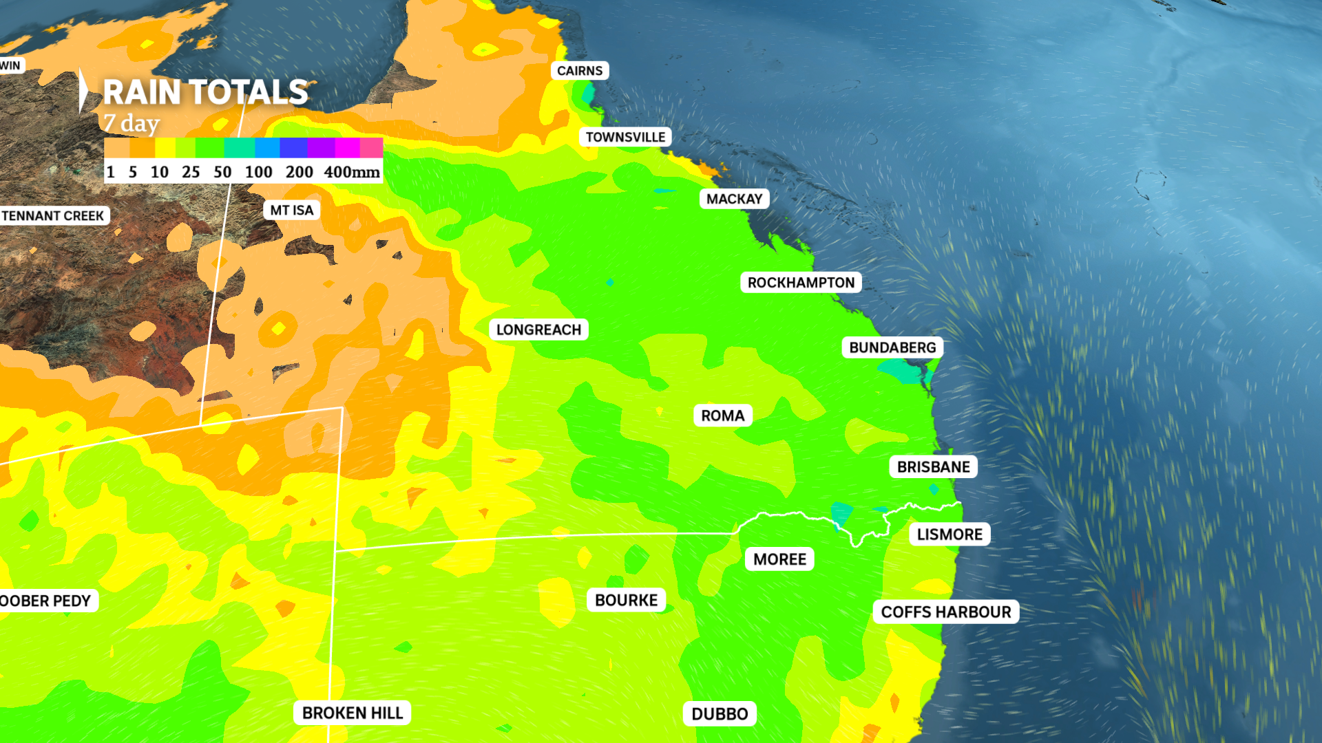
An unseasonably wet week is ahead for Queensland and northern NSW, where heavier rain typically falls during the warmer months of the year. (ABC News)
Of course, one swallow does not make a season, and what is critical for sustained drought relief is follow-up falls.
After drenching WA on Sunday and Monday, the third front will likely reach south-east states by the middle of next week, while medium-range outlooks are favouring further fronts through the beginning of August.
This all points to an easing of the current drought, at least in the short term, although it will take several months of good rain and restocking before farmers consider the drought may be breaking.
A win for snow season
Forecasts for this winter hinted at drought relief, and that is an outcome that is paying off. However, what is more unexpected is the snow season.
Heavy snow in June and July has lifted the natural snow depth at Spencers Creek, between Perisher Valley and Charlotte Pass, to around 1.5 metres — about 40 centimetres above average for this point in the season.
After a wintry mix of rain and wet snow on Tuesday, the upcoming series of fronts should deliver at least 50cm of fresh snow this week.
For Spencers Creek, which is a representation of the snow quality on the higher slopes, this week’s storm should comfortably send the season’s peak depth to near 2 metres — a mark that has only been reached eight times this century.
Considering snow normally continues to accumulate through August, and occasionally through September, a platform has been laid for potentially the best ski season since at least 2000.