![]()
Hurricane season 2025: What to know, how to prepare
What does each hurricane category mean? A guide to the 2025 hurricane season in Florida.
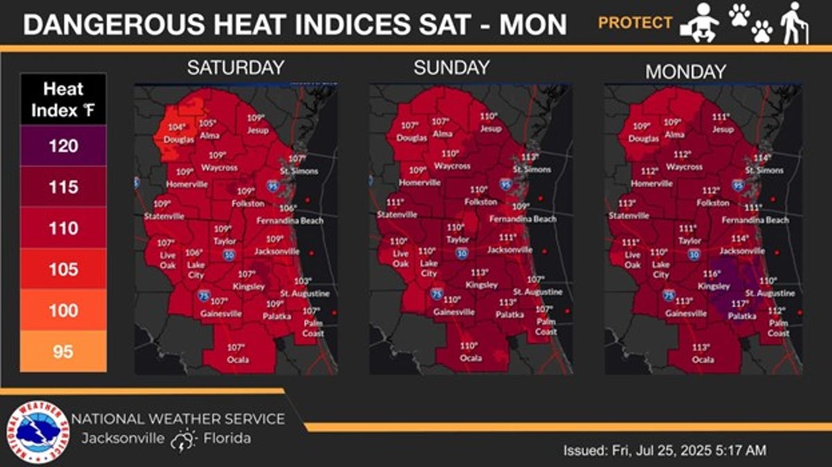
- Jacksonville will experience sunny days with high temperatures near 100 degrees and heat index values up to 114.
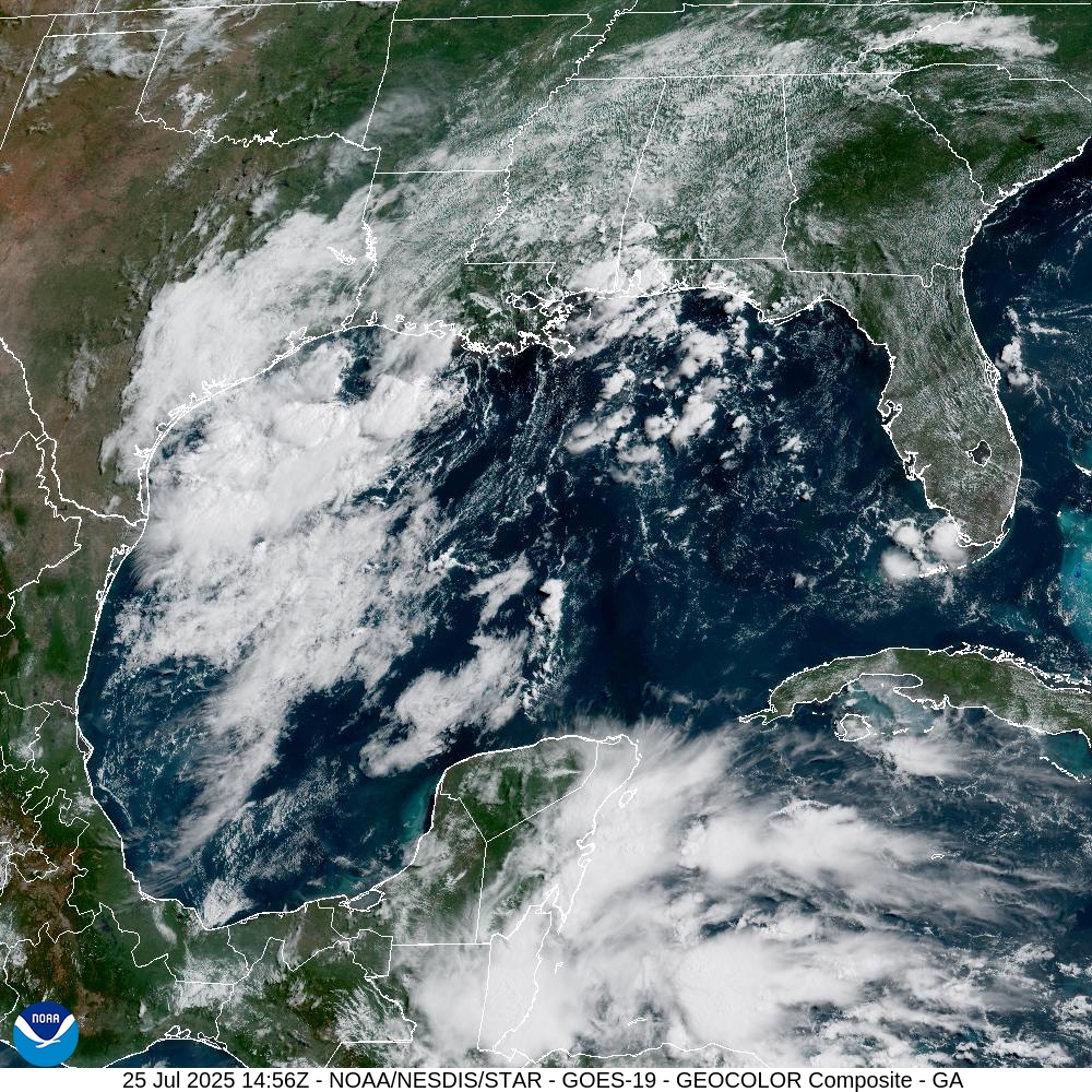
- A low-pressure system is moving from the Gulf Coast towards Texas and Louisiana, reducing the chance of further development.
- The National Hurricane Center is monitoring four tropical waves in the Atlantic.
The low-pressure system bringing rain and thunderstorms across Florida the last few days is expected to move out of the Gulf inland over southeastern Texas or western Louisiana going into the weekend, ending any chances for further development, according to the National Hurricane Center’s July 25 update.
“Today will be the last day of widespread heavy rainfall across the Gulf Coast,” said National Weather Service meteorologist Mussie Kebede. “Troughing along the coast has offered a lifting mechanism for storm development/organization over the last few days, but should wind down as an upper ridge in the vicinity strengthens.
However, this won’t be the case for Jacksonville. According to the National Weather Service, the possibility of thunderstorms is expected to diminish this afternoon and evening for Jacksonville, meaning bright sunny days. Unfortunately, the clearance of showers will allow heat and humidity to build to dangerous levels.
Inland high temperatures are expected to soar to near 100 degrees, with heat index values climbing each day, reaching the 108- to 114-degree range by Sunday and Monday. Heat advisories will likely be issued for Saturday across most of the Jacksonville area, and Extreme Heat Watches may be necessary by Sunday and Monday.
What’s the weather in Jacksonville today: July 25, 2025
Today, Jacksonville is kicking of the weekend hot and steamy with a decreased chance of thunderstorms. During the day, sunny and hot conditions are expected with a maximum heat indices of 101 to 108 this afternoon. The National Weather Service is calling for a 20 percent chance of showers and thunderstorms after 1pm. However, it is warning that the Highest heat indices for today will be from noon to 6 p.m.
Tonight the sky is expected to be mostly clear, with a low around 76. Southeast wind around 6 mph becoming calm in the evening.
What is the weather in Jacksonville this weekend?
This weekend will be sunny, hot, and humid. Dangerous heat will continue through the weekend and into early next week. High temperatures will approach 100 degrees, with heat index values ranging from 108 to 114. Heat Advisories are likely across the entire area. Only isolated afternoon and evening thunderstorms are expected inland over the weekend.
Saturday, expect mostly sunny skies with a 20 percent chance of showers and thunderstorms developing after 2 p.m. Highs will reach around 97, with heat index values as high as 106. Winds will be calm in the morning, shifting to the northwest around 5 mph by afternoon. Saturday night will be mostly clear and warm, with a low near 77 and light winds.
Sunday will be even hotter, with a high near 99 under sunny skies. Light northwest winds will shift to the northeast by afternoon. Sunday night will remain mostly clear and mild, with a low around 79.
Florida weather radar for July 25, 2025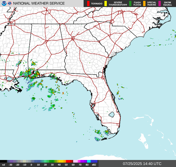 What to know about tropical wave development
Elsewhere, the NHC is now tracking four tropical waves moving westward across the Atlantic: one near the Lesser Antilles, one in the open Atlantic, a third off the coast of Africa, and a new one in the Caribbean.
It’s still hot out there. Heat index values (‘real feel” temperatures) are expected to reach 100-107 in different areas around the state, but there are no heat advisories in effect today. However, the unusual heat and humidity the country has suffered through the last week will continue through early next week, Labede said, while building across the Southeast and Mid-South this weekend.
➤ Weather alerts via text: Sign up to get updates about current storms and weather events by location
The next named storm of the 2025 Atlantic hurricane season will be Dexter.
Historically, the fourth named storm of the Atlantic hurricane season arrives Aug. 15. The last two named storms of the season — Barry and Chantal — developed earlier than normal.
Here’s the latest tropical advisory from the National Hurricane Center as of 8 a.m. July 25:
Where is the low-pressure area?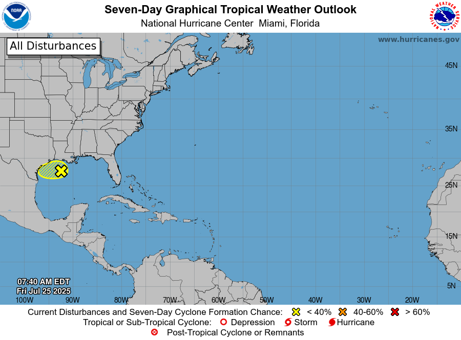
A broad area of low pressure located about 100 miles south of the coast of southwestern Louisiana continues to produce disorganized showers and thunderstorms. This system is moving west-northwestward toward the Texas coast, and it has limited time to develop before it moves inland tonight.
Regardless of formation, locally heavy rainfall is likely over portions of the northwestern Gulf coast during the next couple of days.
- Formation chance through 48 hours: Low, 10%
- Formation chance through 7 days: Low, 10%
What else is happening in the tropics?
The National Hurricane Center is tracking four tropical waves.
- Tropical wave 1: A tropical wave is analyzed over the eastern Atlantic near 20W, from 17N southward moving westward at 10 to 15 kt. Isolated moderate convection is depicted just west of the wave axis.
- Tropical wave 2: A central Atlantic tropical wave is near 40W, from 18N southward, moving west at 10 to 15 kt. No significant convection is active with this wave.
- Tropical wave 3: A central Atlantic tropical wave is near 56W, from 18N southward, moving at 20 to 25 kt. Scattered showers and thunderstorms are active from 10N to 14N between 54W and 57W.
- Tropical wave 4: A Caribbean tropical wave is analyzed near 76W, from 19N southward moving west at 25 kt. Scattered moderate convection is noted from 15N to 19N between 75W and 78W.
Weather watches and warnings issued in FloridaNational Weather Service Florida forecast for July 25
- Pensacola, western Panhandle: Showers and thunderstorms, mainly before 4 p.m. High near 87. South wind 10 to 15 mph. Chance of precipitation is 80%. New rainfall amounts between a half and three quarters of an inch possible.
- Tallahassee, central Panhandle: Showers and thunderstorms likely, mainly before 4 p.m, then showers likely and possibly a thunderstorm after 4 p.m. Mostly sunny, with a high near 89. South wind 5 to 10 mph. Chance of precipitation is 60%. New rainfall amounts of less than a tenth of an inch, except higher amounts possible in thunderstorms.
- Jacksonville, North/Northeast Florida: A 20% chance of showers and thunderstorms after 1 p.m. Sunny, with a high near 93. Heat index values as high as 103. Southeast wind 7 to 13 mph, with gusts as high as 20 mph.
- Daytona Beach to Stuart, East/Central Florida: A 20% chance of showers and thunderstorms after 1pm. Sunny, with a high near 90. Heat index values as high as 102. Light south-southeast wind becoming east southeast 5 to 10 mph in the morning.
- West Palm Beach/South Florida: A 20% chance of showers and thunderstorms before noon. Sunny, with a high near 86. Heat index values as high as 100. Southeast wind around 15 mph, with gusts as high as 20 mph.
- Naples/ Southwest Florida: A 20% chance of showers and thunderstorms after 11am. Sunny, with a high near 94. Heat index values as high as 107. East wind 6 to 10 mph becoming south in the afternoon.
- Fort Myers to Sarasota, West/Southwest Florida: Scattered showers and thunderstorms, mainly after 2 p.m. Mostly sunny, with a high near 90. Heat index values as high as 101. East southeast wind around 10 mph becoming south southwest in the afternoon. Chance of precipitation is 50%. New rainfall amounts between a tenth and quarter of an inch, except higher amounts possible in thunderstorms.
➤ How to set up emergency cellphone notifications for flash flood warnings and safety tips
2025 hurricane season so far
An average Atlantic hurricane season has 14 named storms, seven hurricanes, and three major hurricanes.
Here’s when this year’s named storms have developed, compared to historical averages:
- Tropical Storm Andrea: formed June 24. Average start date: June 20
- Tropical Storm Barry: formed June 29. Average start date: July 17
- Tropical Storm Chantal: formed July 5. Average start date: Aug. 3.
- Next up, Dexter: Average state date: Aug. 15, with the average first hurricane forming Aug. 11.
Hurricane names for 2025 season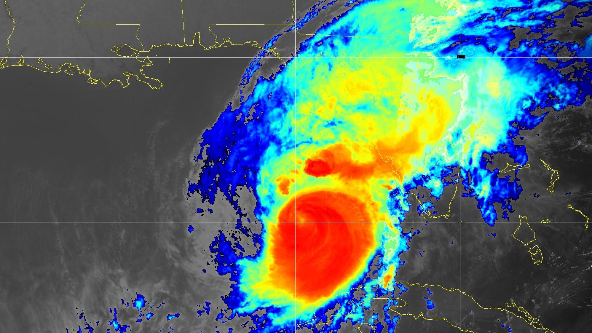
![]()
What are the names for the 2025 Atlantic hurricane season.
See names for 2025 Atlantic hurricane season, from Andrea to Wendy. Is your name on the list?
Here are the names for the 2025 Atlantic hurricane season, along with how to pronounce them:
- Andrea (June 24)
- Barry (June 29)
- Chantal (July 5)
- Dexter: DEHK-ster
- Erin: AIR-rin
- Fernand: fair-NAHN
- Gabrielle: ga-bree-ELL
- Humberto: oom-BAIR-toh
- Imelda: ee-MEHL-dah
- Jerry: JEHR-ee
- Karen: KAIR-ren
- Lorenzo: loh-REN-zoh
- Melissa: meh-LIH-suh
- Nestor: NES-tor
- Olga: OAL-guh
- Pablo: PAHB-lo
- Rebekah: reh-BEH-kuh
- Sebastien: se-BAS-tee-en
- Tanya: TAHN-yuh
- Van: van
- Wendy: WEN-dee
When is the Atlantic hurricane season?
The Atlantic hurricane season runs from June 1 through Nov. 30.
Ninety-seven percent of tropical cyclone activity occurs during this time period, NOAA said.
The Atlantic basin includes the northern Atlantic Ocean, Caribbean Sea and Gulf of America, as the Gulf of Mexico is now known in the U.S. per an order from President Trump. NOAA and the National Hurricane Center are now using Gulf of America on its maps and in its advisories.
When is the peak of hurricane season?National Hurricane Center map: See what forecasters watching now
Systems currently being monitored by the National Hurricane Center include:
Why does NHC say ‘tropical cyclone’ on its maps instead of hurricane or tropical storm?
Tropical cyclone is the generic term used by the National Weather Service, NOAA and the National Hurricane Center for any tropical system, even if it’s in the tropical Atlantic basin.
To be more precise, a tropical cyclone is a “rotating, organized system of clouds and thunderstorms that originates over tropical or subtropical waters and has closed, low-level circulation,” NOAA said.
Once maximum sustained winds reach 74 mph, what it is called is determined by where it originated:
- Hurricane: for storms in the North Atlantic, central North Pacific, and eastern North Pacific.
- Typhoon: for storms in the Northwest Pacific.
- Cyclone: for storms in the South Pacific and Indian Ocean.
Interactive map: Hurricanes, tropical storms that have passed near your cityStay informed. Get weather alerts via textWhat’s next?
We will update our tropical weather coverage daily.
Download your local site’s app to ensure you’re always connected to the news. And look for our special subscription offers here.