
Extreme heat returned to the tri-state area with a vengeance Friday, pumping feels-like temperatures near 110 degrees in parts of New Jersey before humidity-fueled evening storms brought down trees.
A cold front ushered in showers and storms, with the storms hitting the NYC metro area on the latter end of that timeline. Parts of New York City along with neighboring New Jersey and Long Island counties were under severe thunderstorm warnings in the early evening.
Newark and Staten Island got hit with the strongest wind gusts, which may have reached up to 65 mph as storms passed through between 3:30 and 4 p.m. There were multiple reports of trees down on Staten Island and video from Citizen App showed a large tree down blocking a street in Flushing, Queens.
In New Jersey, trees and branches were reported down in Newark, while a tree came down onto a house in Springfield. NJ Transit service along the Morris and Essex Line was temporarily suspended in both directions between Madison and Dover due to a tree that had fallen onto overhead wires. Northeast Corridor and North Jersey Coast Line service was also subject to half-hour delays.
A woman in the Westchester County town of Bedford was hit and injured by a tree that fell. In the same town, there was a report of a tree that had come down onto a car with people trapped inside.
Multiple counties in Central and North Jersey were under under severe thunderstorm warnings as the evening has continued. A severe thunderstorm watch is in effect throughout the evening as well.
All three NYC-area airports were under temporary ground stops due to the storms, with delays of at least an hour and a half. Each of JFK Airport, LaGuardia Airport and Newark Airport had more than 300 delays reported; LaGuardia had nearly 90 flights canceled.
There were more than 19,000 without power on Staten Island as a result of the storms, but no other widespread outages were reported in New York or New Jersey.
Weekend forecast
After the storms, we get a bit of a reprieve.
It won’t be just rain chances diminishing; our humidity will lower, too. Dew points will dip slightly as we head into Saturday. It’ll still be a hot and sticky day, but comparatively, we will not be seeing the same dangerous heat of the day prior.
On top of the modest temperature and humidity improvements, skies will be mostly sunny; it’ll be a pretty nice day to get outside and even take a trip to the beach.


Don’t get used to the improving forecast because already by Sunday, we’re back in the tropical humidity. Scattered storms return, too. It won’t be a washout, but the shower and storm threat will increase as we head into the afternoon and evening. And unlike Friday’s storms, these will not do anything to provide relief from the heat and humidity, even temporarily.
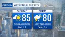
Instead, we’ll keep the tropical humidity with temperatures near 90 degrees straight into the start of next week; we could even get yet another day with heat advisories by Tuesday.
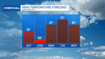

But there is some hope on the horizon. An approaching midweek cold front will help knock our temperatures down a good 5 to 10 degrees and even wipe away some of the humidity. But if that is not enough for you and you’re tired of the heat altogether, don’t worry: the start of autumn is less than 2 months away.